
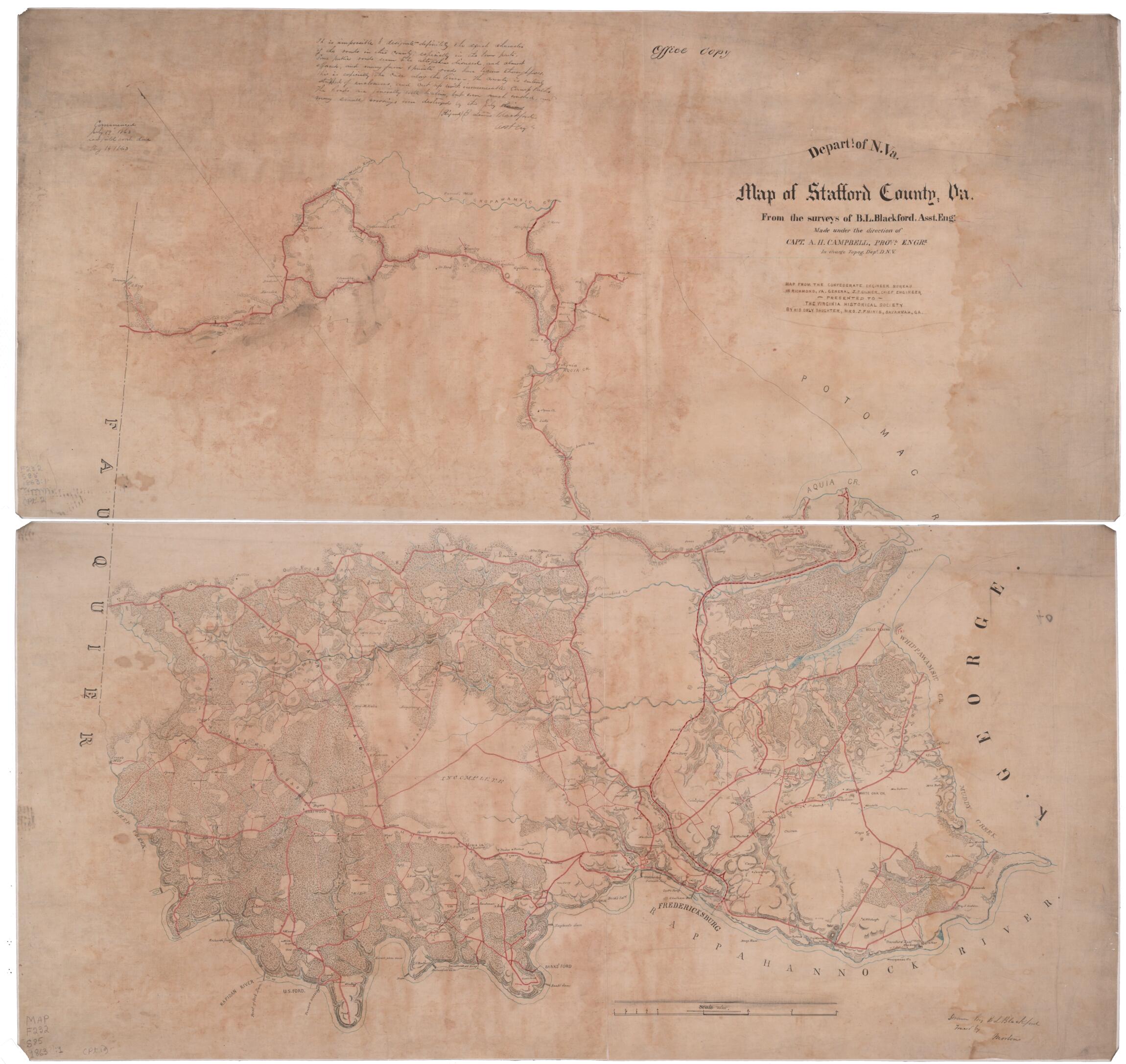
Map of Stafford County, Va 1863
- Regular price
-
$108.95 - Regular price
-
$103.95 - Sale price
-
$108.95
Buy one map, get any other map in our collection for 50% OFF! Add to cart to see discount.
Couldn't load pickup availability
About This Map
Discover the timeless beauty of our fine art quality printed reproduction of this antique map. Perfect for history enthusiasts, collectors, and interior decorators.
Restored with meticulous attention to detail by our team with over a decade of experience, this stunning reproduction captures the intricate artistry and historical significance of the original map.
Whether you're a collector or seeking a unique decor piece, this archival-quality map reproduction is a timeless addition to any space. Order now to bring history to life!
Old map of Stafford County, United States, Virginia.Created by B. L. (Benjamin Lewis) Blackford, Albert H. (Albert Henry) Campbell, Confederate States of America. Army. Dept. Of Northern Virginia. Chief Engineer's Office in 1863.
- "Commenced July 19[,] 1863[.] Last field work done Aug. 14[,] 1863."--handwritten note on map.
- "It is impossible to designate definitely the exact character of the roads in this county, especially in the lower part. Some public roads seem to be altogether disused, and almost [effaced], and many farm & private roads have become thoroughfares. This is especially the case along the River -- The county is entirely stripped of enclosures, and cut up with innumerable camp paths. The Roads are generally well [beaten?], but [even?] much washed, and many small crossings were destroyed by the July rains. [Signed] B. Lewis Blackford, Asst. Engr."--handwritten note on map.
- "Map from the Confederate Engineer Bureau in Richmond, Va. General J.F. Gilmer, Chief Engineer[.] Presented to the Virginia Historical Society by his only daughter, Mrs. J.F. Minis, Sav[ana]h, Ga."--handwritten note on map.
- "Office copy."--notation on map.
- Forms part of the Gilmer Map Collection.
- Relief shown by hachures.
- Shows towns, waterways, roads, geographic features and land owners.
- Gift of Mrs. Louisa Porter (Gilmer) Minis (i.e., Mrs. J. F. Minis), Savannah, Ga., in 1911.
- Manuscripts o.s.
- For the best legibility, order your map in the original size or larger. Most maps have intricate detail and small text that is best appreciated when the print size hasn't been reduced.
- Sizes labeled "Fits a Standard Frame" will drop right into any frame that you purchase in that size. The sizes that we offer are commonly available online and at most retail stores.
- Our standard sizes are recommendations based on the aspect ratio of the original map, but still may require some added "white space" in one dimension to fit.
- Non-standard sizes will require custom framing, and we suggest taking your print to the frame shop of your choice after you receive it for the best results.
- Custom sizes are available, simply contact us for a quote.
Below is an approximation of the scale of a few standard sizes, and how they might appear in your space.

