
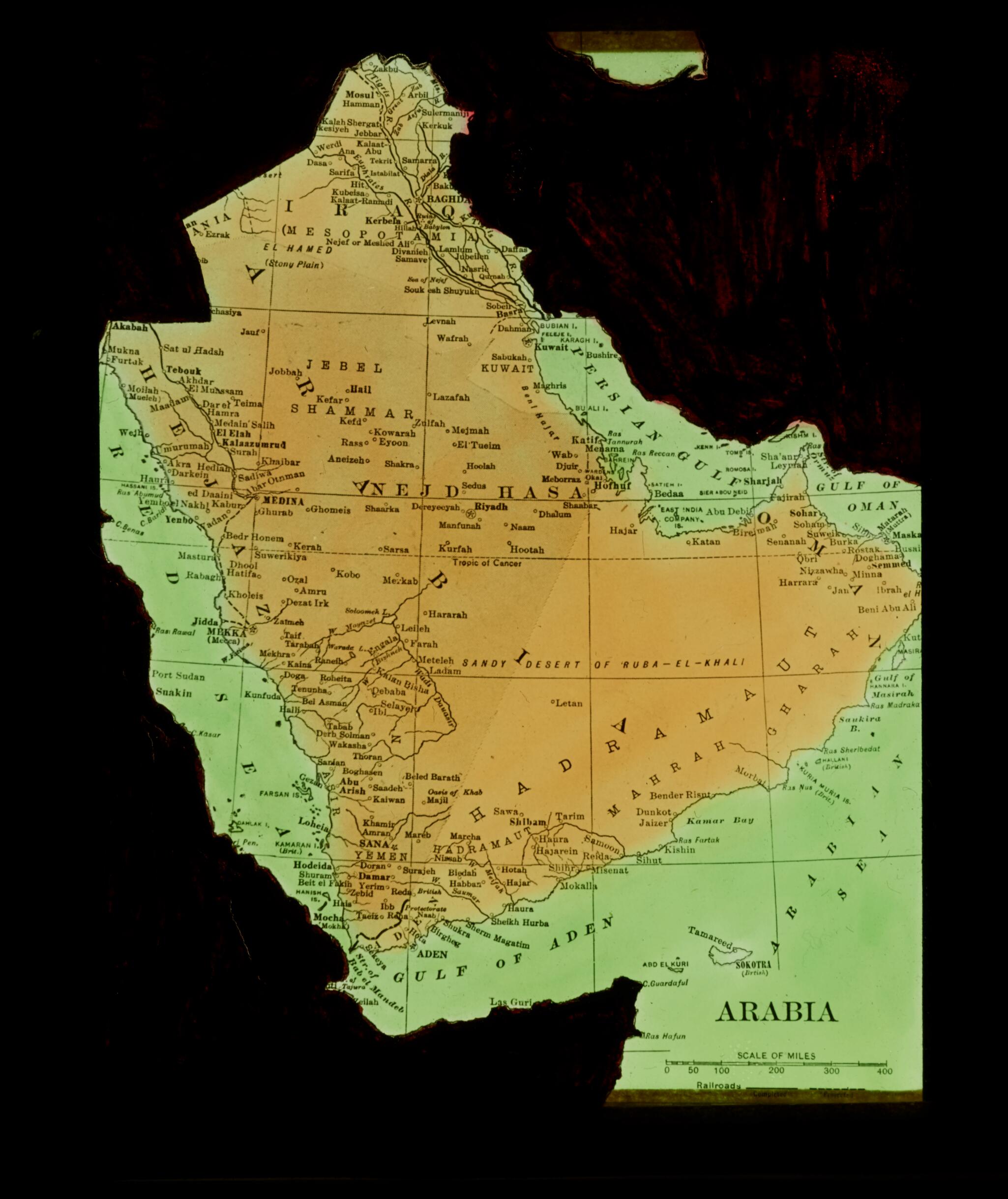
Map of the Arabian Peninsula 1915
- Regular price
-
$54.95 - Regular price
-
$30.95 - Sale price
-
$54.95
Buy one map, get any other map in our collection for 50% OFF! Add to cart to see discount.
Couldn't load pickup availability
About This Map
Discover the timeless beauty of our fine art quality printed reproduction of this antique map. Perfect for history enthusiasts, collectors, and interior decorators.
Restored with meticulous attention to detail by our team with over a decade of experience, this stunning reproduction captures the intricate artistry and historical significance of the original map.
Whether you're a collector or seeking a unique decor piece, this archival-quality map reproduction is a timeless addition to any space. Order now to bring history to life!
Old map of Bahrain, Iraq, Kuwait, Oman, Qatar, Saudi Arabia, United Arab Emirates, Yemen.18, an important theater of operations during World War I. By supporting the revolt against Ottoman Rule, the British sought to weaken the Ottoman Empire, which was aligned with Germany and Austria-Hungary. For their part, the Arabs hoped to secure independence and create a unified empire embracing the region from Aleppo, Syria to Aden, Yemen. This is the only map in the collection; the other 64 slides are photographs. The map is based on a 19th century commercially produced British map of Arabia (likely circa 1870 or earlier). The slide has been altered by painting over the areas showing Africa, Persia, and the Levant. The area left shows Arabia and the British mandate in Iraq though it excludes British Mandatory Palestine. The photographs depict many of the protagonists in this political and military struggle, including Colonel T.E. Lawrence of the British army and the British explorer and agent Harry Saint John Philby, as well as members of the house of Hashim Faisal bin Hussein and Abdullah bin Hussein, the key tribal leaders who led the revolt, and other prominent Arab leaders such as Dhari ibn Tawala of the Aslam Shammar and Sheikh Ibrahim of al-Zubayr. Other photographs depict unidentified Western agents and Arab tribal leaders. One of the women shown in the photographs most likely is Gertrude Bell of the British Military Intelligence Department. She played a key role in organizing the revolt and in gaining the support of Arab leaders. Other photographs depict desert scenes, Bedouin encampments in the Arabian Peninsula, and settlements along the riverbanks of the Shatt al-Arab. The diversity of settings reflects the fact that the Arab tribal confederations involved in the revolt included those from the heart of Arabia as well as those from the villages of Iraq. Some of the pictures most likely were postcards or reproductions and may have originated from the Basra Venus Photo Studio, which produced many views of the Shatt al-Arab. The photographs also include images of everyday village life, peasants with their laden donkeys, boat crews sailing the canals, and villagers in the marketplace. Also present are a few pictures representing religious and civil buildings. The collection was probably assembled for a lecture. The A.H. Roberts mentioned on the cover of the box containing the slides is most likely Lieutenant A.H. Roberts, the British assistant and political officer in al-Zubayr, a city located southwest of Basra, at the time of the British military occupation of Iraq. Lieutenant A.H. Roberts is mentioned by Saint John Philby in his The Heart of Arabia, when he describes his presence in al-Zubayr: "... by nightfall I was deposited at the door of the Assistant Political Officer of Zubair, Lieutenant A. H. Roberts, with whom I proceeded at once to the Shaikh's residence, whither we had been bidden for dinner." As reported in the same work, in 1917 a number of Arab tribal leaders gathered in al-Zubayr with British agents and officials to discuss the revolt.
- Title devised, in English, by Library staff.
- Original resource extent: 1 map : lantern slide, glass plate ; 9 x 10 centimeters.
- Reference extracted from World Digital Library: Harry St. John Bridger Philby, The Heart of Arabia: A Record of Travel and Exploration (London: Constable, 1922).
- Original resource at: Qatar National Library.
- Content in English.
- Description based on data extracted from World Digital Library, which may be extracted from partner institutions.
- For the best legibility, order your map in the original size or larger. Most maps have intricate detail and small text that is best appreciated when the print size hasn't been reduced.
- Sizes labeled "Fits a Standard Frame" will drop right into any frame that you purchase in that size. The sizes that we offer are commonly available online and at most retail stores.
- Our standard sizes are recommendations based on the aspect ratio of the original map, but still may require some added "white space" in one dimension to fit.
- Non-standard sizes will require custom framing, and we suggest taking your print to the frame shop of your choice after you receive it for the best results.
- Custom sizes are available, simply contact us for a quote.
Below is an approximation of the scale of a few standard sizes, and how they might appear in your space.

