
Map of the Atlantic Ocean, 1613
- Regular price
-
$56.95 - Regular price
-
$51.95 - Sale price
-
$56.95
Buy one map, get any other map in our collection for 50% OFF! Add to cart to see discount.
Couldn't load pickup availability
About This Map
Discover the timeless beauty of our fine art quality printed reproduction of this antique map. Perfect for history enthusiasts, collectors, and interior decorators.
Restored with meticulous attention to detail by our team with over a decade of experience, this stunning reproduction captures the intricate artistry and historical significance of the original map.
Whether you're a collector or seeking a unique decor piece, this archival-quality map reproduction is a timeless addition to any space. Order now to bring history to life!
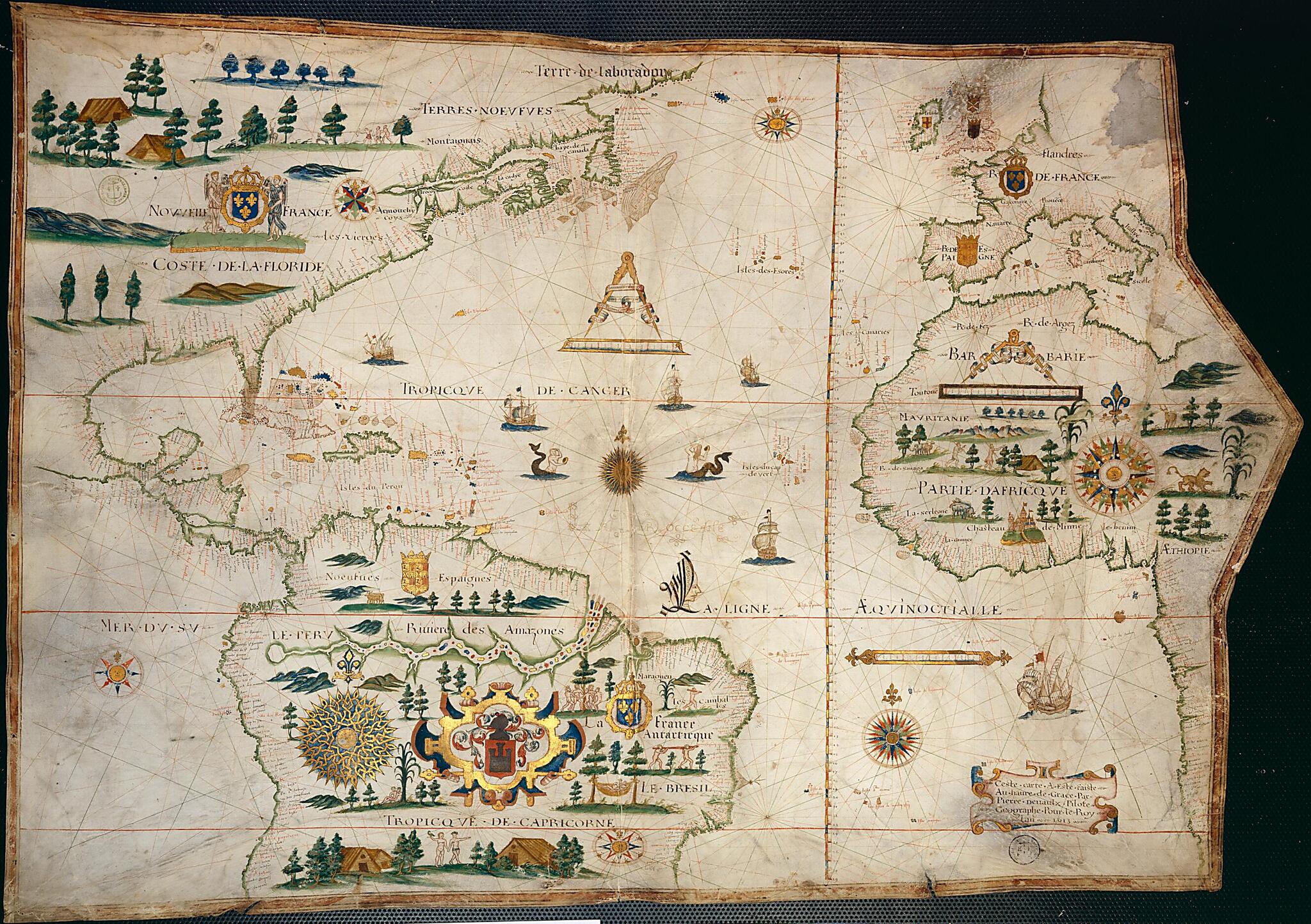
Audemer, settled in Le Havre soon after King François I founded the city in 1517. Jacques de Vaulx produced a compilation of contemporary works on nautical navigation entitled "Les premières oeuvres de Jacques de Vaulx," as well as a number of important maps. Pierre de Vaulx was the younger brother of Jacques; the map presented here is his sole extant work. It shows the coasts of Europe from L'Escaut (the Scheldt River) to the Dalmatian coast; Africa from Libya to Cape Fria (Namibia); and North and South America from Labrador to Rio de Janeiro on the Atlantic and from Acapulco to Anegada Point in Chile on the Pacific. The many decorative elements on the map include colored drawings of ships and mermaids on the sea and illustrations of people, houses, and animals on land. The map prominently shows the Amazon River and French Antarctica, a French colony that was established in Brazil in 1555 and that was later conquered by the Portuguese. The names of Indian tribes in New France (present-day Canada) are indicated, and include Montagnais, Iroquois, and others. The map is from the Navy Hydrographic Office Collection in the National Library of France, which was deposited in the library in several stages between 1942 and 1965. The collection derives from the French navy's General Repository of Maps and Plans, Journals and Memoirs, which was established by King Louis XV in 1720 in order to collect the documentation needed to produce reliable nautical maps.Created by Pierre De Vaulx in 1613.
- Title devised, in English, by Library staff.
- "Scale about 1:16,000,000"--Note extracted from World Digital Library.
- Original resource extent: 1 map : on vellum ; 96 x 68.5 centimeters.
- Reference extracted from World Digital Library: Sarah Toulouse, "Marine Cartography and Navigation in Renaissance France," in David Woodward, editor, The History of Cartography, vol. 3, Cartography in the European Renaissance (Chicago: University of Chicago Press, 2007).
- Original resource at: National Library of France.
- Content in French.
- Description based on data extracted from World Digital Library, which may be extracted from partner institutions.
Map Subjects
Animals
Atlantic Ocean
Devices (Heraldry)
Hunting
Indigenous Peoples
Manuscript Maps
Nautical Charts
Portolan Charts
Sailing Ships
Pierre De Vaulx
1613
- For the best legibility, order your map in the original size or larger. Most maps have intricate detail and small text that is best appreciated when the print size hasn't been reduced.
- Sizes labeled "Fits a Standard Frame" will drop right into any frame that you purchase in that size. The sizes that we offer are commonly available online and at most retail stores.
- Our standard sizes are recommendations based on the aspect ratio of the original map, but still may require some added "white space" in one dimension to fit.
- Non-standard sizes will require custom framing, and we suggest taking your print to the frame shop of your choice after you receive it for the best results.
- Custom sizes are available, simply contact us for a quote.
Below is an approximation of the scale of a few standard sizes, and how they might appear in your space.

