
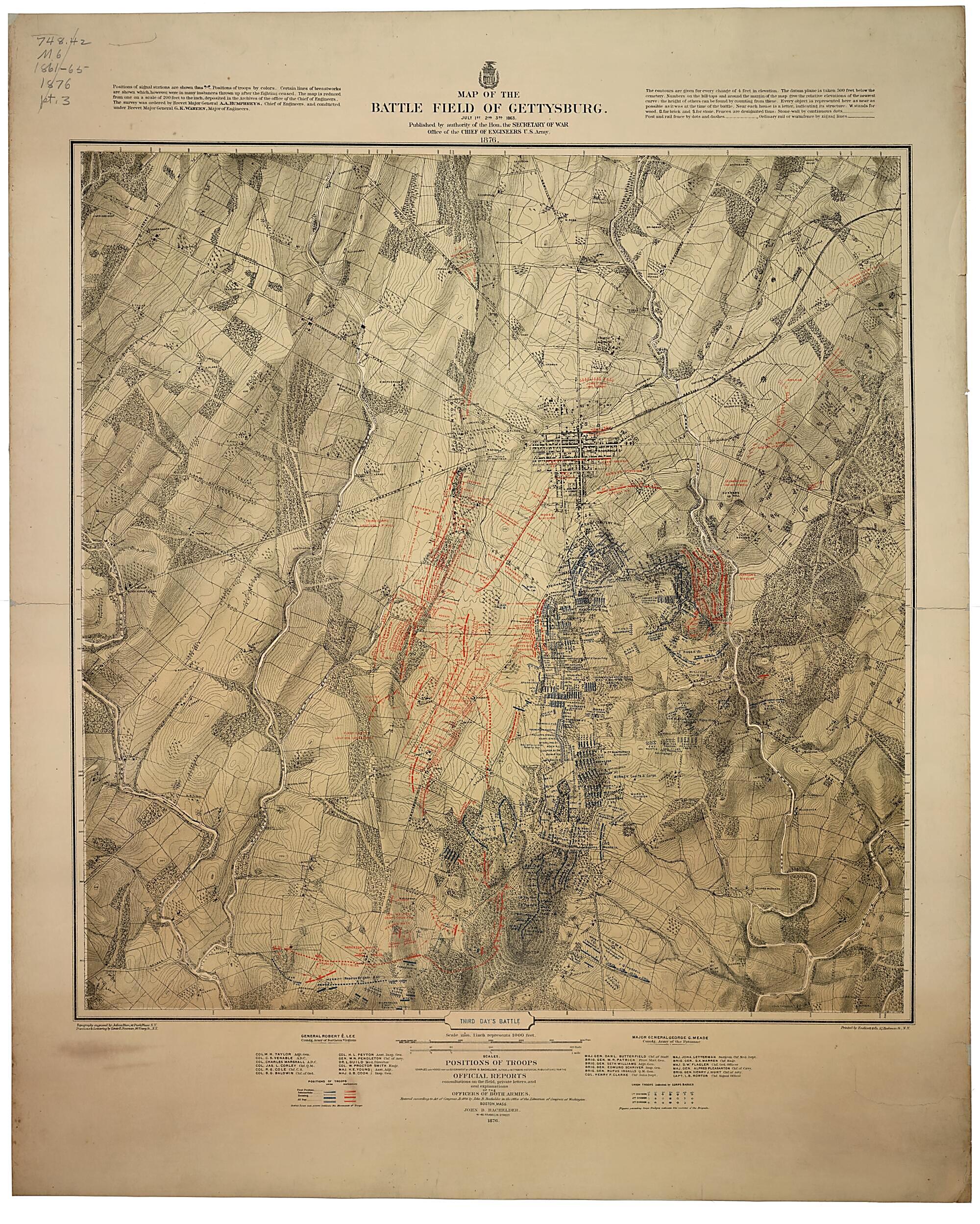
Map of the Battle Field of Gettysburg. July 1st, 2nd, 3rd, 1863 1876
- Regular price
-
$132.95 - Regular price
-
$127.95 - Sale price
-
$132.95
Buy one map, get any other map in our collection for 50% OFF! Add to cart to see discount.
Couldn't load pickup availability
About This Map
Discover the timeless beauty of our fine art quality printed reproduction of this antique map. Perfect for history enthusiasts, collectors, and interior decorators.
Restored with meticulous attention to detail by our team with over a decade of experience, this stunning reproduction captures the intricate artistry and historical significance of the original map.
Whether you're a collector or seeking a unique decor piece, this archival-quality map reproduction is a timeless addition to any space. Order now to bring history to life!
Old map of Gettysburg Region, Pennsylvania, United States.Created by John B. (John Badger) Bachelder, Julius Bien, Louis E. Neuman, United States. Army. Corps of Engineers in 1876.
- "Printed by Endicott & Co. . . . N.Y."
- "The map is reduced from one on a scale of 200 feet to the inch, deposited in the Archives of the office of the Chief of Engineers. The survey was ordered by Brevet Major General A. A. Humphreys, Chief of Engineers, and conducted under Brevet Major General G. K. Warren, Major of Engineers."
- "Topography engraved by Julius Bien . . . N.Y. Positions & lettering by Louis E. Neuman . . . N.Y."
- A very minute analysis of the deployment of the various units of both armies, with the names of commanding officers, period of time spent in a particular position, and other pertinent information is given. Dotted lines and arrows indicate the movements of the troops, and the positions at various times of the day are shown by symbols explained in the legend.
- An extremely detailed topographic map with spot elevations and contours "given for every change of 4 feet in elevation." Drainage, vegetation, roads, railroads, fences, houses with names of residents, and a detailed plan of the town of Gettysburg are shown. "Every object is represented here as near as possible as it was at the time of the battle."
- Description derived from published bibliography.
- Relief shown by form lines and shading.
- The maps are entitled: First day's battle. Second day's battle. Third day's battle.
- This item is in the Map Collection of the Library of Virginia; please contact the Library's Archives Research Services department for more information.
- Scale 1:12,000.
- Civil War Map
- Oct. 2002; c. 1, maps 1-3; Misses Anna B. and Ellen P. Baykin (May 1928), gifts; c. 2, map 1 photocopy, LVA; c. 3, map 1 photocopy, LVA, Map Cataloging Team.
- Civil War Map Proj. no.: LVA00067.
- Conservation: Etherington Conservation Center, July 2002.
- LVA accession no.: 5191X.
- Map accession no. 5190X; c. 2 (positive photostat, on sheet 77 x 61 cm.); c. 3 (negative photostat, on sheet 76 x 59 cm.).
- Previously filed as: 748.42 M6 1861-1865 1876.
Map Subjects
Gettysburg Region
Gettysburg Region (Pa.)
Gettysburg Battle Of Gettysburg Pa.
Pennsylvania
United States
John B. (John Badger) Bachelder
Julius Bien
Louis E. Neuman
United States. Army. Corps Of Engineers
1876
- For the best legibility, order your map in the original size or larger. Most maps have intricate detail and small text that is best appreciated when the print size hasn't been reduced.
- Sizes labeled "Fits a Standard Frame" will drop right into any frame that you purchase in that size. The sizes that we offer are commonly available online and at most retail stores.
- Our standard sizes are recommendations based on the aspect ratio of the original map, but still may require some added "white space" in one dimension to fit.
- Non-standard sizes will require custom framing, and we suggest taking your print to the frame shop of your choice after you receive it for the best results.
- Custom sizes are available, simply contact us for a quote.
Below is an approximation of the scale of a few standard sizes, and how they might appear in your space.

