
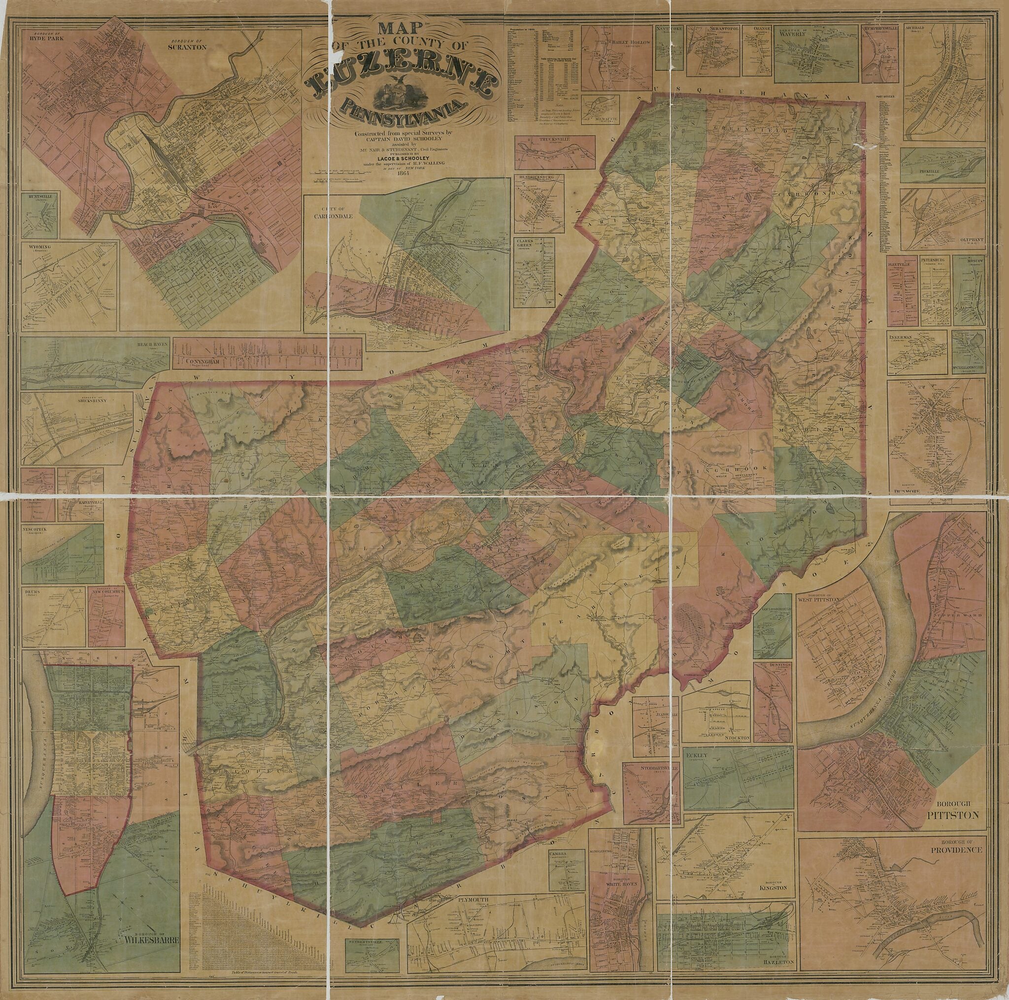
Map of the County of Luzerne, Pennsylvania in 1864
- Regular price
-
$198.95 - Regular price
-
$193.95 - Sale price
-
$198.95
Buy one map, get any other map in our collection for 50% OFF! Add to cart to see discount.
Couldn't load pickup availability
About This Map
Discover the timeless beauty of our fine art quality printed reproduction of this antique map. Perfect for history enthusiasts, collectors, and interior decorators.
Restored with meticulous attention to detail by our team with over a decade of experience, this stunning reproduction captures the intricate artistry and historical significance of the original map.
Whether you're a collector or seeking a unique decor piece, this archival-quality map reproduction is a timeless addition to any space. Order now to bring history to life!
Old map of Barre, Carbondale, Hazleton, Kingston, Lackawanna County, Luzerne County, Pennsylvania, Pittston, Plymouth, Scranton, United States, Wilkes, Barre.Created by Lacoe & Schooley, McNair & Sturdevant, David Schooley, Henry Francis Walling in 1864.
- General-content county map showing rural buildings and householders' names; some inset maps show building coverage and owners' names.
- Hand col. to distinguish minor civil divisions (townships, boroughs, cities).
- Relief shown by hachures and spot heights.
- Also covers Lackawanna County (detached from the northern part of Luzerne County in 1878).
- Title from 2nd sheet.
- Land Ownership Map
- Includes note, population table, table of anthracite production, table of road distances, and post-office list.
- Insets: Borough of Scranton, borough of Hyde Park -- City of Carbondale -- Clarks Green (Abington) -- Hendricksburg -- Trucksville (Kingston) -- Milwaukie (Newtown) -- Bailey Hollow (Abington) -- Nanticoke (Hanover) -- Sebastopol (Jenkins) -- Orange (Franklin) -- Borough of Waverly -- Humphreysville (Abingdon) -- Archbald (Blakely) -- Peckville (Blakely) -- Olyphant (Blakely) -- Fleetville (Benton) -- Petersburg (Scranton Bor.) -- Moscow (Madison) -- Inkerman (Jenkins) -- McClellandsville (Dallas P.O.) -- Borough of Dunmore -- Borough of Pittston, borough of West Pittston -- Borough of Providence -- Gouldsborough (Buck) -- Stockton (Hazle) -- Eckley (Foster) -- Borough of Kingston -- Borough of Hazleton -- Jeansville (Hazle) -- Stoddartsville (Buck) -- Borough of White Haven, Middleburg -- Cambra (Huntington) -- Plymouth -- Seybertsville (Sugar Loaf) -- Borough of Wilkesbarre -- Drums (Butler) -- Borough of New Columbus -- Nescopeck (Nescopeck) -- Town Hill (Huntingron) -- Harveyville (Huntington) -- Borough of Shickshinny -- Beach Haven (Salem) -- Conyngham (Sugar Loaf) -- Wyoming (Kingston) -- Huntsville (Jackson).
- 2 copies
Map Subjects
Carbondale
Carbondale (Pa.)
Hazleton
Hazleton (Pa.)
Kingston (Luzerne County Pa.)
Lackawanna County
Lackawanna County (Pa.)
Landowners
Luzerne County
Luzerne County (Pa.)
Pennsylvania
Pittston
Pittston (Pa.)
Plymouth
Plymouth (Pa.)
Scranton
Scranton (Pa.)
United States
Barre
Barre (Pa.)
Kingston
Wilkes
Lacoe & Schooley
McNair & Sturdevant
David Schooley
Henry Francis Walling
1864
- For the best legibility, order your map in the original size or larger. Most maps have intricate detail and small text that is best appreciated when the print size hasn't been reduced.
- Sizes labeled "Fits a Standard Frame" will drop right into any frame that you purchase in that size. The sizes that we offer are commonly available online and at most retail stores.
- Our standard sizes are recommendations based on the aspect ratio of the original map, but still may require some added "white space" in one dimension to fit.
- Non-standard sizes will require custom framing, and we suggest taking your print to the frame shop of your choice after you receive it for the best results.
- Custom sizes are available, simply contact us for a quote.
Below is an approximation of the scale of a few standard sizes, and how they might appear in your space.

