
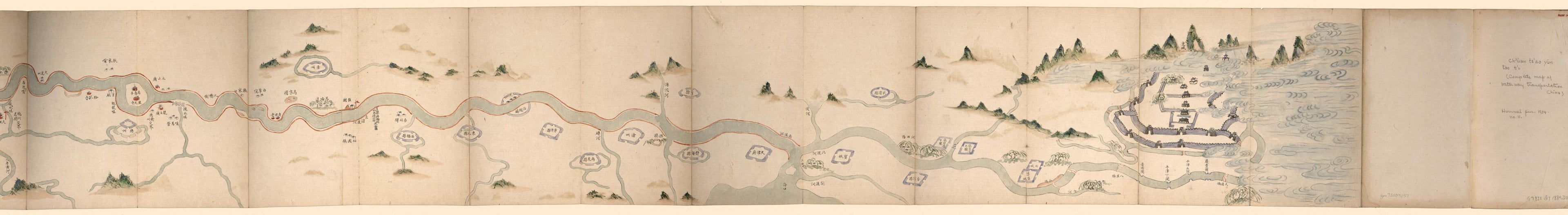
全漕運道圖 /, Map of the Grand Canal Water Course in 1884
- Regular price
-
$209.95 - Regular price
-
$204.95 - Sale price
-
$209.95
Shipping calculated at checkout.
Buy one map, get any other map in our collection for 50% OFF! Add to cart to see discount.
Couldn't load pickup availability
About This Map
Old map of China, Grand Canal, Yangtze River.
Created by Bikui Duan, Arthur W. (Arthur William) Hummel in 1884.
Created by Bikui Duan, Arthur W. (Arthur William) Hummel in 1884.
- Relief shown pictorially.
- Title from cover.
- Oriented with north to the right.
- Shows combined waterways, points of interest, and dikes of the Grand Canal and the Yangtze River from Beijing via Yangzhou to Dongting Lake in Hunan.
- Gift; Arthur William Hummel; 1934, no. 11.
Map Sizing Information
- For the best legibility, order your map in the original size or larger. Most maps have intricate detail and small text that is best appreciated when the print size hasn't been reduced.
- Sizes labeled "Fits a Standard Frame" will drop right into any frame that you purchase in that size. The sizes that we offer are commonly available online and at most retail stores.
- Our standard sizes are recommendations based on the aspect ratio of the original map, but still may require some added "white space" in one dimension to fit.
- Non-standard sizes will require custom framing, and we suggest taking your print to the frame shop of your choice after you receive it for the best results.
- Custom sizes are available, simply contact us for a quote.
Below is an approximation of the scale of a few standard sizes, and how they might appear in your space.
