
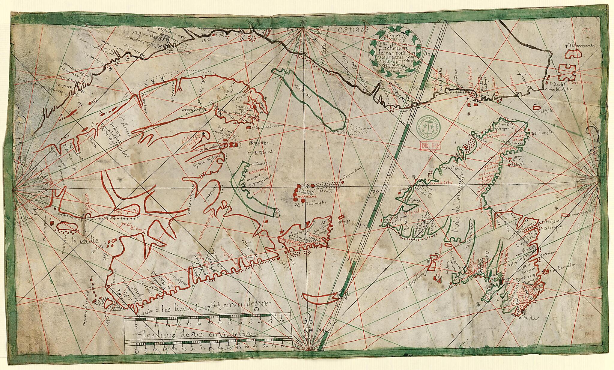
Map of the Island of Newfoundland, 1689
- Regular price
-
$54.95 - Regular price
-
$33.95 - Sale price
-
$54.95
Buy one map, get any other map in our collection for 50% OFF! Add to cart to see discount.
Couldn't load pickup availability
About This Map
Discover the timeless beauty of our fine art quality printed reproduction of this antique map. Perfect for history enthusiasts, collectors, and interior decorators.
Restored with meticulous attention to detail by our team with over a decade of experience, this stunning reproduction captures the intricate artistry and historical significance of the original map.
Whether you're a collector or seeking a unique decor piece, this archival-quality map reproduction is a timeless addition to any space. Order now to bring history to life!
Old map of Canada, New Brunswick, Newfoundland and Labrador, Nova Scotia, Prince Edward Island, Quebec.day Placentia, Newfoundland, Canada), the French capital of Newfoundland, for Governor Antoine Parat. It contains many place-names in the Basque language and details the many anchorages along the coast between Newfoundland and Tadoussac (present-day Quebec). Along with the Portuguese, the Basques were early arrivals to the fishing grounds off the coast of Newfoundland. They began whaling and fishing for cod in these waters around 1525. Their method was to sail to North America in the spring and to return to their homeports in the Bay of Biscay in December or January, when ice conditions in the North Atlantic worsened. By the late 17th century, when this map was made, French fishermen and sailors, many of them Basques, had been plying these waters for more than 150 years. The scale is given in lieus (leagues), an old French measurement that varied by degrees and time; very approximately, one lieu = three kilometers. The map is from the Navy Hydrographic Office Collection in the National Library of France, which was deposited in the library in several stages between 1942 and 1965. The collection derives from the French navy's General Repository of Maps and Plans, Journals and Memoirs, which was established by King Louis XV in 1720 in order to collect the documentation needed to produce reliable nautical maps.
Created by Pierre Detcheverry in 1689.
- Title devised, in English, by Library staff.
- Original resource extent: 1 map : manuscript, color on parchment ; 32.5 x 57 centimeters.
- Reference extracted from World Digital Library: René Baudry, "Parat, Antoine," in Dictionary of Canadian Biography 1 (Toronto: University of Toronto/Université Laval, 2003-- ).|"Basques," The Canadian Encyclopedia, http://www.thecanadianencyclopedia.ca/en/article/basques/ External
- Original resource at: National Library of France.
- Content in Basque and French.
- Description based on data extracted from World Digital Library, which may be extracted from partner institutions.
Map Subjects
Canada
Manuscript Maps
Nautical Charts
New Brunswick
Newfoundland And Labrador
Nova Scotia
Parat Antoine 1696
Portolan Charts
Prince Edward Island
Quebec
Pierre Detcheverry
1689
- For the best legibility, order your map in the original size or larger. Most maps have intricate detail and small text that is best appreciated when the print size hasn't been reduced.
- Sizes labeled "Fits a Standard Frame" will drop right into any frame that you purchase in that size. The sizes that we offer are commonly available online and at most retail stores.
- Our standard sizes are recommendations based on the aspect ratio of the original map, but still may require some added "white space" in one dimension to fit.
- Non-standard sizes will require custom framing, and we suggest taking your print to the frame shop of your choice after you receive it for the best results.
- Custom sizes are available, simply contact us for a quote.
Below is an approximation of the scale of a few standard sizes, and how they might appear in your space.
