
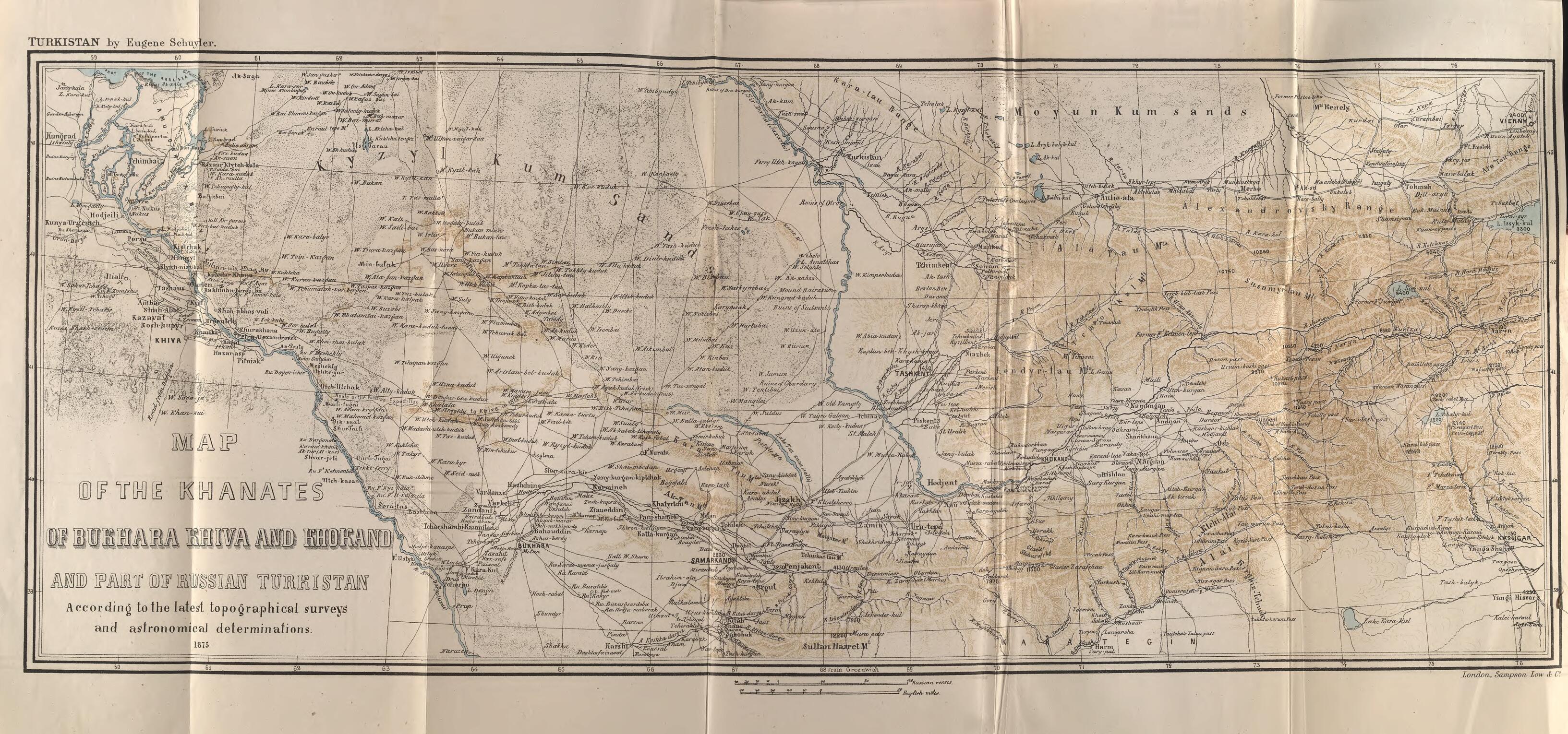
Map of the Khanates of Bukhara, Khiva, and Khokand and Part of Russian Turkistan 1875
- Regular price
-
$49.95 - Regular price
-
$34.95 - Sale price
-
$49.95
Buy one map, get any other map in our collection for 50% OFF! Add to cart to see discount.
Couldn't load pickup availability
About This Map
Discover the timeless beauty of our fine art quality printed reproduction of this antique map. Perfect for history enthusiasts, collectors, and interior decorators.
Restored with meticulous attention to detail by our team with over a decade of experience, this stunning reproduction captures the intricate artistry and historical significance of the original map.
Whether you're a collector or seeking a unique decor piece, this archival-quality map reproduction is a timeless addition to any space. Order now to bring history to life!
Old map of Kazakhstan, Tajikistan, Turkmenistan, Uzbekistan.generalship of the Russian Empire established in 1867, two years after the start of the Russian conquest of the region of Central Asia known as Turkestan. This map of these territories, comprising parts of present-day Kazakhstan, Tajikistan, Turkmenistan, and Uzbekistan, was made by Eugene Schuyler (1840--90), an American diplomat, explorer, author, and scholar who was one of the first foreigners invited by the Russian government to see Russia's newly conquered territories. In 1873, while serving as the secretary of the American legation in Saint Petersburg, Schuyler made an eight-month trip through lands then little known to outsiders. He gathered extensive geographical information and wrote accounts of his travels for the National Geographic Society and a lengthy confidential report for the U.S. Department of State. He was critical of Russian treatment of the Tartars but otherwise saw the Russian presence in Central Asia as benign. Schuyler's map was printed separately in 1875 and included in his two-volume work, Turkistan: Notes of a Journey in Russian Turkistan, Khokand, Bikhara, and Kuldja, which was published in 1876 in the United States and Britain.
Created by Eugene Schuyler in 1875.
- Title devised, in English, by Library staff.
- Original resource at: National Library of Kazakhstan.
- Content in English.
- Description based on data extracted from World Digital Library, which may be extracted from partner institutions.
- For the best legibility, order your map in the original size or larger. Most maps have intricate detail and small text that is best appreciated when the print size hasn't been reduced.
- Sizes labeled "Fits a Standard Frame" will drop right into any frame that you purchase in that size. The sizes that we offer are commonly available online and at most retail stores.
- Our standard sizes are recommendations based on the aspect ratio of the original map, but still may require some added "white space" in one dimension to fit.
- Non-standard sizes will require custom framing, and we suggest taking your print to the frame shop of your choice after you receive it for the best results.
- Custom sizes are available, simply contact us for a quote.
Below is an approximation of the scale of a few standard sizes, and how they might appear in your space.
