
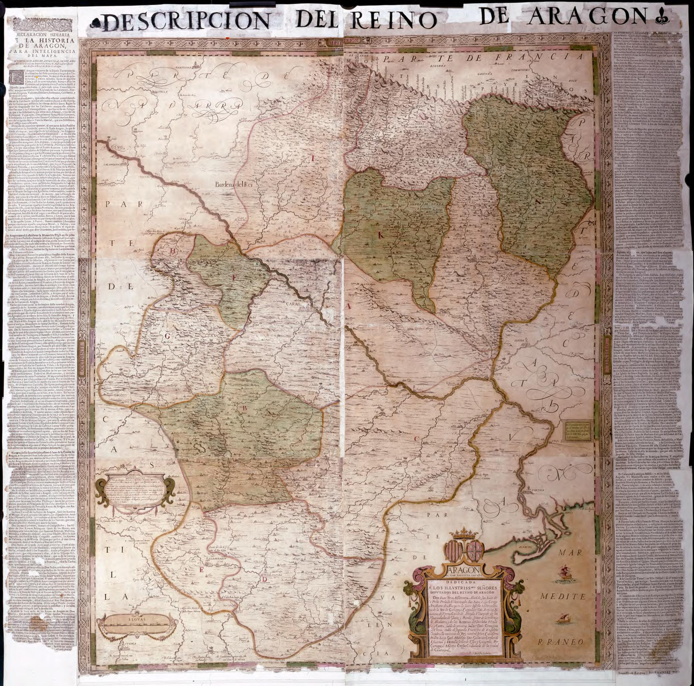
Map of the Kingdom of Aragon by Juan Bautista Labaña. (Aragón De Ioan Baptista Lavaña) 1675
- Regular price
-
$49.95 - Regular price
-
$34.95 - Sale price
-
$49.95
Buy one map, get any other map in our collection for 50% OFF! Add to cart to see discount.
Couldn't load pickup availability
About This Map
Discover the timeless beauty of our fine art quality printed reproduction of this antique map. Perfect for history enthusiasts, collectors, and interior decorators.
Restored with meticulous attention to detail by our team with over a decade of experience, this stunning reproduction captures the intricate artistry and historical significance of the original map.
Whether you're a collector or seeking a unique decor piece, this archival-quality map reproduction is a timeless addition to any space. Order now to bring history to life!
Old map of Aragón, Spain.and 18th-century Spanish cartography. It became the basis for all subsequent maps of the region, and is the only one that was made using direct measurement and surveys. The map was created by order of the Deputation of the Kingdom of Aragon by cartographer Juan Bautista Labaña (1555--1624), who employed the triangulation method. In 1610--15, Labaña travelled around the country making the necessary observations from vertices established in towers and on mountain peaks. He described these researches in his Itinerario del Reino de Aragón (Itinerary of the Kingdom of Aragon), where he recorded all the readings used to create the map, the manuscript of which is preserved in the Leiden University library. The map was printed in Madrid on six copper plates in 1619--20. The style of drawing is sober, far removed from the ostentation and aestheticism of contemporary maps published in the Netherlands. Labaña represented the essential elements of the territory clearly and used easy-to-read calligraphy. Only two versions of the map are known to exist: the first is the original, drawn by Labaña and printed by Diego de Astor in 1617--20, from which several copies were made, and a second one that was corrected and enhanced by Tomas Fermin de Lezaun in 1777. The National Library of Spain copy is a print of Labaña's original plate, although with accompanying text by Lupercio Leonardo de Argensola added in the late 17th century by Aragonese printer Pascual Bueno. Labaña was born in Lisbon and was a mathematics teacher for King Don Sebastián. After Portugal was joined to the Spanish crown in 1580, he moved to Madrid, where he lived most of his life. In 1582, he was named professor in the Academy of Sciences, where he taught mathematics, cosmography, and geography. Labaña tutored the sons and nephews of King Philip III of Spain, who also named him senior cartographer and chronicler of the kingdom. The author of the accompanying text, the Spanish writer Argensola, was born in Huesca in 1559 and died in Naples in 1612. In 1599, Philip III named him senior chronicler to the crown of Aragon. Among his works were Anales de la historia de Aragón (Milestones of the history of Aragon) and the Declaración sumaria de la historia de Aragón (Summary declaration of the history of Aragon), which was used to complete the geographical information in this map.
Created by João Baptista Lavanha, Lupercio Leonardo De Argensola in 1675.
- Title devised, in English, by Library staff.
- "Scale 1:276,000. 5 leagues = 11.5 centimeters. Graduated margins. Relief shown by outlined mountains."--Note extracted from World Digital Library.
- Original resource extent: 1 map on 2 sheets: print, color. 122 x 112 centimeters.
- Original resource at: National Library of Spain.
- Content in Spanish.
- Description based on data extracted from World Digital Library, which may be extracted from partner institutions.
- For the best legibility, order your map in the original size or larger. Most maps have intricate detail and small text that is best appreciated when the print size hasn't been reduced.
- Sizes labeled "Fits a Standard Frame" will drop right into any frame that you purchase in that size. The sizes that we offer are commonly available online and at most retail stores.
- Our standard sizes are recommendations based on the aspect ratio of the original map, but still may require some added "white space" in one dimension to fit.
- Non-standard sizes will require custom framing, and we suggest taking your print to the frame shop of your choice after you receive it for the best results.
- Custom sizes are available, simply contact us for a quote.
Below is an approximation of the scale of a few standard sizes, and how they might appear in your space.

