
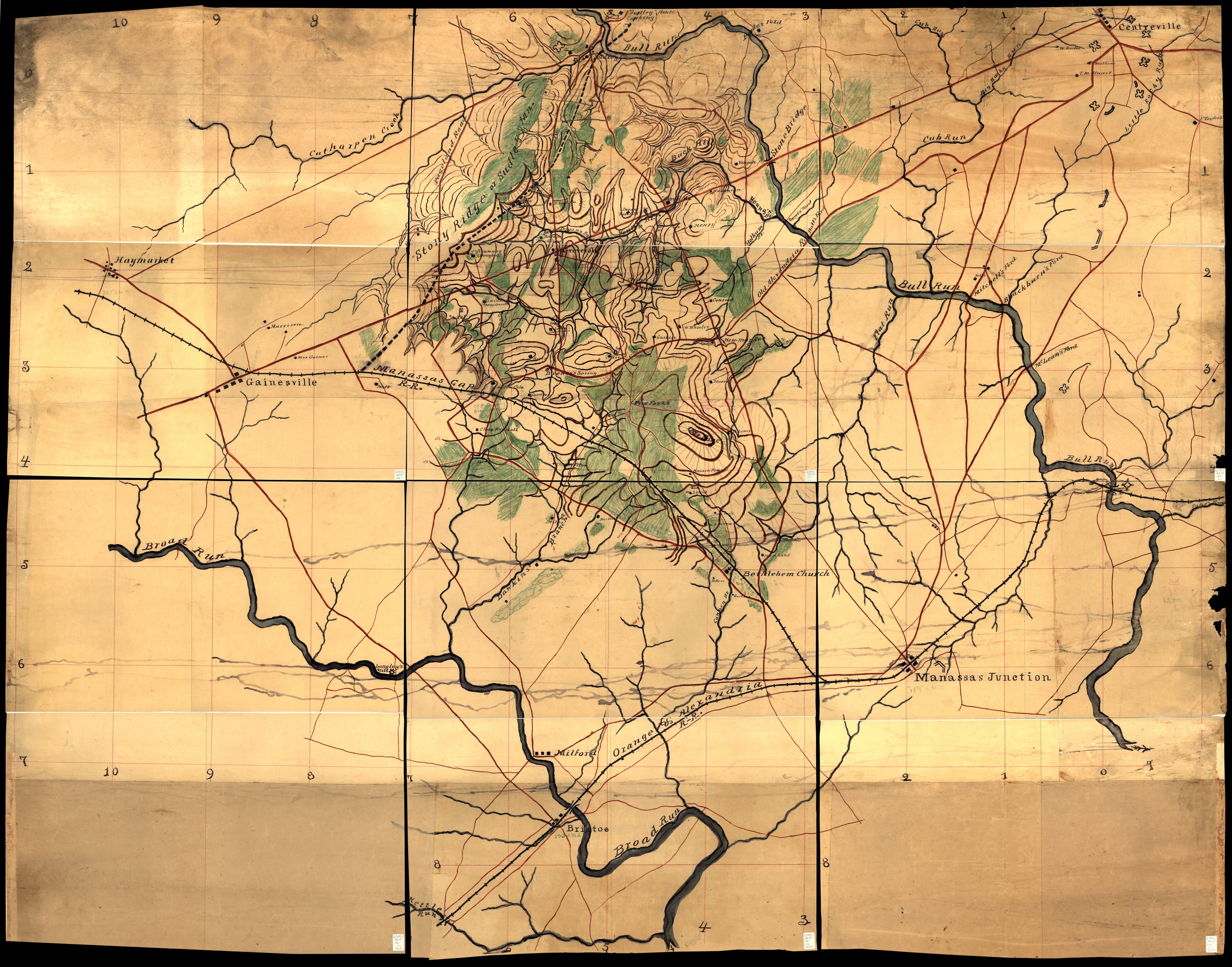
Map of the Manassas Battlefield Area In Northern Virginia in 1860
- Regular price
-
$227.95 - Regular price
-
$222.95 - Sale price
-
$227.95
Buy one map, get any other map in our collection for 50% OFF! Add to cart to see discount.
Couldn't load pickup availability
About This Map
Discover the timeless beauty of our fine art quality printed reproduction of this antique map. Perfect for history enthusiasts, collectors, and interior decorators.
Restored with meticulous attention to detail by our team with over a decade of experience, this stunning reproduction captures the intricate artistry and historical significance of the original map.
Whether you're a collector or seeking a unique decor piece, this archival-quality map reproduction is a timeless addition to any space. Order now to bring history to life!
Old topographic map / manuscript map of Manassas Region, United States, Virginia.Created by Jedediah Hotchkiss in 1860.
- Shows roads, railroads, fortifications, settlements, farmhouses with owners' names, and woodlands. Does not show troop positions or movements.
- Relief shown by contours (10-ft. intervals), hachures, form lines, and spot heights.
- Wall map believed to have been used by the author after the Civil War for lecture purposes.
- Signed in ms. on verso.
- Title from R.W. Stephenson's Civil War maps, 2nd ed., 1989.
- Pen-and-ink (red/black [broad nib]), watercolors, and col. pencils (blue/green/brown).
- Originally drawn on 9 sheets.
- This map has some imperfections: sheets halved, mounted on cloth backing, darkened, missing small sections at right edge. We'll do our best to restore the image before printing.
- Civil War Map
- Includes index[?] grid numbers at ends of red grid lines.
- For the best legibility, order your map in the original size or larger. Most maps have intricate detail and small text that is best appreciated when the print size hasn't been reduced.
- Sizes labeled "Fits a Standard Frame" will drop right into any frame that you purchase in that size. The sizes that we offer are commonly available online and at most retail stores.
- Our standard sizes are recommendations based on the aspect ratio of the original map, but still may require some added "white space" in one dimension to fit.
- Non-standard sizes will require custom framing, and we suggest taking your print to the frame shop of your choice after you receive it for the best results.
- Custom sizes are available, simply contact us for a quote.
Below is an approximation of the scale of a few standard sizes, and how they might appear in your space.

