
Map of the North Atlantic Ocean, 1674
- Regular price
-
$75.95 - Regular price
-
$70.95 - Sale price
-
$75.95
Buy one map, get any other map in our collection for 50% OFF! Add to cart to see discount.
Couldn't load pickup availability
About This Map
Discover the timeless beauty of our fine art quality printed reproduction of this antique map. Perfect for history enthusiasts, collectors, and interior decorators.
Restored with meticulous attention to detail by our team with over a decade of experience, this stunning reproduction captures the intricate artistry and historical significance of the original map.
Whether you're a collector or seeking a unique decor piece, this archival-quality map reproduction is a timeless addition to any space. Order now to bring history to life!
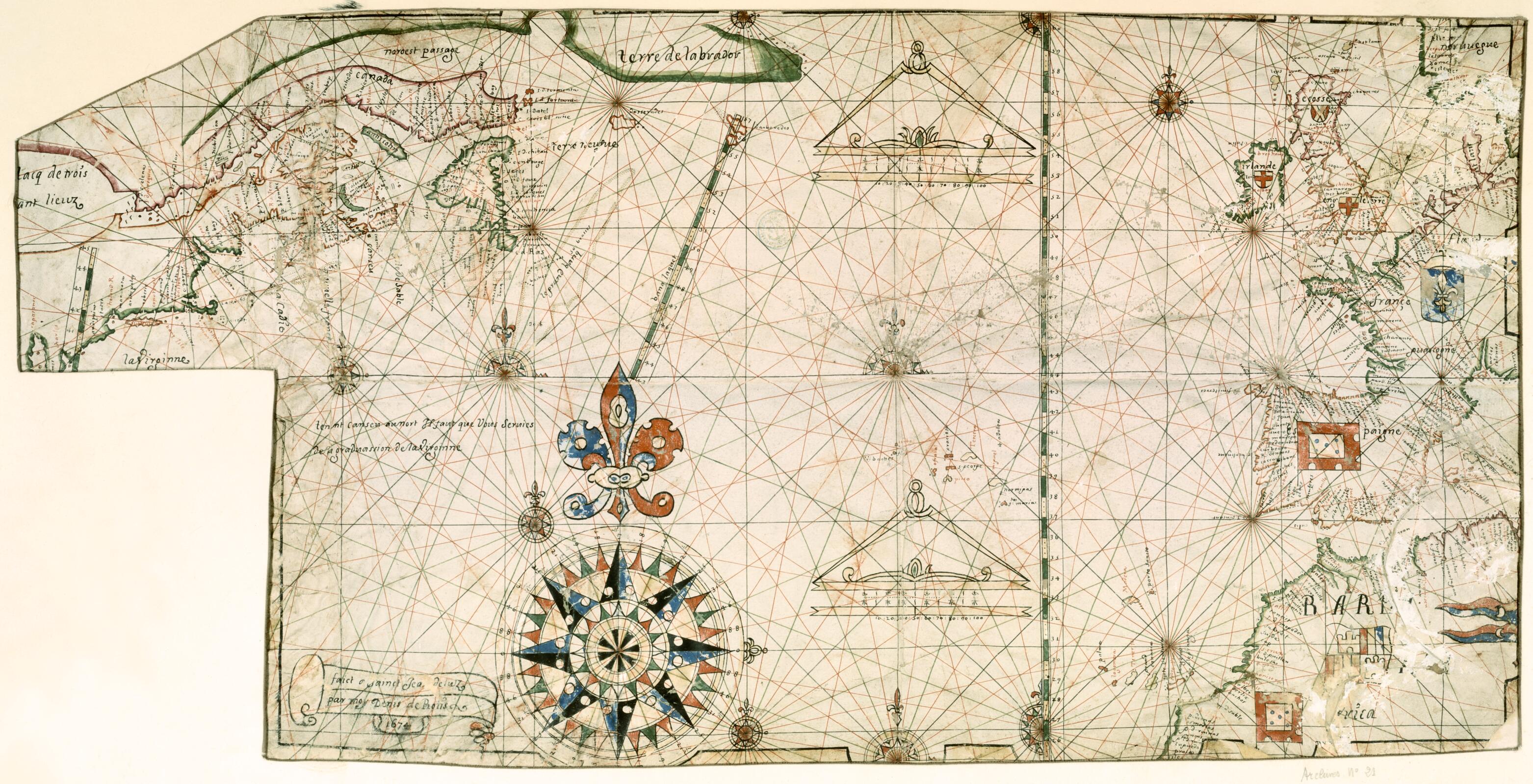
Old map of Canada, United States of America.17th century. Geographers quickly seized upon this hypothetical Western Sea and gave it a cartographic life. The de L'Isle family was at the heart of this geographic illusion. Denis de Rotis, a Basque pilot from Saint-Jean de Luz, was convinced of the existence of a Northwest Passage. On this 1674 portolan chart, he represented the passage as being north of, and parallel to, the Saint Lawrence River. Made for navigational purposes, the map uses the traditional network of rhumb lines corresponding to the 32 directions of the compass. It shows the Atlantic coast of the northeastern United States from Virginia to Spain, and the coast of Canada as far north as Labrador. The inscription on the lower left reads: Faict à Sainct Jean de Luz par Moy Denis de Rotis 1674 (Made at Saint-Jean de Luz by me, Denis de Rotis, 1674). Basque navigators were responsible for many early maps of the North Atlantic. Along with the Portuguese, the Basques were early arrivals to the fishing grounds off the coast of Newfoundland. They began whaling and fishing for cod in these waters around 1525. Their method was to sail to North America in the spring and to return to their homeports in the Bay of Biscay in December or January, when ice conditions in the North Atlantic worsened.
Created by Denis De Rotis in 1674.
- Title devised, in English, by Library staff.
- Original resource extent: 1 map : manuscript, illuminated on vellum ; 43.5 x 88 centimeters.
- Original resource at: National Library of France.
- Content in French.
- Description based on data extracted from World Digital Library, which may be extracted from partner institutions.
- For the best legibility, order your map in the original size or larger. Most maps have intricate detail and small text that is best appreciated when the print size hasn't been reduced.
- Sizes labeled "Fits a Standard Frame" will drop right into any frame that you purchase in that size. The sizes that we offer are commonly available online and at most retail stores.
- Our standard sizes are recommendations based on the aspect ratio of the original map, but still may require some added "white space" in one dimension to fit.
- Non-standard sizes will require custom framing, and we suggest taking your print to the frame shop of your choice after you receive it for the best results.
- Custom sizes are available, simply contact us for a quote.
Below is an approximation of the scale of a few standard sizes, and how they might appear in your space.
