
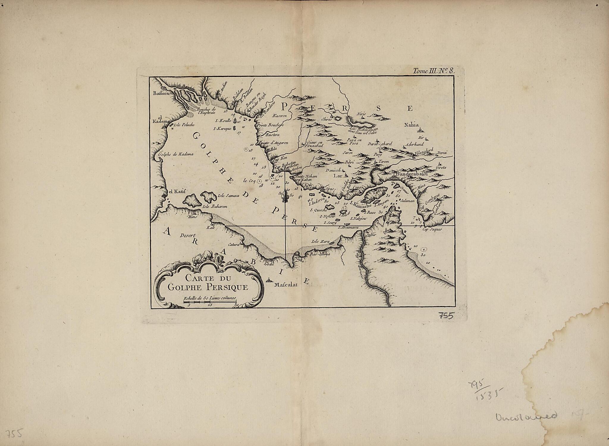
Map of the Persian Gulf. (Carte Du Golphe Persique) 1763
- Regular price
-
$57.95 - Regular price
-
$40.95 - Sale price
-
$57.95
Buy one map, get any other map in our collection for 50% OFF! Add to cart to see discount.
Couldn't load pickup availability
About This Map
Discover the timeless beauty of our fine art quality printed reproduction of this antique map. Perfect for history enthusiasts, collectors, and interior decorators.
Restored with meticulous attention to detail by our team with over a decade of experience, this stunning reproduction captures the intricate artistry and historical significance of the original map.
Whether you're a collector or seeking a unique decor piece, this archival-quality map reproduction is a timeless addition to any space. Order now to bring history to life!
Old map of Bahrain, Iran, Islamic Republic of, Iraq, Kuwait, Oman, Qatar, Saudi Arabia, United Arab Emirates.Nicolas Bellin (1703-72). Qatar is shown as Catura. Cities on both the Arabian and Persian sides of the gulf are indicated, and the map shows a river emptying into the gulf at the port of Julfar (present-day Ra's al-Khaymah, United Arab Emirates). The scale is in common leagues, and there are no latitudinal or longitudinal lines. Trained as a hydrographer, Bellin was attached to the French Marine Office and specialized in producing maritime maps showing coastlines. His maps were in the tradition of Nicolas Sanson (1600--1667), the royal geographer to Kings Louis XIII and Louis XIV commonly known as the father of French cartography, and of Guillaume de l'Isle (1675-1726), one of a group of French cartographers that wrested mapmaking preeminence from the Dutch in the late 17th century. Like Sanson and de l'Isle, Bellin placed great emphasis on scientific accuracy rather than on artistic beauty for its own sake. In 1764, he published Le Petit Atlas Maritime: Recueil de Cartes et de Plans des Quatre Parties du Monde (Small maritime atlas: collection of maps and charts of the four parts of the world), a work in five volumes containing 581 maps. This map appeared as plate 8 in volume 3 of this work, containing maps of Asia (part I) and Africa (part II).
Created by Nicolas in 1763.
- Title devised, in English, by Library staff.
- Original resource extent: 1 map : copper engraving ; 22 x 17 centimeters.
- Original resource at: Qatar National Library.
- Content in French.
- Description based on data extracted from World Digital Library, which may be extracted from partner institutions.
Map Subjects
Arabian Gulf
Arabian Peninsula
Bahrain
Iran Islamic Republic Of
Iraq
Kuwait
Nautical Charts
Oman
Persian Gulf
Qatar
Saudi Arabia
United Arab Emirates
Nicolas
1763
- For the best legibility, order your map in the original size or larger. Most maps have intricate detail and small text that is best appreciated when the print size hasn't been reduced.
- Sizes labeled "Fits a Standard Frame" will drop right into any frame that you purchase in that size. The sizes that we offer are commonly available online and at most retail stores.
- Our standard sizes are recommendations based on the aspect ratio of the original map, but still may require some added "white space" in one dimension to fit.
- Non-standard sizes will require custom framing, and we suggest taking your print to the frame shop of your choice after you receive it for the best results.
- Custom sizes are available, simply contact us for a quote.
Below is an approximation of the scale of a few standard sizes, and how they might appear in your space.

