
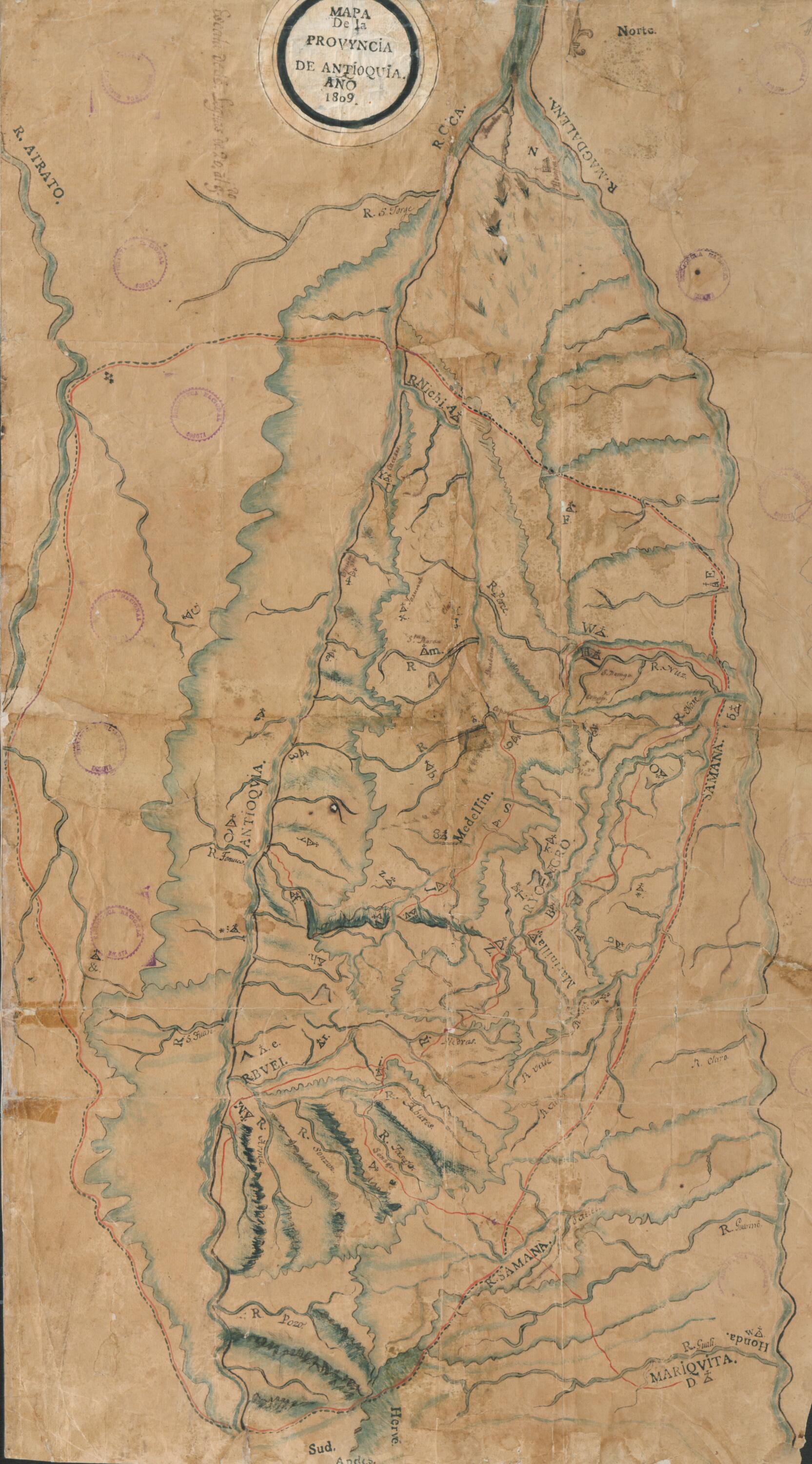
Map of the Province of Antioquia. (Mapa De La Provincia De Antioquia) 1809
- Regular price
-
$57.95 - Regular price
-
$52.95 - Sale price
-
$57.95
Buy one map, get any other map in our collection for 50% OFF! Add to cart to see discount.
Couldn't load pickup availability
About This Map
Discover the timeless beauty of our fine art quality printed reproduction of this antique map. Perfect for history enthusiasts, collectors, and interior decorators.
Restored with meticulous attention to detail by our team with over a decade of experience, this stunning reproduction captures the intricate artistry and historical significance of the original map.
Whether you're a collector or seeking a unique decor piece, this archival-quality map reproduction is a timeless addition to any space. Order now to bring history to life!
Old map of Antioquia, Colombia.-1863) first became known as the geographer and cartographer of the province of Antioquia in New Granada (the Spanish viceroyalty that comprised all or parts of present-day Colombia, Ecuador, Panama, and Venezuela). In 1807, Restrepo carried out geodesic and barometric measurements in 102 towns of the province. In 1809, he completed this map of Antioquia, the first attempt to depict with precision the province's rugged terrain. In the same year, he wrote an essay on the physical, social, and economic geography of the province that was published in the weekly Semanario del Nuevo Reino de Granada. Restrepo was a law student who, shortly before the events of 1810 that initiated Colombia's independence struggle, had become friendly with the scientist (and later revolutionary) Francisco José de Caldas. Caldas trained Restrepo in astronomy, geography and cartography and helped him correct his map of Antioquia. The map could not be published at the time because the printing presses in the colonial capital lacked the technology for printing maps or illustrations, but it circulated among well-informed citizens of New Granada. Restrepo's work as a geographer and cartographer helped him to attain a position in the imperial bureaucracy. The establishment of the 1810 junta catapulted him to greater power in Antioquia, and later in life he held many ministerial and other institutional positions. Besides his early work as an advocate and geographer, Restrepo is best remembered as a historian of the first Colombian republic.
Created by Francisco José De Caldas, José Manuel Restrepo in 1809.
- Title devised, in English, by Library staff.
- Original resource extent: 1 map : color ; 75 x 44 centimeters.
- Original resource at: National Library of Colombia.
- Content in Spanish.
- Description based on data extracted from World Digital Library, which may be extracted from partner institutions.
- For the best legibility, order your map in the original size or larger. Most maps have intricate detail and small text that is best appreciated when the print size hasn't been reduced.
- Sizes labeled "Fits a Standard Frame" will drop right into any frame that you purchase in that size. The sizes that we offer are commonly available online and at most retail stores.
- Our standard sizes are recommendations based on the aspect ratio of the original map, but still may require some added "white space" in one dimension to fit.
- Non-standard sizes will require custom framing, and we suggest taking your print to the frame shop of your choice after you receive it for the best results.
- Custom sizes are available, simply contact us for a quote.
Below is an approximation of the scale of a few standard sizes, and how they might appear in your space.

