
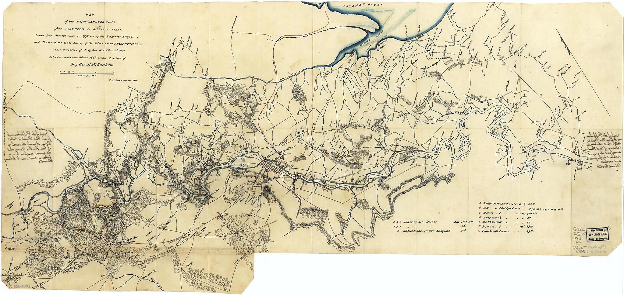
Map of the Rappahannock River Fron sic Port Royal to Richards Ferry (Map of the Rappahannock River from Port Royal to Richards Ferry) 1863
- Regular price
-
$66.95 - Regular price
-
$61.95 - Sale price
-
$66.95
Buy one map, get any other map in our collection for 50% OFF! Add to cart to see discount.
Couldn't load pickup availability
About This Map
Discover the timeless beauty of our fine art quality printed reproduction of this antique map. Perfect for history enthusiasts, collectors, and interior decorators.
Restored with meticulous attention to detail by our team with over a decade of experience, this stunning reproduction captures the intricate artistry and historical significance of the original map.
Whether you're a collector or seeking a unique decor piece, this archival-quality map reproduction is a timeless addition to any space. Order now to bring history to life!
Old map of Fredericksburg Region, Rappahannock River, Rappahannock River Valley, United States, Virginia.Created by Henry Washington Benham, United States Coast Survey, United States. Army of the Potomac. Engineer Brigade, John S. Vernam, Daniel P. (Daniel Phineas) Woodbury in 1863.
- Relief shown by hachures.
- Also covers Fredericksburg city region.
- Shows "Lines of Gen. Hooker" at Chancellorsville, "Battle field of Gen. Sedgwick" at Salem Church, military bridges, towns, farmsteads with residents' names, wooded areas, and streams.
- Pen-and-ink (black/red) and watercolor (blue).
- Endorsed in ink handwriting on verso on 2 panels: Map of the Rappahannock from Port Royal to Kelly's Ford, showing the crossings of Gen. Hookers army and the ground occupied by our forces in and around Chancellorville [sic].
- Oriented with north toward the upper left.
- A printed version of this map appears as plate 39, map 2, in the U.S. War Dept.'s: Atlas to accompany the official records of the Union and Confederate armies (Washington, G.P.O., 1891-95).
- The area south of Chancellorsville is on a separate linen sheet spliced to the bottom of the main sheet.
- Includes index of military bridge construction sites.
- Civil War Map
Map Subjects
Civil War
Fredericksburg Region
Fredericksburg Region (Va.)
History
Maps Manuscript
Military Bridges
Rappahannock River
Rappahannock River Valley
Rappahannock River Valley (Va.)
United States
Virginia
Henry Washington Benham
United States Coast Survey
United States. Army Of The Potomac. Engineer Brigade
John S. Vernam
Daniel P. (Daniel Phineas) Woodbury
1863
- For the best legibility, order your map in the original size or larger. Most maps have intricate detail and small text that is best appreciated when the print size hasn't been reduced.
- Sizes labeled "Fits a Standard Frame" will drop right into any frame that you purchase in that size. The sizes that we offer are commonly available online and at most retail stores.
- Our standard sizes are recommendations based on the aspect ratio of the original map, but still may require some added "white space" in one dimension to fit.
- Non-standard sizes will require custom framing, and we suggest taking your print to the frame shop of your choice after you receive it for the best results.
- Custom sizes are available, simply contact us for a quote.
Below is an approximation of the scale of a few standard sizes, and how they might appear in your space.
