
Map of the Republic of Colombia 1891
- Regular price
-
$54.95 - Regular price
-
$30.95 - Sale price
-
$54.95
Buy one map, get any other map in our collection for 50% OFF! Add to cart to see discount.
Couldn't load pickup availability
About This Map
Discover the timeless beauty of our fine art quality printed reproduction of this antique map. Perfect for history enthusiasts, collectors, and interior decorators.
Restored with meticulous attention to detail by our team with over a decade of experience, this stunning reproduction captures the intricate artistry and historical significance of the original map.
Whether you're a collector or seeking a unique decor piece, this archival-quality map reproduction is a timeless addition to any space. Order now to bring history to life!
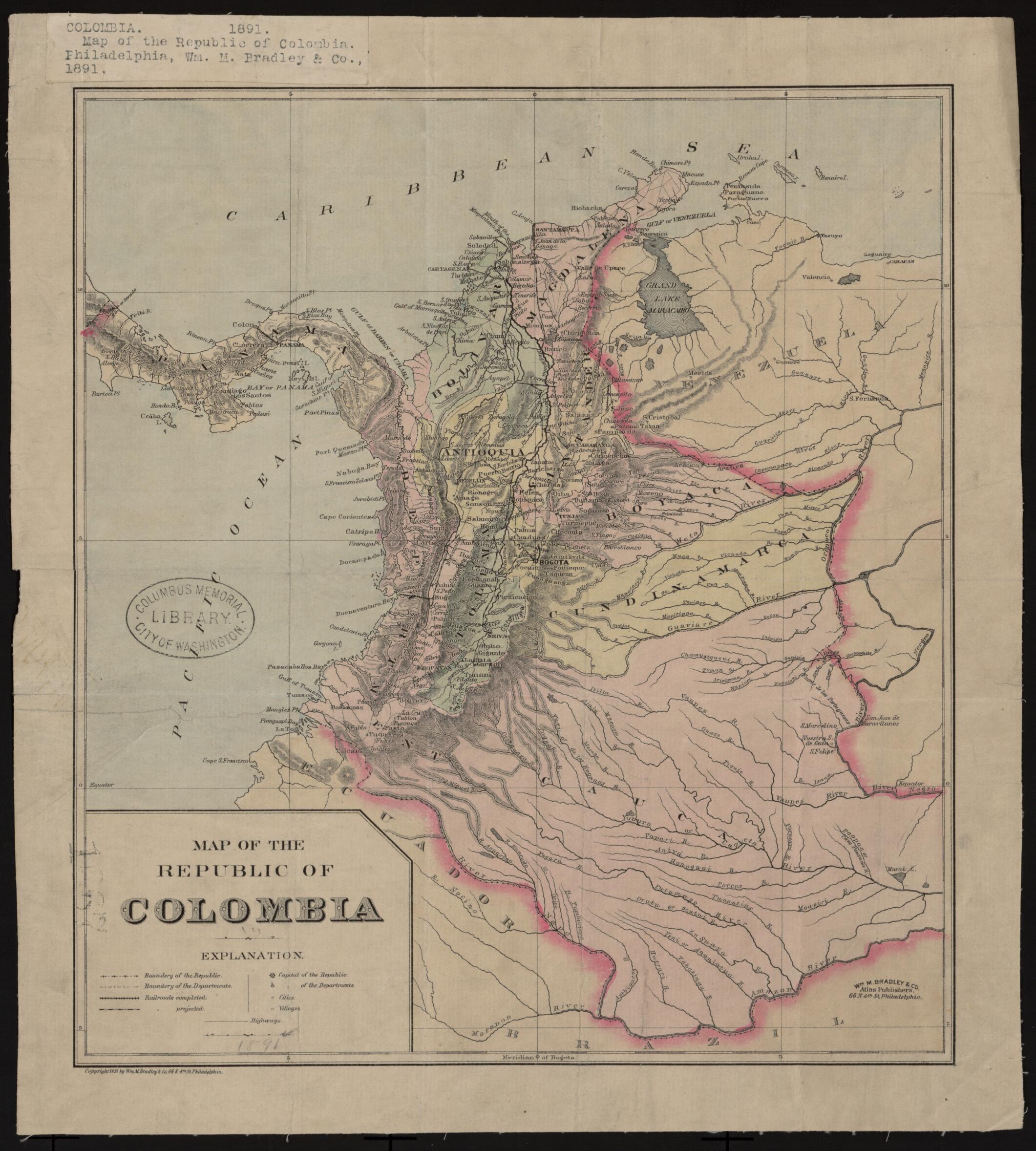
Old map of Colombia, Panama.day Panama, which did not become independent until 1903, is still shown as a department of Colombia. The railroad across the Isthmus of Panama, from Colón to Panama City, is indicated, but the Panama Canal has not yet been built. The eastern part of the country is shown as thinly settled and not well mapped, but the many tributaries flowing southeastward into the Amazon are clearly visible. Parts of the neighboring countries of Venezuela, Brazil, Ecuador, and Peru are shown. An unusual feature of the map is the setting of the prime meridian at the capital city of Bogota (approximately 74°W), rather than at Greenwich, United Kingdom, which was standard practice among mapmakers at that time. The map was issued by William M. Bradley & Company, a prominent late-19th century publisher of maps and atlases based in Philadelphia.
- Title devised, in English, by Library staff.
- "Scale around 1 inch to 6,336,000 feet"--Note extracted from World Digital Library.
- Original resource extent: 1 map : mounted on linen, color ; 29 x 26 centimeters.
- Original resource at: Columbus Memorial Library, Organization of American States.
- Content in English.
- Description based on data extracted from World Digital Library, which may be extracted from partner institutions.
- For the best legibility, order your map in the original size or larger. Most maps have intricate detail and small text that is best appreciated when the print size hasn't been reduced.
- Sizes labeled "Fits a Standard Frame" will drop right into any frame that you purchase in that size. The sizes that we offer are commonly available online and at most retail stores.
- Our standard sizes are recommendations based on the aspect ratio of the original map, but still may require some added "white space" in one dimension to fit.
- Non-standard sizes will require custom framing, and we suggest taking your print to the frame shop of your choice after you receive it for the best results.
- Custom sizes are available, simply contact us for a quote.
Below is an approximation of the scale of a few standard sizes, and how they might appear in your space.

