
Map of the Republic of Costa Rica 1891
- Regular price
-
$49.95 - Regular price
-
$34.95 - Sale price
-
$49.95
Buy one map, get any other map in our collection for 50% OFF! Add to cart to see discount.
Couldn't load pickup availability
About This Map
Discover the timeless beauty of our fine art quality printed reproduction of this antique map. Perfect for history enthusiasts, collectors, and interior decorators.
Restored with meticulous attention to detail by our team with over a decade of experience, this stunning reproduction captures the intricate artistry and historical significance of the original map.
Whether you're a collector or seeking a unique decor piece, this archival-quality map reproduction is a timeless addition to any space. Order now to bring history to life!
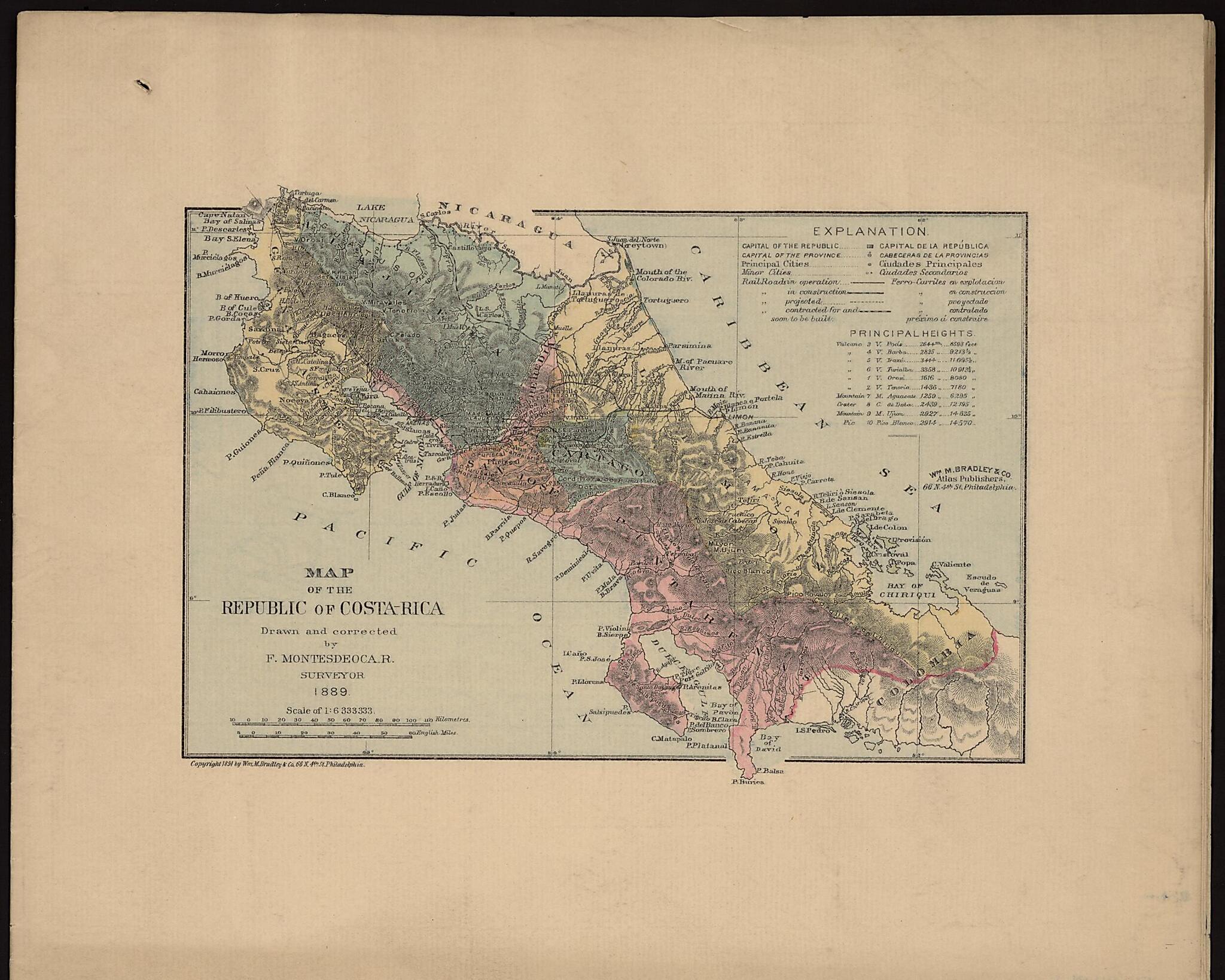
Old map of Costa Rica.right-hand corner, is in Spanish and English. Indicated on the map are the national capital, San José; provincial capitals; principal cities; minor cities; and railroads (in operation, under construction, projected, and "contracted for and soon to be built"). The highest mountains, volcanoes, and craters are indicated by the numbered key, and their heights given (inaccurately) in both feet and meters. The country's seven provinces--Alajuela, Cartago, Guanacaste, Heredia, Limón, Puntarenas, and San José--are shown and distinguished by different colors. Costa Rica is shown as bordering directly on Colombia to the south, as the Republic of Panama was not established until 1903. The northern border, with Nicaragua, is formed by Lake Nicaragua and the San Juan River. The map was drawn by surveyor Faustino Montes de Oca Ramirez (1862--1902) and issued by William M. Bradley & Company, a prominent late-19th century publisher of maps and atlases based in Philadelphia.
Created by Faustino Montes De Oca Ramirez in 1891.
- Title devised, in English, by Library staff.
- "Scale 1 inch to 2,535,000 feet"--Note extracted from World Digital Library.
- Original resource extent: 2 maps : color ; 13 x 20 centimeters.
- Original resource at: Columbus Memorial Library, Organization of American States.
- Content in English and Spanish.
- Description based on data extracted from World Digital Library, which may be extracted from partner institutions.
Map Subjects
Costa Rica
Faustino Montes De Oca Ramirez
1891
- For the best legibility, order your map in the original size or larger. Most maps have intricate detail and small text that is best appreciated when the print size hasn't been reduced.
- Sizes labeled "Fits a Standard Frame" will drop right into any frame that you purchase in that size. The sizes that we offer are commonly available online and at most retail stores.
- Our standard sizes are recommendations based on the aspect ratio of the original map, but still may require some added "white space" in one dimension to fit.
- Non-standard sizes will require custom framing, and we suggest taking your print to the frame shop of your choice after you receive it for the best results.
- Custom sizes are available, simply contact us for a quote.
Below is an approximation of the scale of a few standard sizes, and how they might appear in your space.

