
Map of the Sea 1572
- Regular price
-
$80.95 - Regular price
-
$75.95 - Sale price
-
$80.95
Buy one map, get any other map in our collection for 50% OFF! Add to cart to see discount.
Couldn't load pickup availability
About This Map
Discover the timeless beauty of our fine art quality printed reproduction of this antique map. Perfect for history enthusiasts, collectors, and interior decorators.
Restored with meticulous attention to detail by our team with over a decade of experience, this stunning reproduction captures the intricate artistry and historical significance of the original map.
Whether you're a collector or seeking a unique decor piece, this archival-quality map reproduction is a timeless addition to any space. Order now to bring history to life!
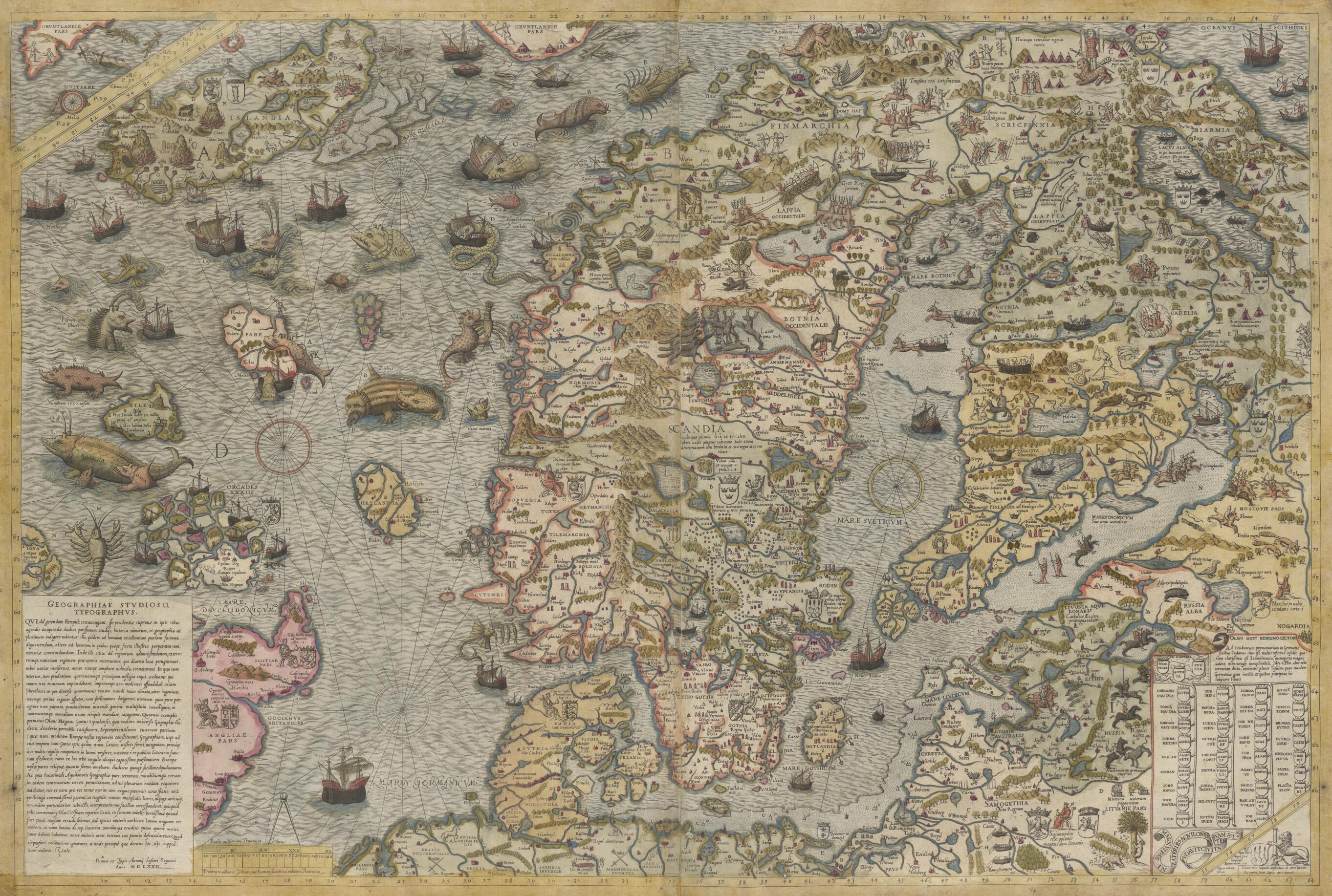
Old map of Finland, Norway, Sweden.The Carta marina of the Swedish geographer and historian Olaus Magnus is one of the earliest accurate cartographic depictions of the Scandinavian peninsula. Drafted in Rome in 1539, by one of the more prominent Scandinavian Catholics in higher ecclesiastical service, it contains detail that is lacking in many other early maps of the region. Originally intended for his Historia de gentibus septentrionalibus (A description of the Nordic peoples), the map was published some 15 years before the appearance of this majestic work. Olaus Magnus is generally regarded as the first to propound the idea of a Northeast Passage. This is the second edition of this map, published by Antoine Lafréry in 1572.
Created by Olaus Magnus in 1572.
- Title devised, in English, by Library staff.
- "Scale 1:3,700,000"--Note extracted from World Digital Library.
- Original resource extent: 1 map on 2 sheets joined together: copper engraving, color, 52 x 79 centimeters.
- Original resource at: National Library of Sweden.
- Content in Latin.
- Description based on data extracted from World Digital Library, which may be extracted from partner institutions.
- For the best legibility, order your map in the original size or larger. Most maps have intricate detail and small text that is best appreciated when the print size hasn't been reduced.
- Sizes labeled "Fits a Standard Frame" will drop right into any frame that you purchase in that size. The sizes that we offer are commonly available online and at most retail stores.
- Our standard sizes are recommendations based on the aspect ratio of the original map, but still may require some added "white space" in one dimension to fit.
- Non-standard sizes will require custom framing, and we suggest taking your print to the frame shop of your choice after you receive it for the best results.
- Custom sizes are available, simply contact us for a quote.
Below is an approximation of the scale of a few standard sizes, and how they might appear in your space.
