
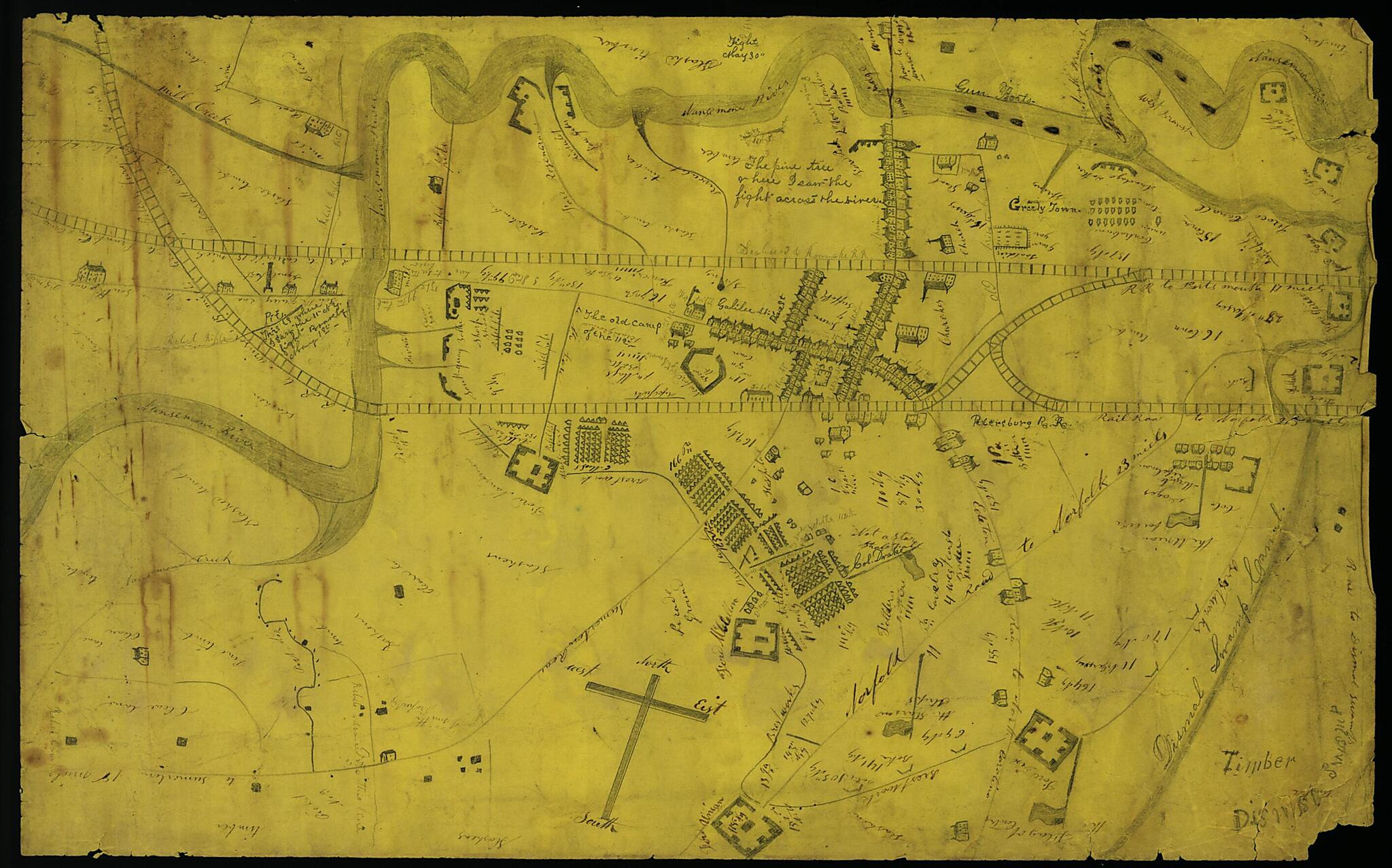
Map of the Siege of Suffolk, Va., 1863.
- Regular price
-
$49.95 - Regular price
-
$34.95 - Sale price
-
$49.95
Buy one map, get any other map in our collection for 50% OFF! Add to cart to see discount.
Couldn't load pickup availability
About This Map
Discover the timeless beauty of our fine art quality printed reproduction of this antique map. Perfect for history enthusiasts, collectors, and interior decorators.
Restored with meticulous attention to detail by our team with over a decade of experience, this stunning reproduction captures the intricate artistry and historical significance of the original map.
Whether you're a collector or seeking a unique decor piece, this archival-quality map reproduction is a timeless addition to any space. Order now to bring history to life!
Old map of Suffolk, United States, Virginia.4 May 1863, and indicates the location of Federal troops, railroads, roads, parade ground, breastworks, hospital, and forts, and the placement Federal gunboats in the Nansemond River.
Created by Orrin Sweet Allen in 1863.
- Orrin Sweet Allen papers, 1862-1865 (Mss2 AL543 a 1), Virginia Historical Society.
- Orrin Sweet Allen was a carpenter from Harmony, N.Y., who served in Company H of the 112th New York Volunteer Infantry of the U.S. Army.
- Gift of Roscoe N. and Betty A. Allen through the courtesy of Nelson F. Allen and Tracy L. Allen, Spring, Tex., 15 March 2002.
- Manuscripts
Map Subjects
Campaigns
Civil War
History
Siege
Siege Warfare
Suffolk
Suffolk (Va.)
United States
Virginia
Orrin Sweet Allen
1863
- For the best legibility, order your map in the original size or larger. Most maps have intricate detail and small text that is best appreciated when the print size hasn't been reduced.
- Sizes labeled "Fits a Standard Frame" will drop right into any frame that you purchase in that size. The sizes that we offer are commonly available online and at most retail stores.
- Our standard sizes are recommendations based on the aspect ratio of the original map, but still may require some added "white space" in one dimension to fit.
- Non-standard sizes will require custom framing, and we suggest taking your print to the frame shop of your choice after you receive it for the best results.
- Custom sizes are available, simply contact us for a quote.
Below is an approximation of the scale of a few standard sizes, and how they might appear in your space.
