

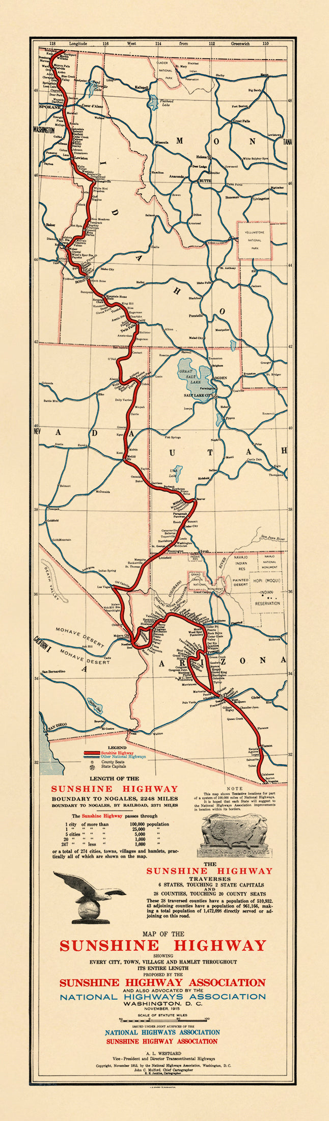
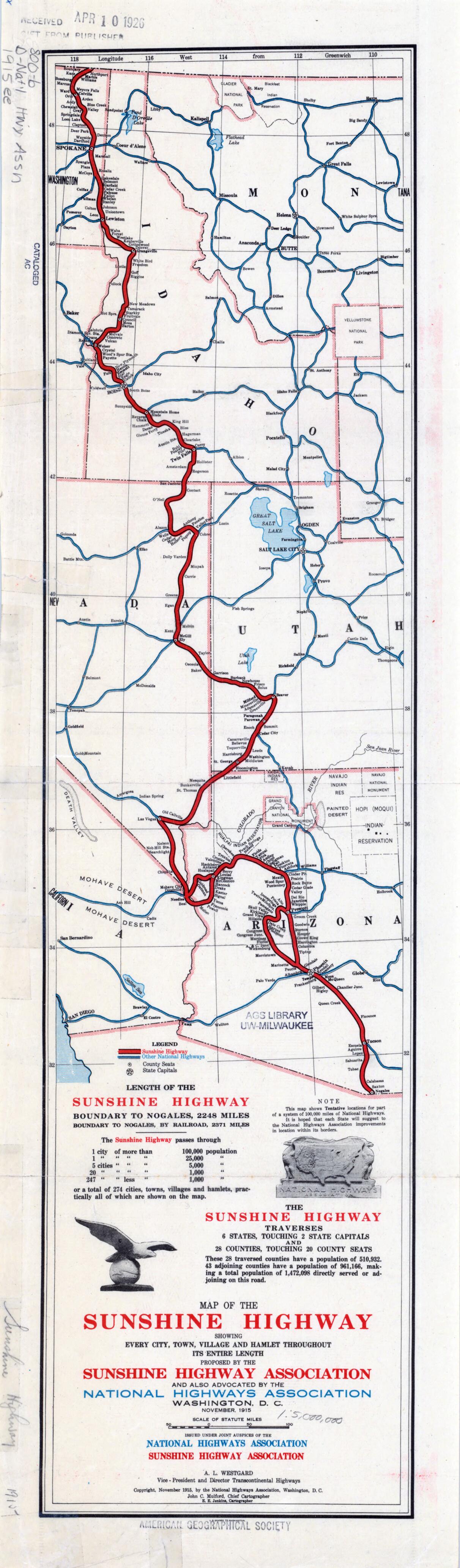
Map of the Sunshine Highway. (Map of the Sunshine Highway: Showing Every City, Town, Village and Hamlet Throughout Its Entire Length) 1915
- Regular price
-
$49.95 - Regular price
-
$34.95 - Sale price
-
$49.95
Buy one map, get any other map in our collection for 50% OFF! Add to cart to see discount.
Couldn't load pickup availability
About This Map
Discover the timeless beauty of our fine art quality printed reproduction of this antique map. Perfect for history enthusiasts, collectors, and interior decorators.
Restored with meticulous attention to detail by our team with over a decade of experience, this stunning reproduction captures the intricate artistry and historical significance of the original map.
Whether you're a collector or seeking a unique decor piece, this archival-quality map reproduction is a timeless addition to any space. Order now to bring history to life!
Old map of Arizona, California, Idaho, Nevada, United States of America, Utah, Washington.-Canada border in Washington State to Nogales, Arizona, on the U.S.--Mexico border, a distance of 2,248 miles (3,618 kilometers). The notes and table in the lower left indicate the numbers of states, counties, and cities of different sizes traversed by the route and the population expected to be served. Besides issuing brochures and circulars aimed at convincing citizens of the need for a national road system, the NHA was a prolific producer of maps. Cartographic work was done at an office in South Yarmouth, Massachusetts, where approximately 40 people were employed on the property of Charles Henry Davis (1865--1951), president and cofounder of the NHA. Davis believed that these maps would be helpful to a national highways commission that he hoped would be established and that they would assist the states in integrating their roads into a national system. Congress never embraced the plan put forward by the NHA, but the organization and its maps helped to promote the cause of a national road network.
Created by E. E. Jenkins, John C. Mulford, National Highways Association, Sunshine Highway Association in 1915.
- Title devised, in English, by Library staff.
- "Scale 1:5,000,000"--Note extracted from World Digital Library.
- Original resource extent: 1 map : color ; 56 x 14 centimeters.
- Original resource at: University of Wisconsin-Milwaukee Libraries.
- Content in English.
- Description based on data extracted from World Digital Library, which may be extracted from partner institutions.
- For the best legibility, order your map in the original size or larger. Most maps have intricate detail and small text that is best appreciated when the print size hasn't been reduced.
- Sizes labeled "Fits a Standard Frame" will drop right into any frame that you purchase in that size. The sizes that we offer are commonly available online and at most retail stores.
- Our standard sizes are recommendations based on the aspect ratio of the original map, but still may require some added "white space" in one dimension to fit.
- Non-standard sizes will require custom framing, and we suggest taking your print to the frame shop of your choice after you receive it for the best results.
- Custom sizes are available, simply contact us for a quote.
Below is an approximation of the scale of a few standard sizes, and how they might appear in your space.

