
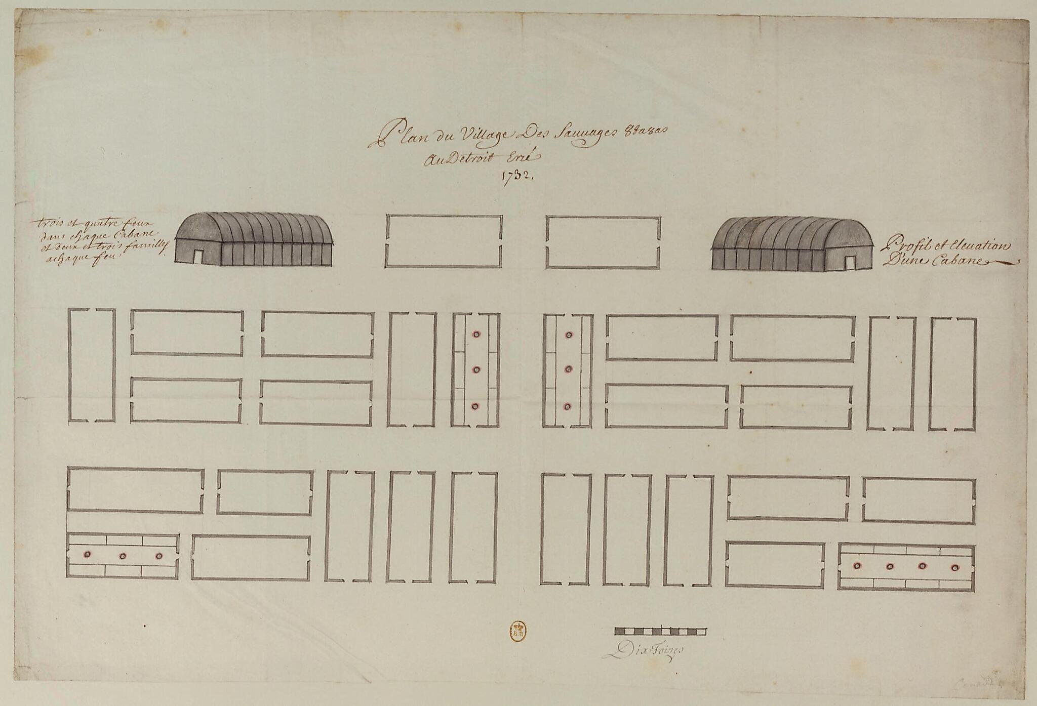
Map of the Village of the Ottawa Savages, at the Erie Strait, 1732. (Plan Du Village Des Sauvages Outaouas, Au Détroit Erié, 1732)
- Regular price
-
$49.95 - Regular price
-
$34.95 - Sale price
-
$49.95
Buy one map, get any other map in our collection for 50% OFF! Add to cart to see discount.
Couldn't load pickup availability
About This Map
Discover the timeless beauty of our fine art quality printed reproduction of this antique map. Perfect for history enthusiasts, collectors, and interior decorators.
Restored with meticulous attention to detail by our team with over a decade of experience, this stunning reproduction captures the intricate artistry and historical significance of the original map.
Whether you're a collector or seeking a unique decor piece, this archival-quality map reproduction is a timeless addition to any space. Order now to bring history to life!
Old map of Detroit, Michigan, United States of America.like pattern in which communal houses known as wigwams were arranged. At the top of the map two houses are drawn in profile, and a note reads: "three and four fires in each hut and two and three families at each fire." Scale on the map is given in toises, an old French unit of measurement; one toise equals about 1.95 meters. When the Europeans first arrived in North America, the Ottawa (from a native word meaning to "trade," also seen as Odawa) lived along the Ottawa River in eastern Ontario and western Quebec. Samuel de Champlain recorded meeting them already in 1615. They later moved into parts of what are today Ohio and Michigan. The Ottawa played an important role in the fur trade with the French. They were generally allied with the Hurons and enemies of the Iroquois. In choosing the word "des sauvages" to denote the people of North America, Champlain did not mean "savages," but "forest dwellers" (from the Latin silva).
- Title devised, in English, by Library staff.
- Original resource extent: 1 drawing : pen, ink wash and watercolor ; 34.5 x 52 centimeters.
- Original resource at: National Library of France.
- Content in French.
- Description based on data extracted from World Digital Library, which may be extracted from partner institutions.
Map Subjects
Architecture Domestic
Detroit
France In America
Great Lakes Region (North America)
Indian Architecture
Indians Of North America
Manuscript Maps
Michigan
New France
Ottawa Indians
United States Of America
Villages
1732
- For the best legibility, order your map in the original size or larger. Most maps have intricate detail and small text that is best appreciated when the print size hasn't been reduced.
- Sizes labeled "Fits a Standard Frame" will drop right into any frame that you purchase in that size. The sizes that we offer are commonly available online and at most retail stores.
- Our standard sizes are recommendations based on the aspect ratio of the original map, but still may require some added "white space" in one dimension to fit.
- Non-standard sizes will require custom framing, and we suggest taking your print to the frame shop of your choice after you receive it for the best results.
- Custom sizes are available, simply contact us for a quote.
Below is an approximation of the scale of a few standard sizes, and how they might appear in your space.
