
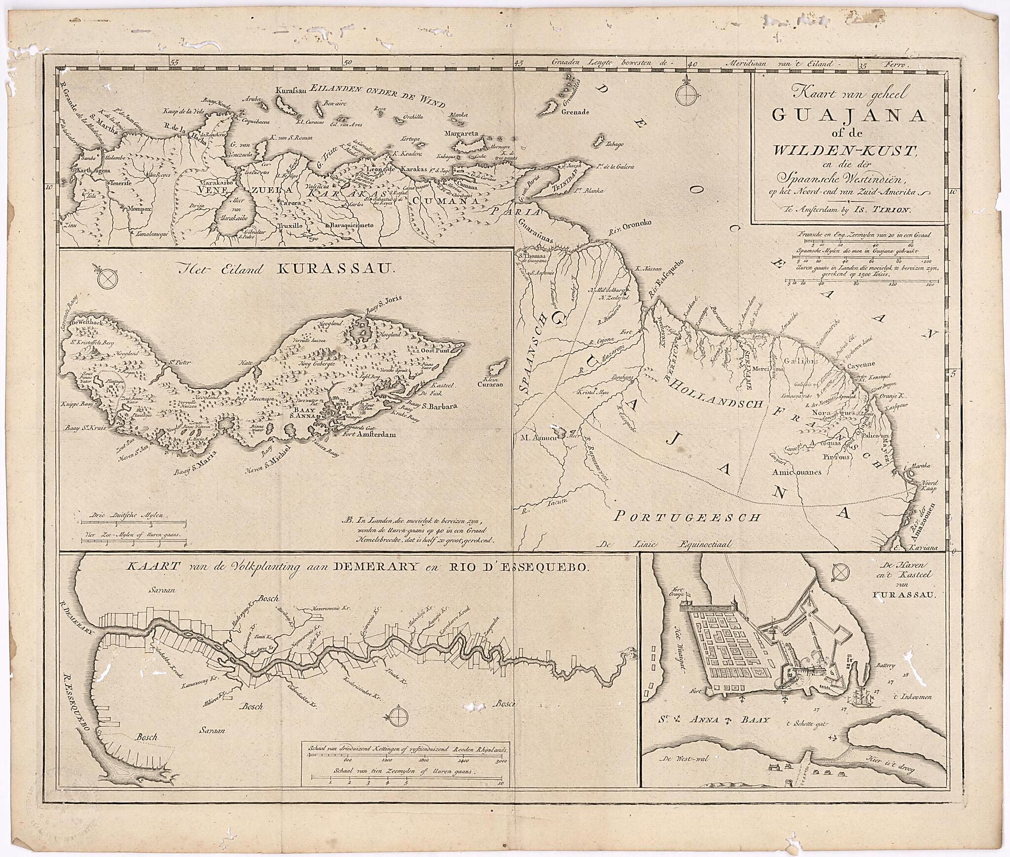
Map of the Whole of Guiana Or the Savage Coast, and the Spanish West Indies at the Northern End of South America. (Kust) 1720
- Regular price
-
$54.95 - Regular price
-
$49.95 - Sale price
-
$54.95
Buy one map, get any other map in our collection for 50% OFF! Add to cart to see discount.
Couldn't load pickup availability
About This Map
Discover the timeless beauty of our fine art quality printed reproduction of this antique map. Perfect for history enthusiasts, collectors, and interior decorators.
Restored with meticulous attention to detail by our team with over a decade of experience, this stunning reproduction captures the intricate artistry and historical significance of the original map.
Whether you're a collector or seeking a unique decor piece, this archival-quality map reproduction is a timeless addition to any space. Order now to bring history to life!
Old map of Brazil, Colombia, France, French Guiana, Grenada, Guyana, Suriname, Trinidad and Tobago, Venezuela (Bolivarian Republic of).century Dutch map, produced in Amsterdam by the publisher Isaak Tirion (circa 1705--circa 1769), shows the northern coast of South American and its offshore islands, including Curaçao, Bonaire, and neighboring islands; Trinidad and Tobago; and Grenada. Guiana is divided, from west to east, into Spanish, Dutch, and French sections, corresponding roughly to a part of present-day Venezuela and present-day Guyana, Suriname, and French Guiana. The territory to the south of Guiana, in present-day Brazil, is labeled as Portuguese. Three scales are given in the main map: French and English nautical miles; Spanish miles; and number of hours needed to cover certain distances. The inset maps provide detailed views of the island of Curaçao, the Dutch plantations along the Essequibo and Demerara Rivers, and the harbor and castle of Curaçao. In 1814 the Dutch ceded control of their colonies in Essequibo and Demerara to the British, who consolidated them into the colony of British Guiana, which became the independent state of Guyana in 1966.
Created by Isaak Tirion in 1720.
- Title devised, in English, by Library staff.
- Original resource at: Columbus Memorial Library, Organization of American States.
- Content in Dutch.
- Description based on data extracted from World Digital Library, which may be extracted from partner institutions.
Map Subjects
1720 To 1769
Brazil
Colombia
Colonies
France
French Guiana
Great Britain
Grenada
Guyana
Netherlands
Portugal
Suriname
Trinidad And Tobago
Venezuela (Bolivarian Republic Of)
West Indies
Isaak Tirion
1720
- For the best legibility, order your map in the original size or larger. Most maps have intricate detail and small text that is best appreciated when the print size hasn't been reduced.
- Sizes labeled "Fits a Standard Frame" will drop right into any frame that you purchase in that size. The sizes that we offer are commonly available online and at most retail stores.
- Our standard sizes are recommendations based on the aspect ratio of the original map, but still may require some added "white space" in one dimension to fit.
- Non-standard sizes will require custom framing, and we suggest taking your print to the frame shop of your choice after you receive it for the best results.
- Custom sizes are available, simply contact us for a quote.
Below is an approximation of the scale of a few standard sizes, and how they might appear in your space.

