
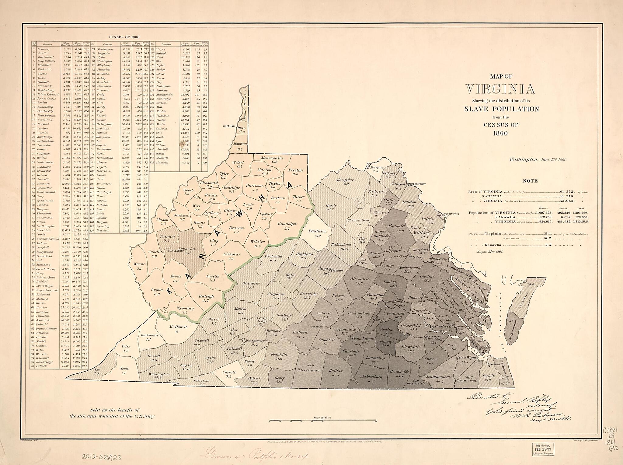
Map of Virginia : Showing the Distribution of Its Slave Population from the Census of 1860 1861
- Regular price
-
$110.95 - Regular price
-
$105.95 - Sale price
-
$110.95
Buy one map, get any other map in our collection for 50% OFF! Add to cart to see discount.
Couldn't load pickup availability
About This Map
Discover the timeless beauty of our fine art quality printed reproduction of this antique map. Perfect for history enthusiasts, collectors, and interior decorators.
Restored with meticulous attention to detail by our team with over a decade of experience, this stunning reproduction captures the intricate artistry and historical significance of the original map.
Whether you're a collector or seeking a unique decor piece, this archival-quality map reproduction is a timeless addition to any space. Order now to bring history to life!
Old map of United States, Virginia.Created by H. S. (Henry S.) Graham, E. (Edwin) Hergesheimer, Theo. (Theodore) Leonhardt in 1861.
- West Virginia shown as Kanawha.
- "Washington, June 13th, 1861."
- "Entered according to Act of Congress, A.D. 1861 by Henry S. Graham, in the Clerk's Office of the District of Columbia."
- "Sold for the benefit of the sick and wounded of the U.S. Army."
- Includes population table based on census of 1860 by county dated "August 27th 1861" and note.
- Manuscript annotation in lower right corner: Presented to ... W.R. Palmer, Augt 30, 1861. Also annotated in red ink in lower margin: Drawer 47, portfolio 1 no. 24.
Map Subjects
19th Century
African Americans
History
Population
Slavery
United States
Virginia
H. S. (Henry S.) Graham
E. (Edwin) Hergesheimer
Theo. (Theodore) Leonhardt
1861
- For the best legibility, order your map in the original size or larger. Most maps have intricate detail and small text that is best appreciated when the print size hasn't been reduced.
- Sizes labeled "Fits a Standard Frame" will drop right into any frame that you purchase in that size. The sizes that we offer are commonly available online and at most retail stores.
- Our standard sizes are recommendations based on the aspect ratio of the original map, but still may require some added "white space" in one dimension to fit.
- Non-standard sizes will require custom framing, and we suggest taking your print to the frame shop of your choice after you receive it for the best results.
- Custom sizes are available, simply contact us for a quote.
Below is an approximation of the scale of a few standard sizes, and how they might appear in your space.

