
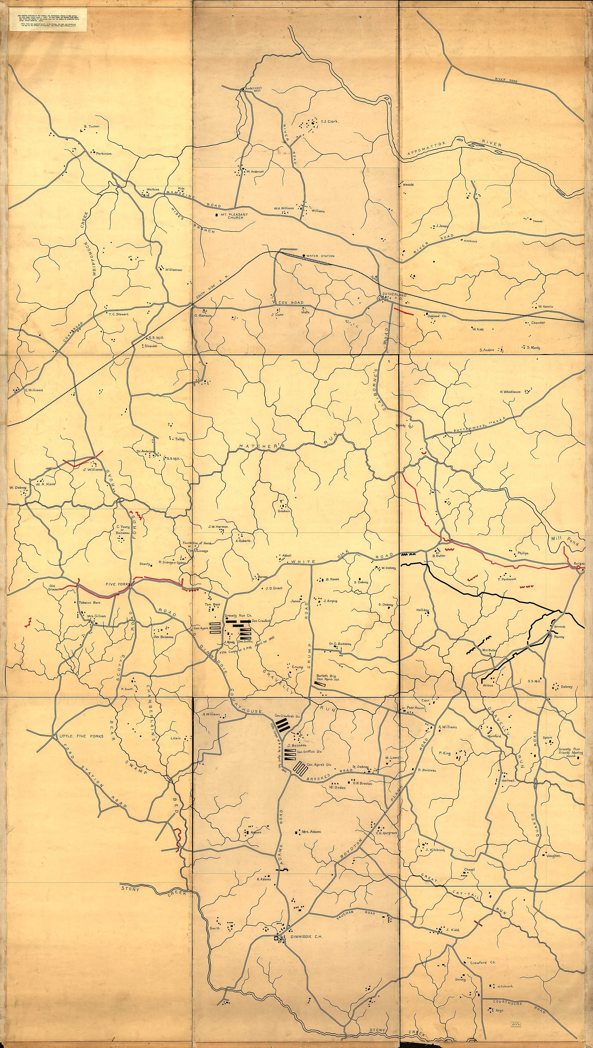
Map Showing Portions of the Federal and Confederate Forces at the Battle of Five Forks, Fought April 1, in 1865 : It Also Shows the Country Over Which Was Fought the Battle of Quaker Road and the Battle of Dinwiddie Court House, Fought March 31, in 1865
- Regular price
-
$305.95 - Regular price
-
$300.95 - Sale price
-
$305.95
Buy one map, get any other map in our collection for 50% OFF! Add to cart to see discount.
Couldn't load pickup availability
About This Map
Discover the timeless beauty of our fine art quality printed reproduction of this antique map. Perfect for history enthusiasts, collectors, and interior decorators.
Restored with meticulous attention to detail by our team with over a decade of experience, this stunning reproduction captures the intricate artistry and historical significance of the original map.
Whether you're a collector or seeking a unique decor piece, this archival-quality map reproduction is a timeless addition to any space. Order now to bring history to life!
Old map of Dinwiddie County, United States, Virginia.Created by Aurestus S. Perham in 1865.
- Wall map of part of Dinwiddie County (Va.) showing Civil War troop positions, roads, railroad, settlements, buildings, farms with occupants' names, and streams. Does not show troop positions or movements for battles of Quaker Road or Dinwiddie Court House.
- Title from typewritten label affixed at upper left corner.
- Gift; Mr. A.S. Perham; 1920.
- Pen-and-ink (black and red) and lead-pencil guidelines.
- Civil War Map
Map Subjects
Civil War
Dinwiddie County
Dinwiddie County (Va.)
Dinwiddie Court House Battle Of Dinwiddie VA
Five Forks Battle Of VA
History
Landowners
Maps Manuscript
United States
Virginia
Aurestus S. Perham
1865
- For the best legibility, order your map in the original size or larger. Most maps have intricate detail and small text that is best appreciated when the print size hasn't been reduced.
- Sizes labeled "Fits a Standard Frame" will drop right into any frame that you purchase in that size. The sizes that we offer are commonly available online and at most retail stores.
- Our standard sizes are recommendations based on the aspect ratio of the original map, but still may require some added "white space" in one dimension to fit.
- Non-standard sizes will require custom framing, and we suggest taking your print to the frame shop of your choice after you receive it for the best results.
- Custom sizes are available, simply contact us for a quote.
Below is an approximation of the scale of a few standard sizes, and how they might appear in your space.

