
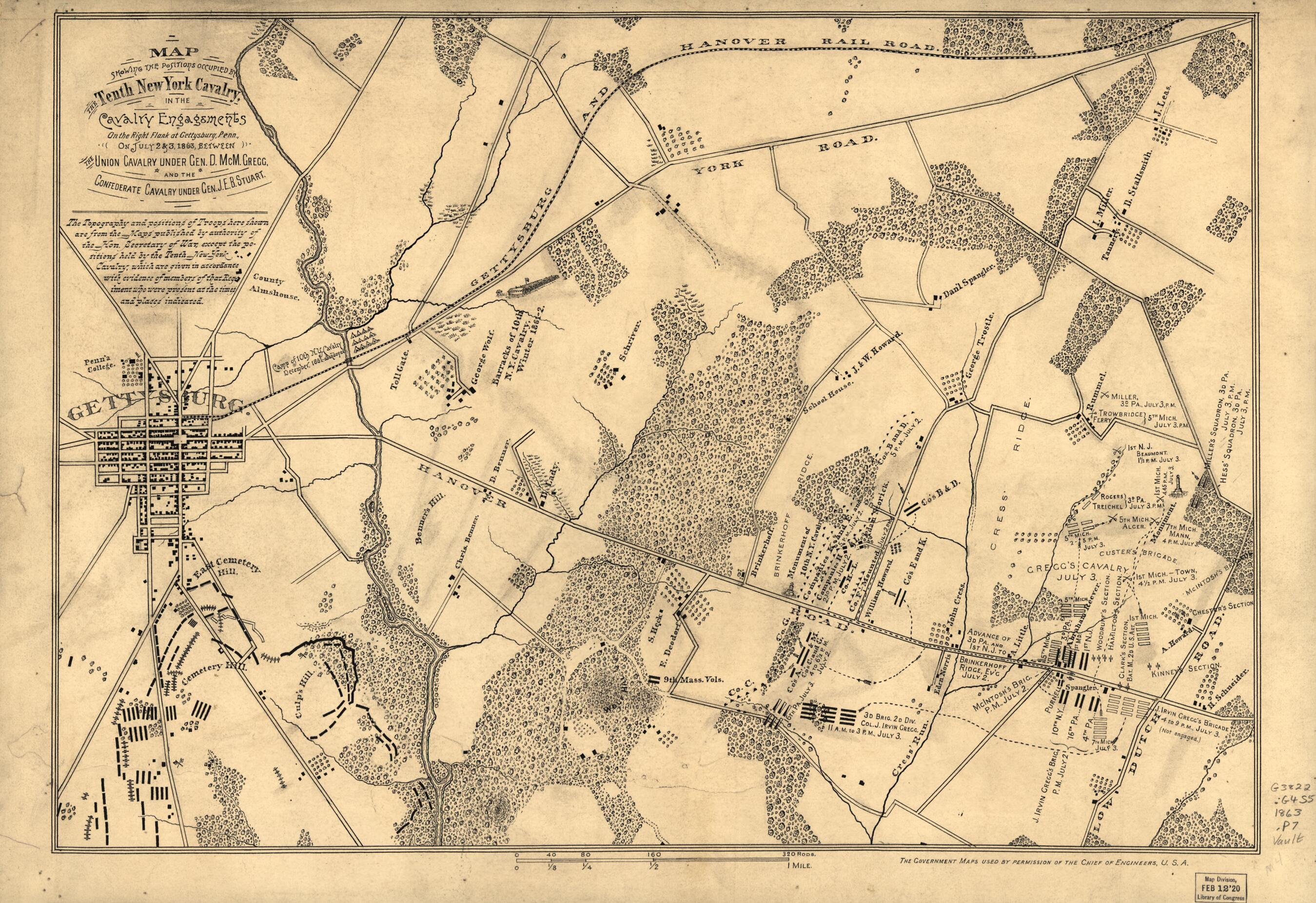
Map Showing the Positions Occupied by the Tenth New York Cavalry In the Cavalry Engagements On the Right Flank at Gettysburg, Pennsylvania : On July 2 & 3, in 1863, Between the Union Cavalry Under Gen. D. McM. Gregg and the Confederate Cavalry Under G...
- Regular price
-
$53.95 - Regular price
-
$48.95 - Sale price
-
$53.95
Buy one map, get any other map in our collection for 50% OFF! Add to cart to see discount.
Couldn't load pickup availability
About This Map
Discover the timeless beauty of our fine art quality printed reproduction of this antique map. Perfect for history enthusiasts, collectors, and interior decorators.
Restored with meticulous attention to detail by our team with over a decade of experience, this stunning reproduction captures the intricate artistry and historical significance of the original map.
Whether you're a collector or seeking a unique decor piece, this archival-quality map reproduction is a timeless addition to any space. Order now to bring history to life!
Old map of Gettysburg, Gettysburg Region, Pennsylvania, United States.Created by Noble D. Preston, United States. Army. Office of the Chief of Engineers in 1863.
- Finished ms. version of later printed map showing Federal cavalry positions and movements, camp and barracks of the 10th N.Y. Cavalry in 1861-62, drainage, vegetation, roads, streets, railroad, houses, and names of occupants.
- Covers troop positions in rural areas east of Gettysburg.
- Relief of hills shown by form lines.
- Printed version appears in Preston's History of the Tenth Regiment of Cavalry, New York State Volunteers, Aug. 1861 to Aug. 1865. New York, D. Appleton, 1892, opp. p. 116.
- In lower margin: The government maps used by permission of the Chief of Engineers, U.S.A.
- Pen-and-ink (india ink).
- Accompanied by 2 untitled ms. maps, presumably done as preliminary studies, on which the Union cavalry actions have been sketched partly in ink and partly in pencil. Also accompanied by 4 untitled ms. maps of the movements of "Stuart's cavalry, July 3, 2 to 5 P.M." apparently drawn as preliminary studies for the Confederate troop positions, which appear in red on the printed version. [6] maps : ms. ; 50 x 64 cm. or smaller, on sheets 55 x 73 cm.
- Includes text.
- Civil War Map
- For the best legibility, order your map in the original size or larger. Most maps have intricate detail and small text that is best appreciated when the print size hasn't been reduced.
- Sizes labeled "Fits a Standard Frame" will drop right into any frame that you purchase in that size. The sizes that we offer are commonly available online and at most retail stores.
- Our standard sizes are recommendations based on the aspect ratio of the original map, but still may require some added "white space" in one dimension to fit.
- Non-standard sizes will require custom framing, and we suggest taking your print to the frame shop of your choice after you receive it for the best results.
- Custom sizes are available, simply contact us for a quote.
Below is an approximation of the scale of a few standard sizes, and how they might appear in your space.
