
Map Showing Wet Areas On Passchendaele Front 1917
- Regular price
-
$53.95 - Regular price
-
$48.95 - Sale price
-
$53.95
Buy one map, get any other map in our collection for 50% OFF! Add to cart to see discount.
Couldn't load pickup availability
About This Map
Discover the timeless beauty of our fine art quality printed reproduction of this antique map. Perfect for history enthusiasts, collectors, and interior decorators.
Restored with meticulous attention to detail by our team with over a decade of experience, this stunning reproduction captures the intricate artistry and historical significance of the original map.
Whether you're a collector or seeking a unique decor piece, this archival-quality map reproduction is a timeless addition to any space. Order now to bring history to life!
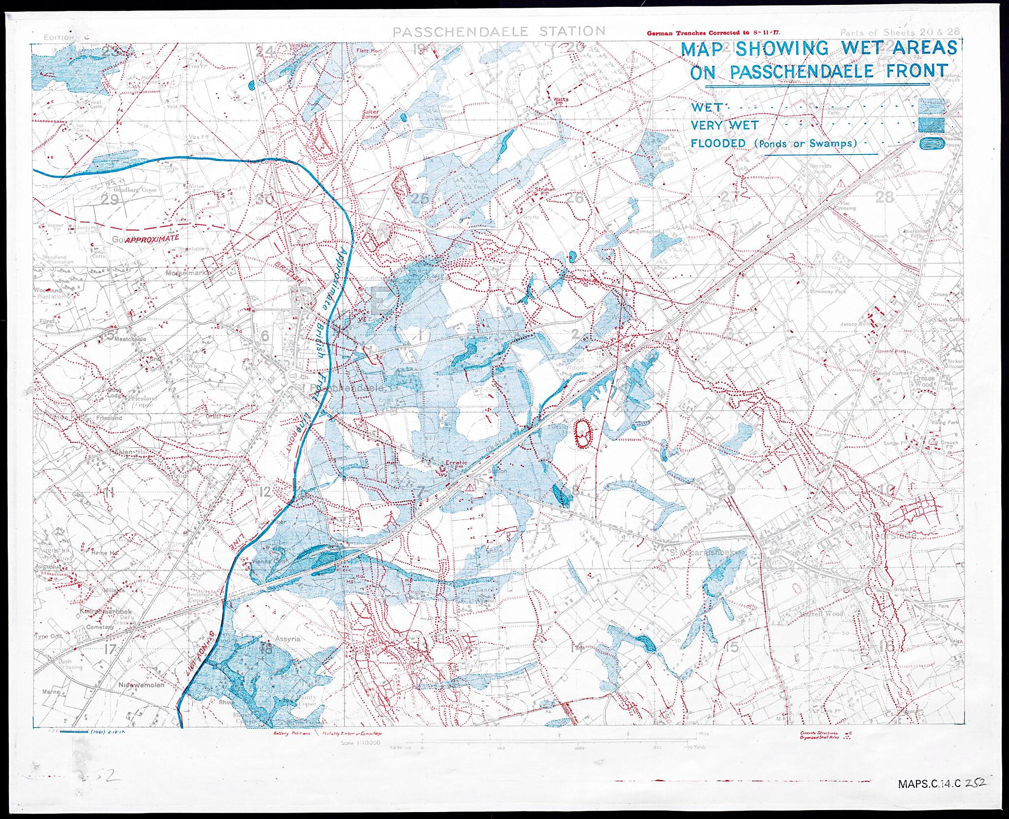
Old map of Belgium, Flanders, Passendale.2 in the areas to the north and east of Passchendaele village shown on the map. Apart from the German defenses (in red), the most notable features of the map are the blue-shaded areas. They mark the extensive wet and waterlogged areas facing the front. Exacerbated by poor weather and the devastation of the ground by the intense artillery bombardment, these conditions had hampered the Allied advance. The confused and fluid nature of the terrain was such that the strong blue line marking the front is only an approximation. No further British advances would take place at Passchendaele, and the gains made would be lost to German advances in the following spring.
- Title devised, in English, by Library staff.
- "Scale 1:10,000|Shelfmark: Maps C.14.c.252"--Note extracted from World Digital Library.
- Original resource extent: 1 map : color.
- Original resource at: The British Library.
- Content in English.
- Description based on data extracted from World Digital Library, which may be extracted from partner institutions.
Map Subjects
Battlefields
Belgium
Flanders
Germany. Army
Great Britain. Army
Manuscript Maps
Military Maps
Passendale
Trench Warfare
World War
1917
- For the best legibility, order your map in the original size or larger. Most maps have intricate detail and small text that is best appreciated when the print size hasn't been reduced.
- Sizes labeled "Fits a Standard Frame" will drop right into any frame that you purchase in that size. The sizes that we offer are commonly available online and at most retail stores.
- Our standard sizes are recommendations based on the aspect ratio of the original map, but still may require some added "white space" in one dimension to fit.
- Non-standard sizes will require custom framing, and we suggest taking your print to the frame shop of your choice after you receive it for the best results.
- Custom sizes are available, simply contact us for a quote.
Below is an approximation of the scale of a few standard sizes, and how they might appear in your space.

