
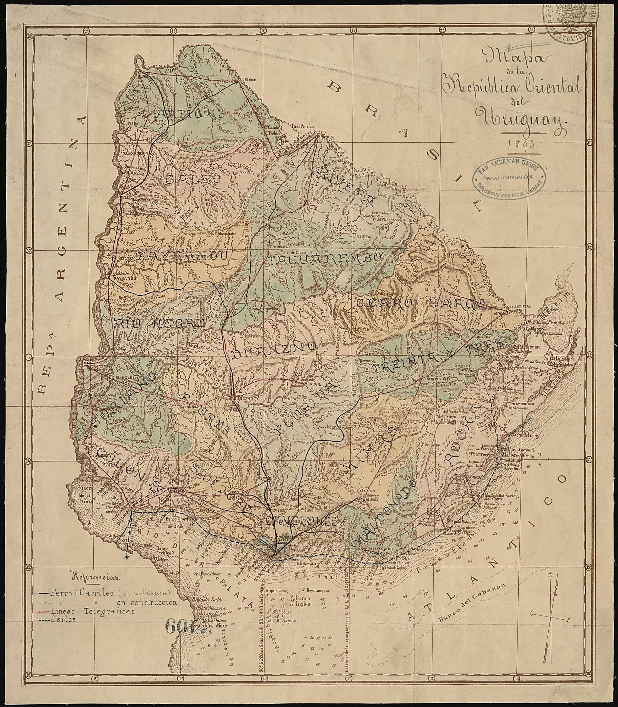
Map of the Eastern Republic of Uruguay, 1893. (Mapa De La República Oriental Del Uruguay, 1893)
- Regular price
-
$61.95 - Regular price
-
$43.95 - Sale price
-
$61.95
Buy one map, get any other map in our collection for 50% OFF! Add to cart to see discount.
Couldn't load pickup availability
About This Map
Discover the timeless beauty of our fine art quality printed reproduction of this antique map. Perfect for history enthusiasts, collectors, and interior decorators.
Restored with meticulous attention to detail by our team with over a decade of experience, this stunning reproduction captures the intricate artistry and historical significance of the original map.
Whether you're a collector or seeking a unique decor piece, this archival-quality map reproduction is a timeless addition to any space. Order now to bring history to life!
Old map of Uruguay.This 1893 map of the República Oriental del Uruguay (Eastern Republic of Uruguay), as the country is officially called, shows railroad lines (both in operation and under construction), telegraph lines, and submarine cables; and provinces and provincial boundaries. Relief is shown by hachures. The map provides navigational information relating to the Rio de la Plata, including water depths in meters and the location and visibility of lighthouses. Originally part of the Spanish Viceroyalty of the Rio de La Plata that also included Argentina, Paraguay, and parts of Bolivia, Brazil, and Chile, Uruguay achieved independence after a long struggle in the early 19th century that involved Spain, Portugal, Brazil, and Argentina. The Uruguayans originally broke from Spain in 1814, but the country was then occupied by Portuguese troops and annexed to the Portuguese colony of Brazil. With support from Argentina, Uruguayan patriots revolted against Brazil in 1825. In 1828 Brazil recognized the independence of Uruguay, largely under pressure from Great Britain, which objected to the Brazilian blockade of the ports of Montevideo and Buenos Aires. The map was produced in Montevideo and is now preserved in the Columbus Memorial Library of the Organization of American States in Washington, D.C.
- Title devised, in English, by Library staff.
- Original resource extent: 1 map : color ; 35 x 40 centimeters.
- Original resource at: Columbus Memorial Library, Organization of American States.
- Content in Spanish.
- Description based on data extracted from World Digital Library, which may be extracted from partner institutions.
Map Subjects
Uruguay
1893
- For the best legibility, order your map in the original size or larger. Most maps have intricate detail and small text that is best appreciated when the print size hasn't been reduced.
- Sizes labeled "Fits a Standard Frame" will drop right into any frame that you purchase in that size. The sizes that we offer are commonly available online and at most retail stores.
- Our standard sizes are recommendations based on the aspect ratio of the original map, but still may require some added "white space" in one dimension to fit.
- Non-standard sizes will require custom framing, and we suggest taking your print to the frame shop of your choice after you receive it for the best results.
- Custom sizes are available, simply contact us for a quote.
Below is an approximation of the scale of a few standard sizes, and how they might appear in your space.

