
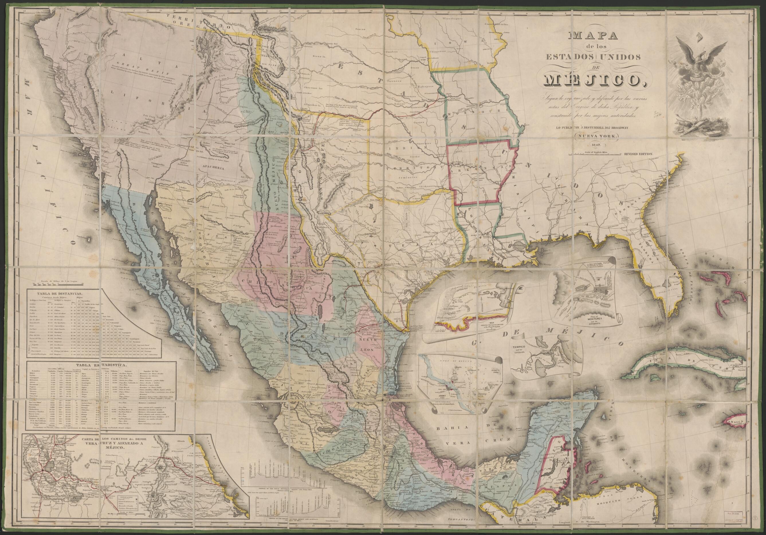
Mapa De Los Estados Unidos De Méjico : Segun Lo Organizado Y Definido Por Las Varias Actas Del Congreso De Dicha República Y Construido Por Las Mejores Autoridades 1847
- Regular price
-
$136.95 - Regular price
-
$131.95 - Sale price
-
$136.95
Buy one map, get any other map in our collection for 50% OFF! Add to cart to see discount.
Couldn't load pickup availability
About This Map
Discover the timeless beauty of our fine art quality printed reproduction of this antique map. Perfect for history enthusiasts, collectors, and interior decorators.
Restored with meticulous attention to detail by our team with over a decade of experience, this stunning reproduction captures the intricate artistry and historical significance of the original map.
Whether you're a collector or seeking a unique decor piece, this archival-quality map reproduction is a timeless addition to any space. Order now to bring history to life!
Old map of Mexico, Southwest, New, United States.Created by John Disturnell in 1847.
- Relief shown by hachures and spot heights.
- Area covered includes the southwestern part of the present United States.
- Handwritten in lower margin: 8th edition.
- Prime meridian: Washington.
- Includes distance and statistical tables, 2 profiles: Profile of the route between Mexico and Vera Cruz and Profile of the route between Mexico and Acapulco, and illustration.
- Inset maps: Map showing the battle grounds of the 8th and 9th May 1846 / by J.H. Eaton -- Chart of the Bay of Vera Cruz / drawn by order of V. Admiral Baudin -- Plan of Monterey and its environs -- Tampico and its environs.
- Eighth edition of J. Disturnell map. See A la Carte, Selected papers on Maps and Atlases, GA231.R5, pages 212-221 for various editions.
- When affixed to the cloth backing the map sheet was sectioned to 32 panels to enable folding.
- The map cover (marbled stiff-paper) is affixed to the cloth backing in 2 separate panels.
- Copy This map has some imperfections: fold lined, use-worn, foxed, torn at fold lines, annotated in red ink, hemmed at edges with green fabric. We'll do our best to restore the image before printing.
- For the best legibility, order your map in the original size or larger. Most maps have intricate detail and small text that is best appreciated when the print size hasn't been reduced.
- Sizes labeled "Fits a Standard Frame" will drop right into any frame that you purchase in that size. The sizes that we offer are commonly available online and at most retail stores.
- Our standard sizes are recommendations based on the aspect ratio of the original map, but still may require some added "white space" in one dimension to fit.
- Non-standard sizes will require custom framing, and we suggest taking your print to the frame shop of your choice after you receive it for the best results.
- Custom sizes are available, simply contact us for a quote.
Below is an approximation of the scale of a few standard sizes, and how they might appear in your space.
