
Map of the Strait of Magellan Developed by the Schouten and Le Maire Expedition, 1616. (Mapa Del Estrecho De Magallanes Elaborado Por La Expedición De Schouten Y Le Maire, 1616) 1622
- Regular price
-
$49.95 - Regular price
-
$34.95 - Sale price
-
$49.95
Buy one map, get any other map in our collection for 50% OFF! Add to cart to see discount.
Couldn't load pickup availability
About This Map
Discover the timeless beauty of our fine art quality printed reproduction of this antique map. Perfect for history enthusiasts, collectors, and interior decorators.
Restored with meticulous attention to detail by our team with over a decade of experience, this stunning reproduction captures the intricate artistry and historical significance of the original map.
Whether you're a collector or seeking a unique decor piece, this archival-quality map reproduction is a timeless addition to any space. Order now to bring history to life!
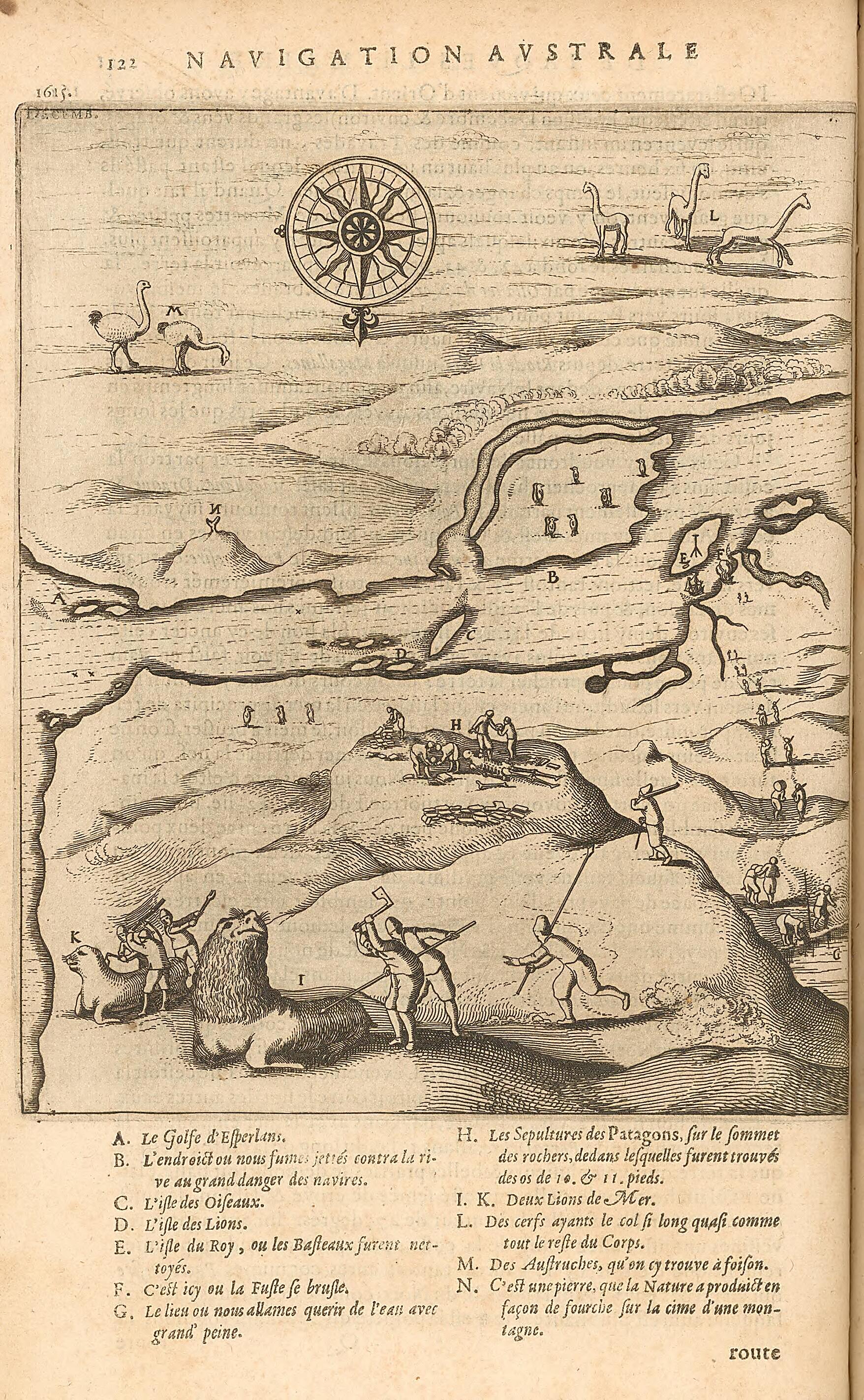
Old map of Argentina, Puerto Deseado, Santa Cruz.-1616) and Willem Corneliszoon Schouten (circa 1567--1625) set out in two ships, the Eendracht and the Hoorn, from the Dutch port of Texel, seeking to find a new route to the East Indies. They made landfall on the coast of South America in early December, at Port Desire (present-day Puerto Deseado, Argentina). This near-contemporary print shows the sailors from the Hoorn and the Eendracht at work on shore. Seeking to replenish their supplies after nearly six months at sea, the sailors found an abundance of marine life, nests of penguins and gulls filled with eggs, and large animals that they hunted for meat. In the foreground, sailors are seen killing sea lions using lances, axes, and knives. In the distance, other men can be seen investigating a burial site. The compass rose at the center indicates that the map is oriented with south at the top. Penguins, llamas, and ñandues (American ostriches) are shown at the top. After leaving Argentina in late January of 1616, Le Maire and Schouten became the first Europeans to round Cape Horn. The map is from a French translation, published in Amsterdam in 1622, of Historia general de los hechos de los Castellanos en las islas y tierra firma del Mar Oceano (General history of the deeds of the Castilians on the islands and mainland of the Ocean Sea) by the Spanish historian Antonio de Herrera (1559--1625).
Created by Antoine De Herrera Y Tordesillas, Jacob Le Maire, Willem Corneliszoon Schouten in 1622.
- Title devised, in English, by Library staff.
- "From: 'Description des Indes Occidentales, qu'on appelle aujourdhuy le Nouveau Monde' / par Antoine de Herrera ... ; translatée d'espagnol en françois. Amsterdam : chez Emanuel Colin de Thovoyon marchandt libraire ; Paris : Chez Michel Soly [distribuidor], 1622. 54 pages"--Note extracted from World Digital Library.
- Original resource extent: 1 map.
- Original resource at: National Library of Chile.
- Content in French.
- Description based on data extracted from World Digital Library, which may be extracted from partner institutions.
Map Subjects
1616 To 1622
Animals
Argentina
Exploration And Encounters
Hunting
Magellan Strait Of (Chile And Argentina)
Puerto Deseado
Sailors
Santa Cruz
Antoine De Herrera Y Tordesillas
Jacob Le Maire
Willem Corneliszoon Schouten
1622
- For the best legibility, order your map in the original size or larger. Most maps have intricate detail and small text that is best appreciated when the print size hasn't been reduced.
- Sizes labeled "Fits a Standard Frame" will drop right into any frame that you purchase in that size. The sizes that we offer are commonly available online and at most retail stores.
- Our standard sizes are recommendations based on the aspect ratio of the original map, but still may require some added "white space" in one dimension to fit.
- Non-standard sizes will require custom framing, and we suggest taking your print to the frame shop of your choice after you receive it for the best results.
- Custom sizes are available, simply contact us for a quote.
Below is an approximation of the scale of a few standard sizes, and how they might appear in your space.

