
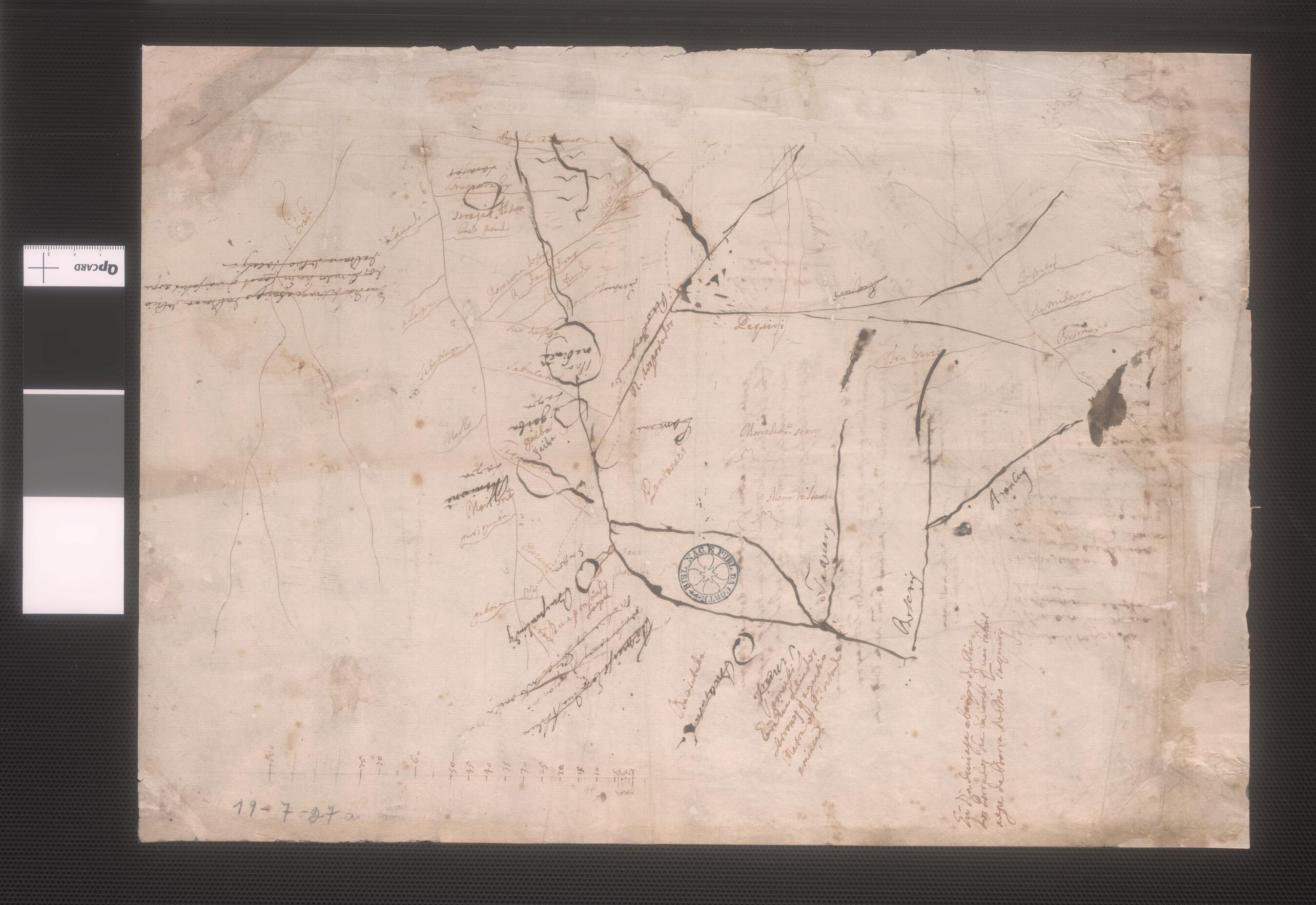
Primitive Map of the Upper Paraguay River and Its Tributaries Cuiaba, Porrudos and São Lourenco. (Mapa Rudimentar Do Alto Paraguai Com Seus Afluentes Entre Os Quais O Cuiabá E O Porrudos, Atual São Lourenço) 1720
- Regular price
-
$49.95 - Regular price
-
$34.95 - Sale price
-
$49.95
Shipping calculated at checkout.
Buy one map, get any other map in our collection for 50% OFF! Add to cart to see discount.
Couldn't load pickup availability
About This Map
Old map of Brazil.
drawn map from around 1720 shows the Upper Paraguay River and its tributaries, the Cuiaba, Porrudos, and São Lourenco rivers. The basin of the Upper Paraguay River is located in the present-day Brazilian states of Mato Grosso and Mato Grosso do Sul, and is the largest floodplain area in the world. This map subsequently played a role in establishing that Portugal occupied these inland territories and therefore could claim legal ownership under the terms of the 1750 Treaty of Madrid. The map was drawn with ferrogálica, an ink that at one time was widely used, but which corrodes the paper on which it is written, making surviving examples of such works rare. Ferrogálica is made up of four basic ingredients: tannic acid, ferrous sulfate, Arabica gum, and water. It starts as bluish-black, but becomes completely black when exposed to oxygen. Over time, it fades to a brownish color.
drawn map from around 1720 shows the Upper Paraguay River and its tributaries, the Cuiaba, Porrudos, and São Lourenco rivers. The basin of the Upper Paraguay River is located in the present-day Brazilian states of Mato Grosso and Mato Grosso do Sul, and is the largest floodplain area in the world. This map subsequently played a role in establishing that Portugal occupied these inland territories and therefore could claim legal ownership under the terms of the 1750 Treaty of Madrid. The map was drawn with ferrogálica, an ink that at one time was widely used, but which corrodes the paper on which it is written, making surviving examples of such works rare. Ferrogálica is made up of four basic ingredients: tannic acid, ferrous sulfate, Arabica gum, and water. It starts as bluish-black, but becomes completely black when exposed to oxygen. Over time, it fades to a brownish color.
- Title devised, in English, by Library staff.
- Original resource extent: 1 manuscript map ; Ferrogálica drawing ; 31 x 44 centimeters.
- Original resource at: National Library of Brazil.
- Content in Portuguese.
- Description based on data extracted from World Digital Library, which may be extracted from partner institutions.
Map Sizing Information
- For the best legibility, order your map in the original size or larger. Most maps have intricate detail and small text that is best appreciated when the print size hasn't been reduced.
- Sizes labeled "Fits a Standard Frame" will drop right into any frame that you purchase in that size. The sizes that we offer are commonly available online and at most retail stores.
- Our standard sizes are recommendations based on the aspect ratio of the original map, but still may require some added "white space" in one dimension to fit.
- Non-standard sizes will require custom framing, and we suggest taking your print to the frame shop of your choice after you receive it for the best results.
- Custom sizes are available, simply contact us for a quote.
Below is an approximation of the scale of a few standard sizes, and how they might appear in your space.
