
Humorous Map of Europe. (Mappa Humorístico Da Europa) 1914
- Regular price
-
$70.95 - Regular price
-
$65.95 - Sale price
-
$70.95
Buy one map, get any other map in our collection for 50% OFF! Add to cart to see discount.
Couldn't load pickup availability
About This Map
Discover the timeless beauty of our fine art quality printed reproduction of this antique map. Perfect for history enthusiasts, collectors, and interior decorators.
Restored with meticulous attention to detail by our team with over a decade of experience, this stunning reproduction captures the intricate artistry and historical significance of the original map.
Whether you're a collector or seeking a unique decor piece, this archival-quality map reproduction is a timeless addition to any space. Order now to bring history to life!
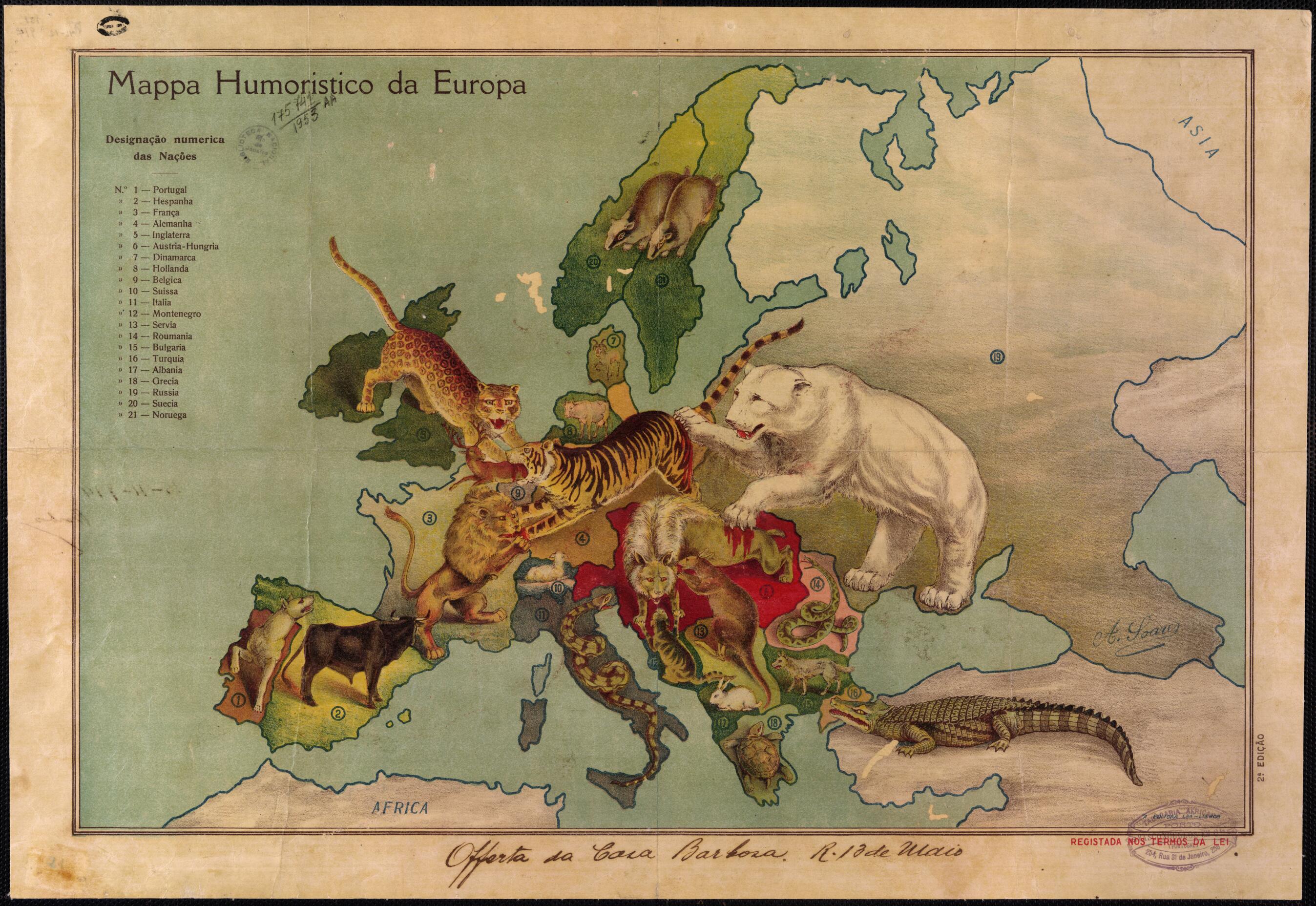
known Portuguese modernist painter and illustrator António Soares (1894-1978). The map can be seen as a condemnation of the powers of Europe, engaged as they were at that time in plunging the continent of Europe into the great conflagration that became World War I. Each of 21 countries is represented as an animal, with the names of the countries identified by a key in the upper-left corner of the map. The major powers all are depicted as large and ferocious beasts. Russia, a polar bear, claws at the wolf of Austria-Hungary, drawing blood, and at the German tiger, which is devouring the stag of Belgium. Great Britain, a leopard, and France, a lion, both are trying to engage the tiger. Serbia appears to be a rat, gnawing of the ear of the Austro-Hungarian wolf. Ottoman Turkey is portrayed as a particularly unattractive crocodile, while the smaller countries, many of them neutral, are represented by smaller and more pacific animals, such as the Albanian rabbit and the Greek turtle. Maps showing countries as animals had a long history in Europe, going back at least to the 16th and 17th centuries, when the Low Countries frequently were drawn in the form of a lion.Created by António Soares in 1914.
- Title devised, in English, by Library staff.
- "Second edition"--Note extracted from World Digital Library.
- Original resource extent: 1 map : color ; 36 x 52 centimeters.
- Original resource at: National Library of Brazil.
- Content in Portuguese.
- Description based on data extracted from World Digital Library, which may be extracted from partner institutions.
- For the best legibility, order your map in the original size or larger. Most maps have intricate detail and small text that is best appreciated when the print size hasn't been reduced.
- Sizes labeled "Fits a Standard Frame" will drop right into any frame that you purchase in that size. The sizes that we offer are commonly available online and at most retail stores.
- Our standard sizes are recommendations based on the aspect ratio of the original map, but still may require some added "white space" in one dimension to fit.
- Non-standard sizes will require custom framing, and we suggest taking your print to the frame shop of your choice after you receive it for the best results.
- Custom sizes are available, simply contact us for a quote.
Below is an approximation of the scale of a few standard sizes, and how they might appear in your space.
