
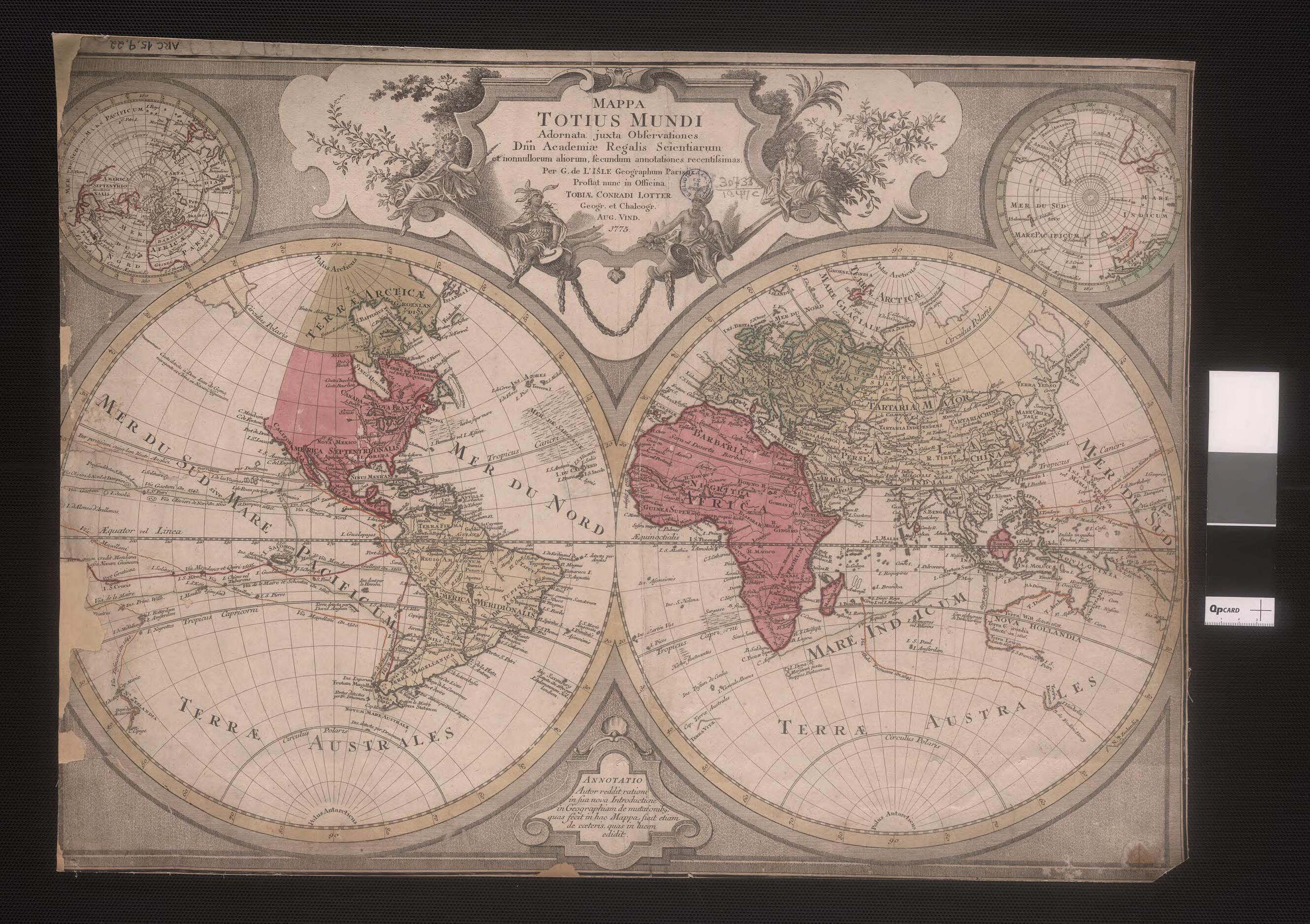
Map of the World. (Mappa Totius Mundi) 1775
- Regular price
-
$49.95 - Regular price
-
$34.95 - Sale price
-
$49.95
Buy one map, get any other map in our collection for 50% OFF! Add to cart to see discount.
Couldn't load pickup availability
About This Map
Discover the timeless beauty of our fine art quality printed reproduction of this antique map. Perfect for history enthusiasts, collectors, and interior decorators.
Restored with meticulous attention to detail by our team with over a decade of experience, this stunning reproduction captures the intricate artistry and historical significance of the original map.
Whether you're a collector or seeking a unique decor piece, this archival-quality map reproduction is a timeless addition to any space. Order now to bring history to life!
century Latin map of the world by the Augsburg map publisher Tobias Lotter (1717-77) is based on an earlier map by the French cartographer Guillaume de l'Isle (1675-1726). De l'Isle was among the group of French cartographers who wrested mapmaking preeminence from the Dutch in the late 17th century. De l'Isle was a child prodigy, having drawn his first map at age nine. He was trained in history and geography, as well as in mathematics and astronomy. He drew extensively on classical Arabic and Persian mapmakers and travel writers, and insisted on scientific precision in his design. In 1702, two years after the publication of his first atlas, he was elected a member of the Royal Academy of Science and in 1718 was appointed head royal geographer. Still uncharted at the time of this map's publication were the west coast of North America, the Arctic, and the eastern coast of Australia, which was known as New Holland. The map uses color tints and borders to demarcate divisions between the continents, as the sharp borders between Europe, Asia, and Africa highlight. In addition to mapping territory, de l'Isle's map presents voyages of exploration across the Pacific and Indian oceans.Created by Guillaume De L'isle in 1775.
- Title devised, in English, by Library staff.
- Original resource extent: Hand-colored engraved map.
- Original resource at: National Library of Brazil.
- Content in Latin.
- Description based on data extracted from World Digital Library, which may be extracted from partner institutions.
- For the best legibility, order your map in the original size or larger. Most maps have intricate detail and small text that is best appreciated when the print size hasn't been reduced.
- Sizes labeled "Fits a Standard Frame" will drop right into any frame that you purchase in that size. The sizes that we offer are commonly available online and at most retail stores.
- Our standard sizes are recommendations based on the aspect ratio of the original map, but still may require some added "white space" in one dimension to fit.
- Non-standard sizes will require custom framing, and we suggest taking your print to the frame shop of your choice after you receive it for the best results.
- Custom sizes are available, simply contact us for a quote.
Below is an approximation of the scale of a few standard sizes, and how they might appear in your space.

