
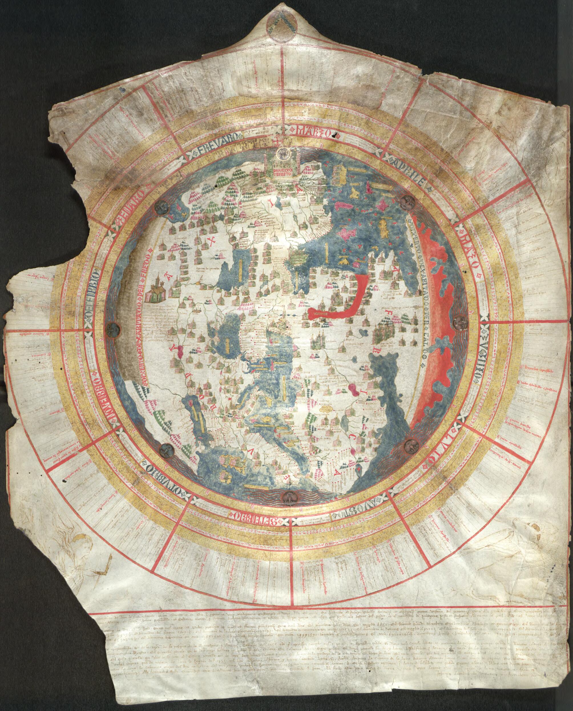
Mappamundi in 1452
- Regular price
-
$80.95 - Regular price
-
$75.95 - Sale price
-
$80.95
Buy one map, get any other map in our collection for 50% OFF! Add to cart to see discount.
Couldn't load pickup availability
About This Map
Discover the timeless beauty of our fine art quality printed reproduction of this antique map. Perfect for history enthusiasts, collectors, and interior decorators.
Restored with meticulous attention to detail by our team with over a decade of experience, this stunning reproduction captures the intricate artistry and historical significance of the original map.
Whether you're a collector or seeking a unique decor piece, this archival-quality map reproduction is a timeless addition to any space. Order now to bring history to life!
century Venetian geographer and cosmographer Giovanni Leardo, beyond the fact that three of his world maps have survived from late-medieval times, signed by their creator. This is the oldest world map held in the library of the American Geographical Society, and it is considered the finest example of a medieval mappamundi in the Western hemisphere. Leardo's two other maps, similar but not identical, are in Italy, at the Biblioteca Comunale in Verona and the Museo Civico in Vicenza. The map depicts the parts of the world known to Europeans in the late Middle Ages -- Europe, Asia, and Africa -- and, as on many medieval wall maps, shows Jerusalem at the center and east towards the top. Archer M. Huntington purchased and presented the map to the American Geographical Society in 1906. In 1928 the society published a full-size color facsimile and an accompanying text by John K. Wright, The Leardo Map of the World: 1452 or 1453. Wright's work was essentially a detailed description of the layout, names, and features on the map itself. Rand McNally also reproduced the map as a Christmas card in 1952.Created by Giovanni Leardo in 1452.
- Title devised, in English, by Library staff.
- Original resource extent: 1 map : color, manuscript ; 73 x 60 centimeters.
- Original resource at: University of Wisconsin-Milwaukee Libraries.
- Content in Italian.
- Description based on data extracted from World Digital Library, which may be extracted from partner institutions.
- For the best legibility, order your map in the original size or larger. Most maps have intricate detail and small text that is best appreciated when the print size hasn't been reduced.
- Sizes labeled "Fits a Standard Frame" will drop right into any frame that you purchase in that size. The sizes that we offer are commonly available online and at most retail stores.
- Our standard sizes are recommendations based on the aspect ratio of the original map, but still may require some added "white space" in one dimension to fit.
- Non-standard sizes will require custom framing, and we suggest taking your print to the frame shop of your choice after you receive it for the best results.
- Custom sizes are available, simply contact us for a quote.
Below is an approximation of the scale of a few standard sizes, and how they might appear in your space.

