
South Sea. Pacific Ocean. (Mar Pacifico. by Hessel Gerritsz. Met Octroy Van De E.H.M. Heeren De Staten Generael Der Vereenichde Nederlanden . Duytsche Mÿlen Vÿftien Voor Een Graedt) 1622
- Regular price
-
$236.95 - Regular price
-
$231.95 - Sale price
-
$236.95
Buy one map, get any other map in our collection for 50% OFF! Add to cart to see discount.
Couldn't load pickup availability
About This Map
Discover the timeless beauty of our fine art quality printed reproduction of this antique map. Perfect for history enthusiasts, collectors, and interior decorators.
Restored with meticulous attention to detail by our team with over a decade of experience, this stunning reproduction captures the intricate artistry and historical significance of the original map.
Whether you're a collector or seeking a unique decor piece, this archival-quality map reproduction is a timeless addition to any space. Order now to bring history to life!
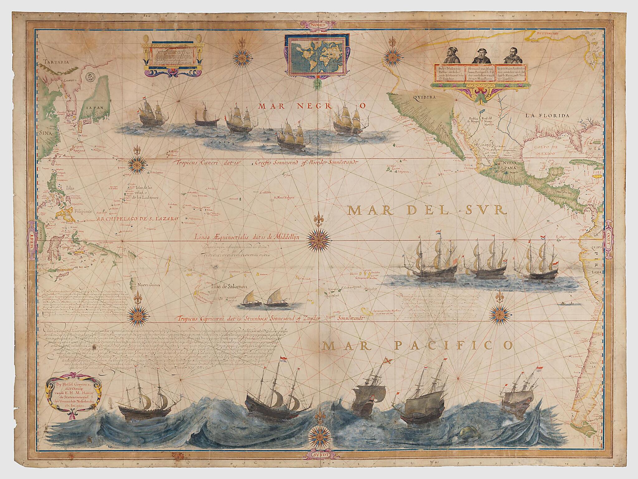
day California to the southern tip of South America; and, on the Atlantic side, the coast from the Tortugas to the east of Florida, as well as "Buttons Bay" (Hudson Bay). On the sides of the map, on the right and on the left, the latitude scales are graduated from 60° south to 60° north, with the equator and the Tropic of Cancer and the Tropic of Capricorn labeled. The map uses a system of rhumb lines of 932 millimeters in diameter with 16 secondary centers. There are seven wind roses. The coasts are ringed with colors; small islands are colored in flat tints. Three long captions in Dutch, two south of Timor, a third southeast of the Marquesas Islands, provide additional information about the map. At the top, cartouches show, on the left, scales in Dutch miles, Spanish leagues, and English leagues; and, on the right, three head-and-shoulder portraits of the explorers Balboa, Magellan, and Le Maire. A small planisphere (120 mm x 80 mm) is at the top center, the structure (increasing latitudes) and geographical plotting of which differ from those of the main map. California, a peninsula on the map, here is shown as an island, a design that appeared in mapping going back to 1510. The map is beautifully decorated with illustrations of vessels. In the North Pacific, four ships bearing Dutch flags are sailing towards America, while another heads to Asia. Off the coast of Peru, three Dutch ships sail to the west. The title "Mar del Sur, Mar Pacifico" is flanked with golden letters. At the bottom of the map, five ships are seen caught up in a storm. Also shown are whales and small indigenous boats. The border represents a golden frame, with indications of the cardinal points of the compass. In the left corner, a cartouche bound by ribbon and scrollwork bears the signature of the mapmaker. The date has been altered, probably by Gerritsz's successor; the first of the three Xs and the last two digits have been added, which results in 1634 instead of 1622, the original date.Created by Hessel Gerritsz in 1622.
- Title devised, in English, by Library staff.
- "On the sides of the map, on the right and on the left, the latitudes scales are graduated from 60° south to 60° north, 10° = 82 mm; indication of the equator and the tropics; system of rhumbs of 932 mm in diameter with 16 secondary centers; seven wind roses."--Note extracted from World Digital Library.
- Original resource extent: 1 map on 2 sheets, vellum : color ; 107 x 141 centimeters.
- Reference extracted from World Digital Library: Catherine Hofmann, Hélène Richard, Emmanuelle Vagnon, et al., The Golden Age of Maritime Maps: When Europe Discovered the World (Buffalo, NY: Firefly, 2013).|National Library of Australia, Mapping our World: Terra Incognita to Australia (Canberra: National Library of Australia, 2013).
- Original resource at: National Library of France.
- Content in Dutch and Spanish.
- Description based on data extracted from World Digital Library, which may be extracted from partner institutions.
Map Subjects
Coasts
Pacific Ocean
Hessel Gerritsz
1622
- For the best legibility, order your map in the original size or larger. Most maps have intricate detail and small text that is best appreciated when the print size hasn't been reduced.
- Sizes labeled "Fits a Standard Frame" will drop right into any frame that you purchase in that size. The sizes that we offer are commonly available online and at most retail stores.
- Our standard sizes are recommendations based on the aspect ratio of the original map, but still may require some added "white space" in one dimension to fit.
- Non-standard sizes will require custom framing, and we suggest taking your print to the frame shop of your choice after you receive it for the best results.
- Custom sizes are available, simply contact us for a quote.
Below is an approximation of the scale of a few standard sizes, and how they might appear in your space.

