
Masindi Port, Uganda, East Africa. (Masindi Port: Uganda, East Africa 1: 250,000) 1911
- Regular price
-
$70.95 - Regular price
-
$65.95 - Sale price
-
$70.95
Buy one map, get any other map in our collection for 50% OFF! Add to cart to see discount.
Couldn't load pickup availability
About This Map
Discover the timeless beauty of our fine art quality printed reproduction of this antique map. Perfect for history enthusiasts, collectors, and interior decorators.
Restored with meticulous attention to detail by our team with over a decade of experience, this stunning reproduction captures the intricate artistry and historical significance of the original map.
Whether you're a collector or seeking a unique decor piece, this archival-quality map reproduction is a timeless addition to any space. Order now to bring history to life!
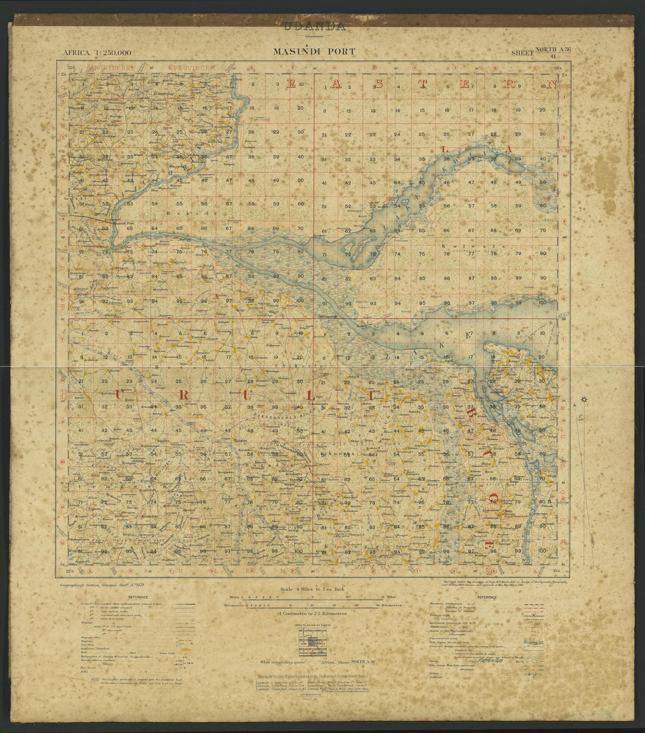
Old map of Masindi Port, Uganda, Western.This map of Masindi Port in Uganda was drawn by the Geographical Section of the General Staff of the British Army, based on a survey carried out in 1909 by the Uganda Topographical Survey, and printed at the War Office in London in 1911. Shown are international, kingdom or provincial, and county or district boundaries; railways (operational and projected); rivers and streams; swamps; wells, springs, and water holes; and other natural features. The map is extremely detailed and preserves much of the data captured in the survey, including trigonometrical points, heights above sea level in feet, and topographic contours, both measured and interpolated. A note at the lower left states: "The Country generally is covered with thin scattered bush. For the sake of clearness, only forest and thick bush are shown." Masindi Port is located on the Victoria Nile, which flows westward from Lake Victoria to Lake Kyoga and from there to Lake Albert. Steamboat navigation on the river was interrupted by the Karuma Falls and Murchison Falls. Travelers heading north on the Nile would disembark at Masindi Port, and then proceed overland to Butiaba, a port located on the eastern shore of Lake Albert. From there, they would board another steamboat and continue their journey on Lake Albert and up the Albert Nile, which issues from the lake. The map shows the major (first class) road heading westward from Masindi Port toward Lake Albert. The scale is 1:250,000.
Created by Great Britain. War Office. General Staff. Geographical Section, William Campbell Macfie, Uganda Topographical Survey in 1911.
- Title devised, in English, by Library staff.
- "From the Uganda National Fisheries Resources Research Institute. Digitized at the National Library of Uganda with support from the Carnegie Corporation of New York."--Note extracted from World Digital Library.
- Original resource extent: 1 map ; 64 x 57 centimeters.
- Original resource at: National Library of Uganda.
- Content in English.
- Description based on data extracted from World Digital Library, which may be extracted from partner institutions.
- For the best legibility, order your map in the original size or larger. Most maps have intricate detail and small text that is best appreciated when the print size hasn't been reduced.
- Sizes labeled "Fits a Standard Frame" will drop right into any frame that you purchase in that size. The sizes that we offer are commonly available online and at most retail stores.
- Our standard sizes are recommendations based on the aspect ratio of the original map, but still may require some added "white space" in one dimension to fit.
- Non-standard sizes will require custom framing, and we suggest taking your print to the frame shop of your choice after you receive it for the best results.
- Custom sizes are available, simply contact us for a quote.
Below is an approximation of the scale of a few standard sizes, and how they might appear in your space.

