
Maskat and Matrah In Oman, Arabia 1897
- Regular price
-
$49.95 - Regular price
-
$34.95 - Sale price
-
$49.95
Buy one map, get any other map in our collection for 50% OFF! Add to cart to see discount.
Couldn't load pickup availability
About This Map
Discover the timeless beauty of our fine art quality printed reproduction of this antique map. Perfect for history enthusiasts, collectors, and interior decorators.
Restored with meticulous attention to detail by our team with over a decade of experience, this stunning reproduction captures the intricate artistry and historical significance of the original map.
Whether you're a collector or seeking a unique decor piece, this archival-quality map reproduction is a timeless addition to any space. Order now to bring history to life!
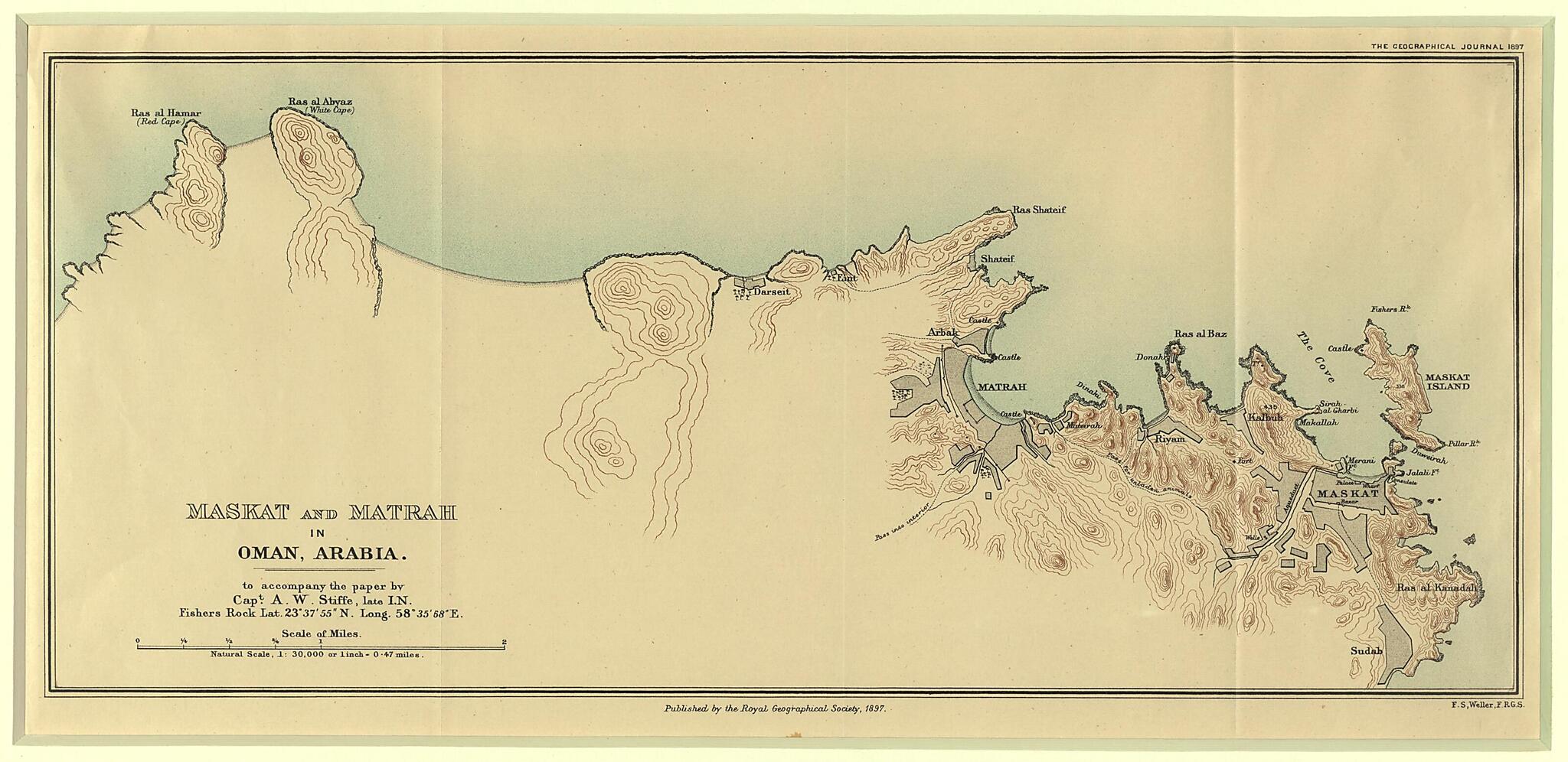
Old map of Masqat, Muscat, Muţra, Oman.scale topographic map of Matrah and Maskat (Masqat) made by Francis Sidney Weller (1849-1910), a fellow of the Royal Geographic Society, to accompany a paper by Captain Arthur William Stiffe (1831-1912). Stiffe served in the Indian Navy and later in the Royal Indian Marine. He was engineer in chief and electrician for the Indian government telegraph cables in the Persian Gulf (1864-79) and in 1890 was engineer in chief of the Halifax-Bermuda cable-laying expedition. Stiffe was the co-author of the famous Persian Gulf Pilot, incl. the Gulf of Oman navigation aids, which appeared in several editions between 1864 and 1898. Weller's father, Edward, was also a member of the Royal Geographical Society and was one of the first London map printers to adopt lithography. Francis Sidney Weller inherited his father's successful business and is best known now for his maps of British counties published in The Comprehensive Gazetteer of England and Wales, edited by J.H.F. Brabner and published in the 1890s. Topography is indicated on this map by contour lines although no information as to their height is given. Settled areas are indicated by grey shading. Palm trees indicate agricultural areas around the settlements. The map also shows important pathways and passes.
Created by Francis Sidney Weller in 1897.
- Title devised, in English, by Library staff.
- "As found in The Geographical Journal, 1897.|Map scale 1:30,000"--Note extracted from World Digital Library.
- Original resource extent: 1 map : color ; 19 x 43 centimeters.
- Original resource at: Qatar National Library.
- Content in English.
- Description based on data extracted from World Digital Library, which may be extracted from partner institutions.
Map Subjects
Coastal Settlements
Coasts
Masqat
Muscat
Muţra
Oman
Topographic Maps
Francis Sidney Weller
1897
- For the best legibility, order your map in the original size or larger. Most maps have intricate detail and small text that is best appreciated when the print size hasn't been reduced.
- Sizes labeled "Fits a Standard Frame" will drop right into any frame that you purchase in that size. The sizes that we offer are commonly available online and at most retail stores.
- Our standard sizes are recommendations based on the aspect ratio of the original map, but still may require some added "white space" in one dimension to fit.
- Non-standard sizes will require custom framing, and we suggest taking your print to the frame shop of your choice after you receive it for the best results.
- Custom sizes are available, simply contact us for a quote.
Below is an approximation of the scale of a few standard sizes, and how they might appear in your space.
