
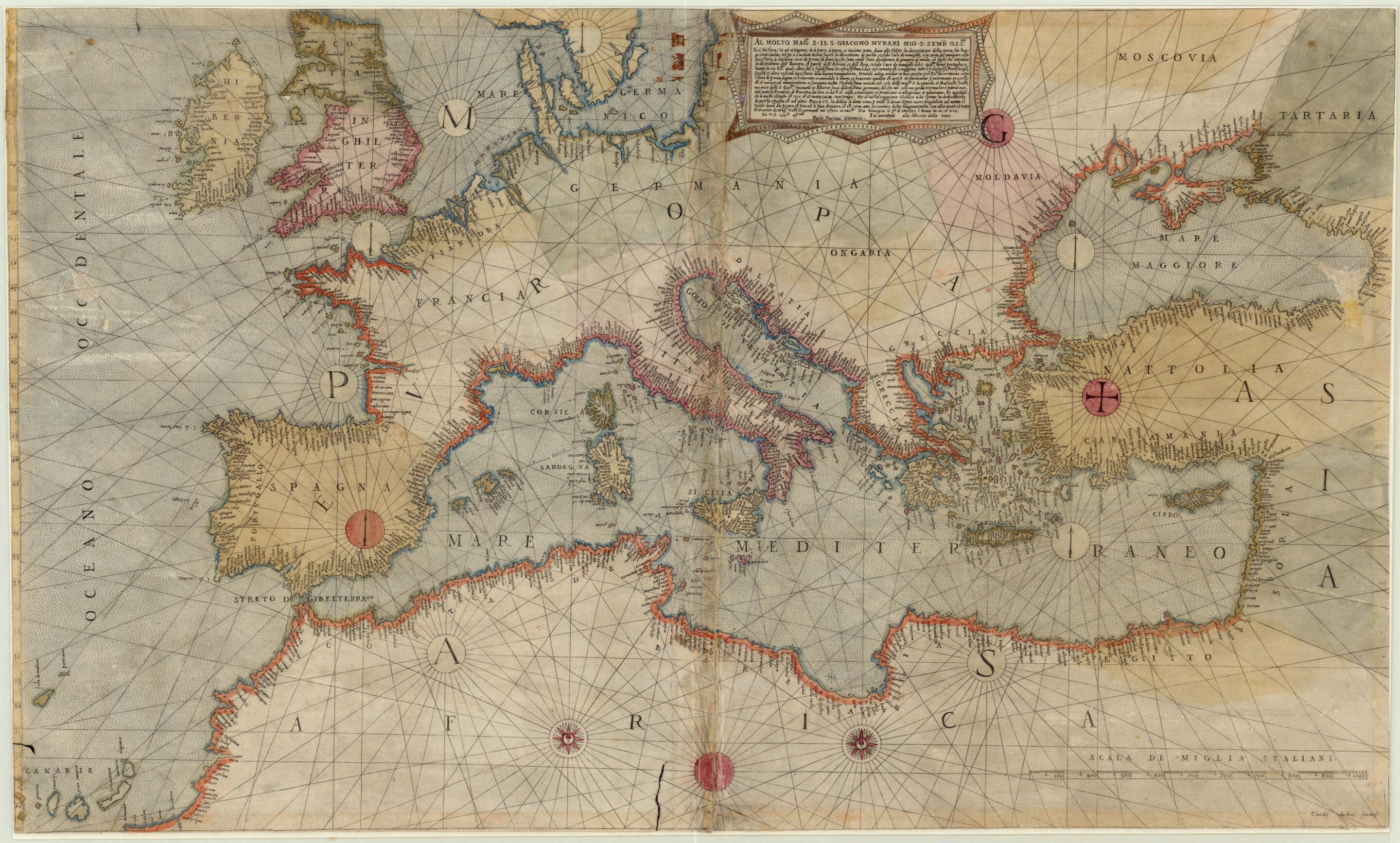
Mediterranean Sea Region 1569
- Regular price
-
$77.95 - Regular price
-
$72.95 - Sale price
-
$77.95
Buy one map, get any other map in our collection for 50% OFF! Add to cart to see discount.
Couldn't load pickup availability
About This Map
Discover the timeless beauty of our fine art quality printed reproduction of this antique map. Perfect for history enthusiasts, collectors, and interior decorators.
Restored with meticulous attention to detail by our team with over a decade of experience, this stunning reproduction captures the intricate artistry and historical significance of the original map.
Whether you're a collector or seeking a unique decor piece, this archival-quality map reproduction is a timeless addition to any space. Order now to bring history to life!
-74. Most of his maps appeared under the imprint of other publishers, including Giovanni Francesco Camocio, Ferrando Bertelli, and Bolognini Zaltieri in Venice and Claudio Duchetti in Rome-members of the Lafreri school of cartography, some of whose printing plates were still used well into the 17th century. Nominally a map of the Mediterranean Sea region, the map extends as far west as Ireland and north to much of Russia and the Black Sea (labeled as Mare Maggiore). The word portolan derives from portolano, meaning "related to ports or harbors." Portolan charts were often simple coastal outlines used in navigation with few, if any, inland features shown. The straight lines crisscrossing the chart represent the 32 directions, or headings, of the mariner's compass from a given point. Coastal place-names are written on the land side of the coastline so as not to obscure possible maritime dangers. Areas of political control are indicated by different colors along the coastline and in some cases by shading of the interior.Created by Paolo Forlani in 1569.
- Title devised, in English, by Library staff.
- Original resource extent: 1 map : color ; 50 x 84 centimeters.
- Original resource at: University of Wisconsin-Milwaukee Libraries.
- Content in Italian.
- Description based on data extracted from World Digital Library, which may be extracted from partner institutions.
- For the best legibility, order your map in the original size or larger. Most maps have intricate detail and small text that is best appreciated when the print size hasn't been reduced.
- Sizes labeled "Fits a Standard Frame" will drop right into any frame that you purchase in that size. The sizes that we offer are commonly available online and at most retail stores.
- Our standard sizes are recommendations based on the aspect ratio of the original map, but still may require some added "white space" in one dimension to fit.
- Non-standard sizes will require custom framing, and we suggest taking your print to the frame shop of your choice after you receive it for the best results.
- Custom sizes are available, simply contact us for a quote.
Below is an approximation of the scale of a few standard sizes, and how they might appear in your space.
