
Military Map of the Theater of War. (Mappa Militar Do Theatro Da Guerra) 1914
- Regular price
-
$86.95 - Regular price
-
$81.95 - Sale price
-
$86.95
Buy one map, get any other map in our collection for 50% OFF! Add to cart to see discount.
Couldn't load pickup availability
About This Map
Discover the timeless beauty of our fine art quality printed reproduction of this antique map. Perfect for history enthusiasts, collectors, and interior decorators.
Restored with meticulous attention to detail by our team with over a decade of experience, this stunning reproduction captures the intricate artistry and historical significance of the original map.
Whether you're a collector or seeking a unique decor piece, this archival-quality map reproduction is a timeless addition to any space. Order now to bring history to life!
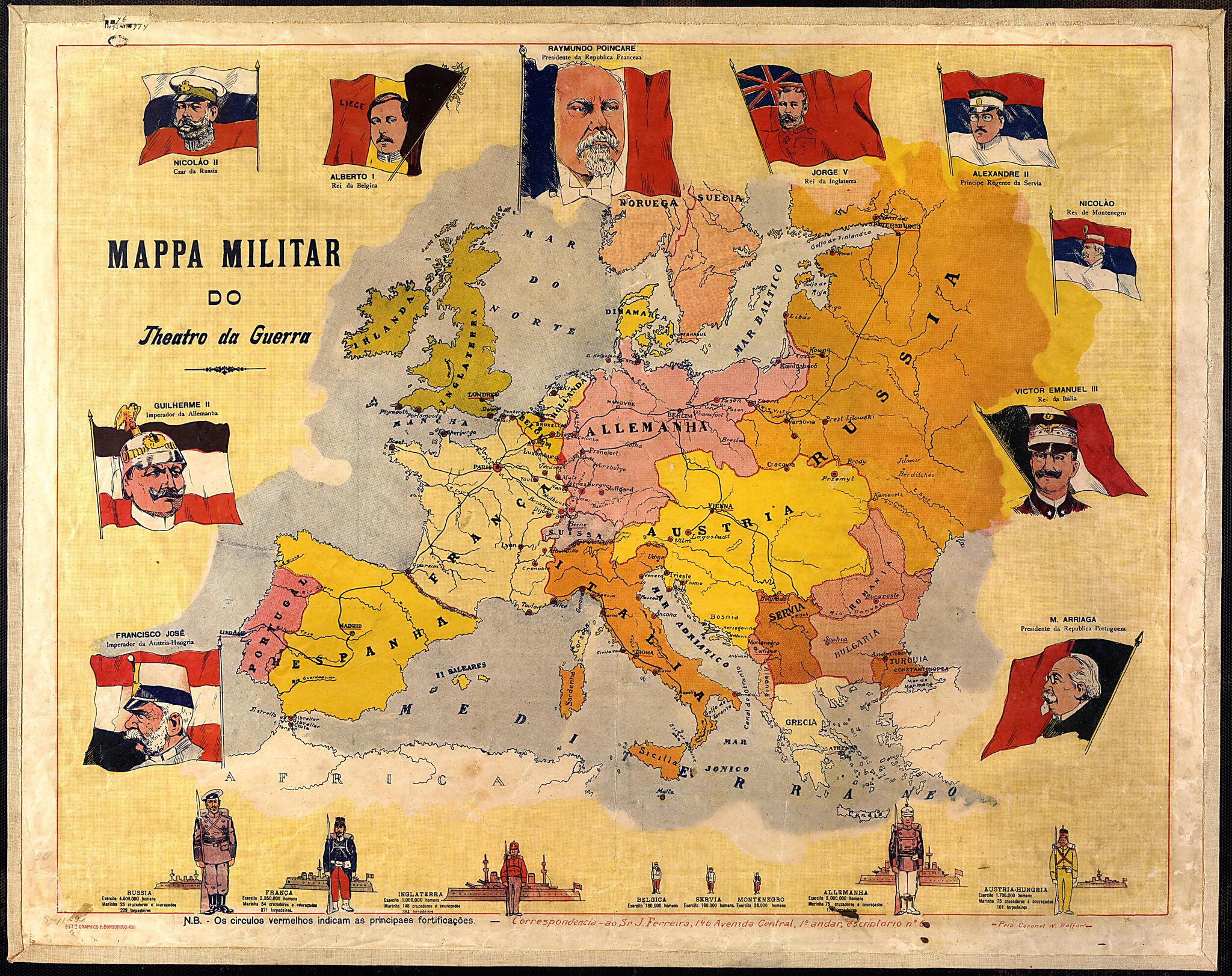
Hungary, Germany, Russia, Belgium, France, Great Britain, Serbia, Montenegro, Italy, and Portugal are shown. At the bottom of the map, figures are given for the size of the army and the navy of each of the powers, with the figures of a soldier in the national uniform and a ship for each country shown in different sizes to indicate the relative size of these forces. Although quite simple, the graphic is effective in showing the numerical preponderance of the Russian, German, and to some extent French armies, and the quantitative strength of the British navy. The names of capitals are underlined, and red dots are used to indicate the principal fortresses on the continent. This simple and colorful map also shows how different Europe looked in 1914 from what it was to become after the war and the Paris Peace Conference of 1919. Four empires-the German, Austro-Hungarian, Russian, and Ottoman Turkish-collapsed as a consequence of World War I, leading to the establishment of many more independent nation states. The war also hastened independence for Ireland, shown here as still part of the United Kingdom, and resulted in territorial changes in the border between Austria and Italy in favor of the latter.Created by W. Belfort, J. Ferreira in 1914.
- Title devised, in English, by Library staff.
- Original resource extent: 1 map : color ; 56 x 71.5 centimeters.
- Original resource at: National Library of Brazil.
- Content in Portuguese.
- Description based on data extracted from World Digital Library, which may be extracted from partner institutions.
Map Subjects
Flags
Kings And Rulers
World War
W. Belfort
J. Ferreira
1914
- For the best legibility, order your map in the original size or larger. Most maps have intricate detail and small text that is best appreciated when the print size hasn't been reduced.
- Sizes labeled "Fits a Standard Frame" will drop right into any frame that you purchase in that size. The sizes that we offer are commonly available online and at most retail stores.
- Our standard sizes are recommendations based on the aspect ratio of the original map, but still may require some added "white space" in one dimension to fit.
- Non-standard sizes will require custom framing, and we suggest taking your print to the frame shop of your choice after you receive it for the best results.
- Custom sizes are available, simply contact us for a quote.
Below is an approximation of the scale of a few standard sizes, and how they might appear in your space.

