
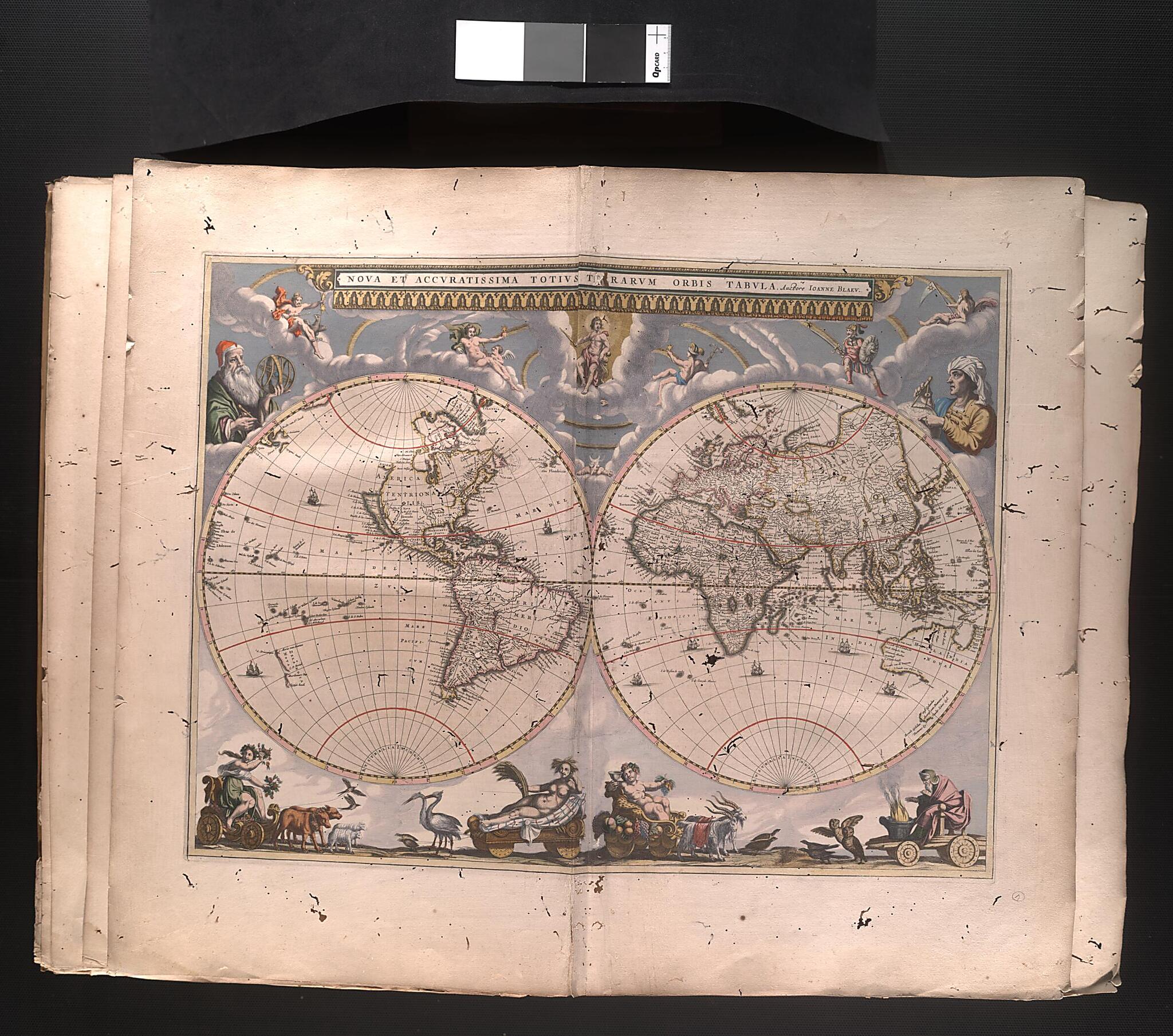
Modern and Completely Correct Map of the Entire World. (Nova Et Accuratissima Totius Terrarum Orbis Tabula) 1659
- Regular price
-
$88.95 - Regular price
-
$83.95 - Sale price
-
$88.95
Buy one map, get any other map in our collection for 50% OFF! Add to cart to see discount.
Couldn't load pickup availability
About This Map
Discover the timeless beauty of our fine art quality printed reproduction of this antique map. Perfect for history enthusiasts, collectors, and interior decorators.
Restored with meticulous attention to detail by our team with over a decade of experience, this stunning reproduction captures the intricate artistry and historical significance of the original map.
Whether you're a collector or seeking a unique decor piece, this archival-quality map reproduction is a timeless addition to any space. Order now to bring history to life!
17th century "modern and completely correct map" of the entire world was printed in Amsterdam by Joan Blaeu (1596-1673), a member of the Blaeu family that helped to define mapmaking during the Dutch golden age. Beginning in the 16th century, the Blaeu firm produced some of Europe's most renowned maps, globes, and atlases. After studying under Danish astronomer Tycho Brahe, Joan's father, Willem Blaeu (1571-1638), founded the company in 1596. In 1633 he was appointed official chartmaker to the Dutch East India Company, an office that passed to his son. This appointment gave the family access to the most up-to-date information provided by the seamen of the company, as well as proprietary rights to all existing plates and charts held by the company. Joan Blaeu capitalized on this monopoly to turn enormous profits for the firm. This world map was produced just three years before his capstone project, the 1662 Atlas maior. The map reveals the limitations of knowledge regarding the west coast of North America, the Arctic, and New Holland (present-day Australia). The Blaeu business flourished until 1672, when a fire destroyed the firm's equipment, plates, and stock. Joan died a year later.Created by Joan Blaeu in 1659.
- Title devised, in English, by Library staff.
- Original resource extent: Hand colored engraving.
- Original resource at: National Library of Brazil.
- Content in Latin.
- Description based on data extracted from World Digital Library, which may be extracted from partner institutions.
Map Subjects
World Maps
Joan Blaeu
1659
- For the best legibility, order your map in the original size or larger. Most maps have intricate detail and small text that is best appreciated when the print size hasn't been reduced.
- Sizes labeled "Fits a Standard Frame" will drop right into any frame that you purchase in that size. The sizes that we offer are commonly available online and at most retail stores.
- Our standard sizes are recommendations based on the aspect ratio of the original map, but still may require some added "white space" in one dimension to fit.
- Non-standard sizes will require custom framing, and we suggest taking your print to the frame shop of your choice after you receive it for the best results.
- Custom sizes are available, simply contact us for a quote.
Below is an approximation of the scale of a few standard sizes, and how they might appear in your space.

