
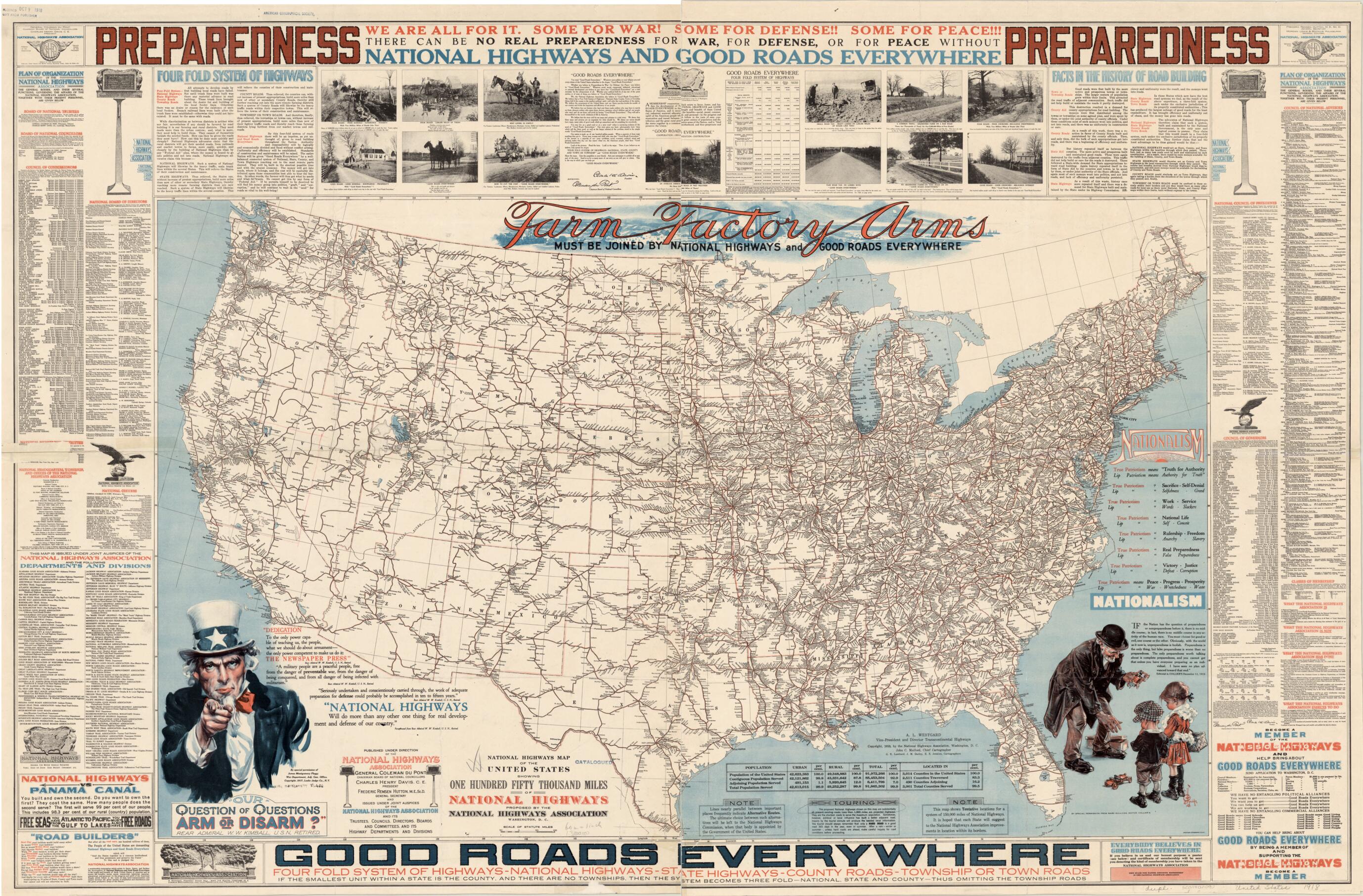
National Highways Map of the United States. (National Highways Map of the United States: Showing One Hundred Fifty Thousand Miles of National Highways Proposed by the National Highways Association) 1918
- Regular price
-
$92.95 - Regular price
-
$87.95 - Sale price
-
$92.95
Buy one map, get any other map in our collection for 50% OFF! Add to cart to see discount.
Couldn't load pickup availability
About This Map
Discover the timeless beauty of our fine art quality printed reproduction of this antique map. Perfect for history enthusiasts, collectors, and interior decorators.
Restored with meticulous attention to detail by our team with over a decade of experience, this stunning reproduction captures the intricate artistry and historical significance of the original map.
Whether you're a collector or seeking a unique decor piece, this archival-quality map reproduction is a timeless addition to any space. Order now to bring history to life!
Old map of United States of America.mile (241,402-kilometer) network of roads proposed by the NHA. Under the slogan "Good roads for everyone!" the NHA advocated a "four-fold system" of roads that would include national highways to be built and maintained by the federal government, and systems of state, county, and township or town roads. The map associates the building of roads with national defense and "preparedness" for U.S. involvement in World War I, as symbolized by James Montgomery Flagg's iconic figure of Uncle Sam in the lower left. The NHA was established in 1911 to promote the development of an improved national road network in the United States. It was one of many groups to grow out of the Good Roads Movement, which was begun in the 1880s by bicyclists interested in improving the nation's roads. At that time, local governments were mainly responsible for building and maintaining roads, which were primarily used by farmers to transport goods to market or to railroad terminals for long-distance transport. Road conditions could vary drastically, and often even well-kept roads would simply feed into rutted paths. The photographs on the map contrast the economic and social costs of poor roads with the benefits of improvements. The map includes lists of the NHA's officers and affiliates, information about the NHA proposal, and an appeal to the public to support the organization and its goals.
Created by American Lithographic Company, James M. (James Morrison) Darley, E. E. Jenkins, John C. Mulford, National Highways Association in 1918.
- Title devised, in English, by Library staff.
- "Scale 1:3,800,000"--Note extracted from World Digital Library.
- Original resource extent: 1 map : color ; 75 x 124 centimeters.
- Original resource at: University of Wisconsin-Milwaukee Libraries.
- Content in English.
- Description based on data extracted from World Digital Library, which may be extracted from partner institutions.
- For the best legibility, order your map in the original size or larger. Most maps have intricate detail and small text that is best appreciated when the print size hasn't been reduced.
- Sizes labeled "Fits a Standard Frame" will drop right into any frame that you purchase in that size. The sizes that we offer are commonly available online and at most retail stores.
- Our standard sizes are recommendations based on the aspect ratio of the original map, but still may require some added "white space" in one dimension to fit.
- Non-standard sizes will require custom framing, and we suggest taking your print to the frame shop of your choice after you receive it for the best results.
- Custom sizes are available, simply contact us for a quote.
Below is an approximation of the scale of a few standard sizes, and how they might appear in your space.
