
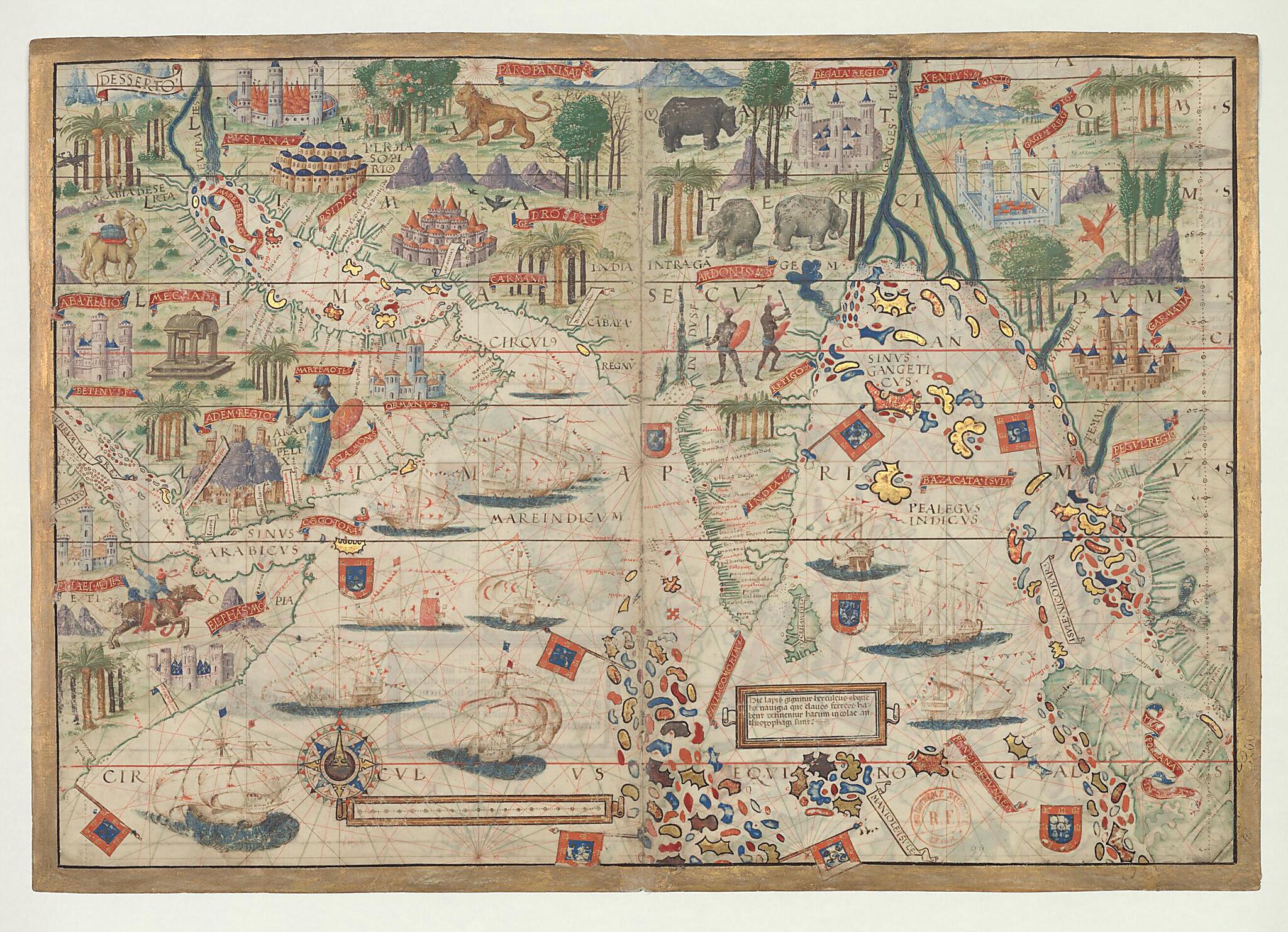
Nautical Atlas of the World, Folio 3 Recto, Northern Indian Ocean With Arabia and India and Folio 3 Verso, Southern Indian Ocean With Insulindia On the Left, and Madagascar On the Right 1519
- Regular price
-
$177.95 - Regular price
-
$172.95 - Sale price
-
$177.95
Buy one map, get any other map in our collection for 50% OFF! Add to cart to see discount.
Couldn't load pickup availability
About This Map
Discover the timeless beauty of our fine art quality printed reproduction of this antique map. Perfect for history enthusiasts, collectors, and interior decorators.
Restored with meticulous attention to detail by our team with over a decade of experience, this stunning reproduction captures the intricate artistry and historical significance of the original map.
Whether you're a collector or seeking a unique decor piece, this archival-quality map reproduction is a timeless addition to any space. Order now to bring history to life!
Old map of Bahrain, Bangladesh, India, Iran, Islamic Republic of, Kuwait, Madagascar, Malaysia, Mozambique, Myanmar, Oman, Pakistan, Qatar, Saudi Arabia, Somalia, Sri Lanka, United Arab Emirates, Yemen.names, heraldic shields and flags, and vessels flying either the Portuguese Cross of the Order of Christ or the Ottoman crescent. The atlas takes its name from Emmanuel Miller, who purchased it in 1855 from a bookseller in Santarém, Portugal. Miller's widow sold it to the National Library of France in 1897.
Created by António De Holanda, Lopo Homem, King of Portugal Manuel I, Jorge Reinel, Pedro Reinel in 1519.
- Title devised, in English, by Library staff.
- Original resource extent: 2 maps, 4 pages, vellum : illustrations ; 42 x 59 centimeters.
- Reference extracted from World Digital Library: Catherine Hofmann, Hélène Richard, Emmanuelle Vagnon, et al., The Golden Age of Maritime Maps: When Europe Discovered the World (Buffalo, NY: Firefly, 2013).
- Original resource at: National Library of France.
- Content in Latin.
- Description based on data extracted from World Digital Library, which may be extracted from partner institutions.
Map Subjects
Bahrain
Bangladesh
Coasts
India
Indian Ocean
Iran Islamic Republic Of
Kuwait
Madagascar
Malaysia
Mozambique
Myanmar
Oman
Pakistan
Portolan Charts
Qatar
Saudi Arabia
Somalia
Sri Lanka
United Arab Emirates
Yemen
António De Holanda
Lopo Homem
King Of Portugal Manuel I
Jorge Reinel
Pedro Reinel
1519
- For the best legibility, order your map in the original size or larger. Most maps have intricate detail and small text that is best appreciated when the print size hasn't been reduced.
- Sizes labeled "Fits a Standard Frame" will drop right into any frame that you purchase in that size. The sizes that we offer are commonly available online and at most retail stores.
- Our standard sizes are recommendations based on the aspect ratio of the original map, but still may require some added "white space" in one dimension to fit.
- Non-standard sizes will require custom framing, and we suggest taking your print to the frame shop of your choice after you receive it for the best results.
- Custom sizes are available, simply contact us for a quote.
Below is an approximation of the scale of a few standard sizes, and how they might appear in your space.

