
Nautical Atlas of the World, Folio 5 Recto, Southwestern Atlantic Ocean With Brazil 1519
- Regular price
-
$173.95 - Regular price
-
$168.95 - Sale price
-
$173.95
Buy one map, get any other map in our collection for 50% OFF! Add to cart to see discount.
Couldn't load pickup availability
About This Map
Discover the timeless beauty of our fine art quality printed reproduction of this antique map. Perfect for history enthusiasts, collectors, and interior decorators.
Restored with meticulous attention to detail by our team with over a decade of experience, this stunning reproduction captures the intricate artistry and historical significance of the original map.
Whether you're a collector or seeking a unique decor piece, this archival-quality map reproduction is a timeless addition to any space. Order now to bring history to life!
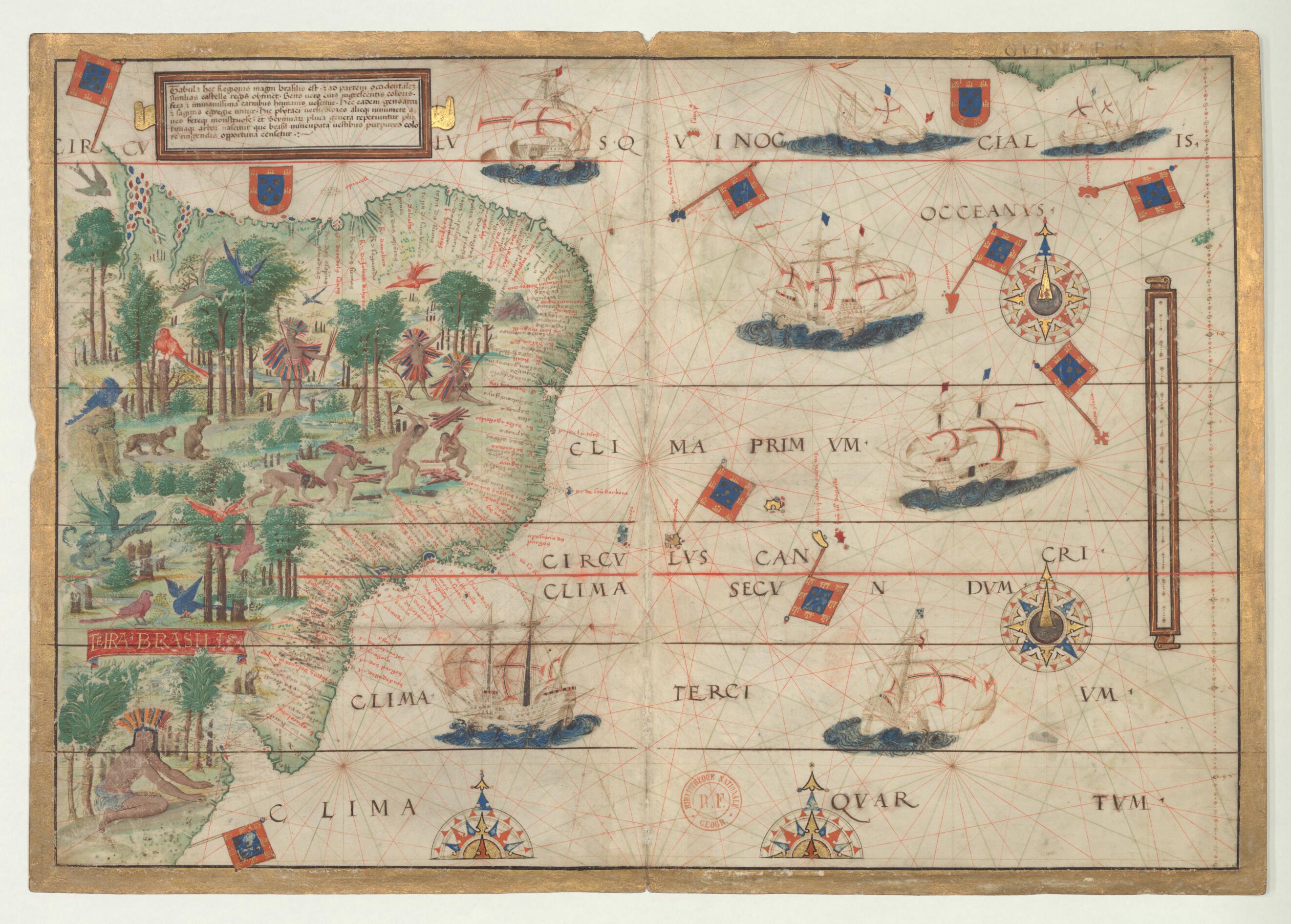
Old map of Brazil.The map presented here is from the Miller Atlas in the collections of the National Library of France. Produced for King Manuel I of Portugal in 1519 by cartographers Pedro Reinel, his son Jorge Reinel, and Lopo Homem and miniaturist António de Holanda, the atlas contains eight maps on six loose sheets, painted on both sides. The maps were richly decorated and illuminated by António de Holanda, a Dutch native who had been in Portugal for nearly ten years. The illustrations include ornate images of castles, towns, and architectural wonders; views of forests and other vegetation; and depictions of native peoples and animals. The shapes of some towns and coastlines are quite detailed. For other parts of the world about which Europeans still had limited knowledge, geographic details are drawn from the cartographer's imagination or informed by views that originated with Ptolemy. This map (folio 5 recto in the atlas) shows the southwestern Atlantic Ocean with Brazil; folio 5 verso is blank. The people of Brazil are shown as naked, or almost so, collecting wood or preparing for a hunt, and watched by exotic birds and beasts. A cartouche states that the Brazilians are "savage and very brutal." The atlas takes its name from Emmanuel Miller, who purchased it in 1855 from a bookseller in Santarém, Portugal. Miller's widow sold it to the National Library of France in 1897.
Created by António De Holanda, Lopo Homem, King of Portugal Manuel I, Jorge Reinel, Pedro Reinel in 1519.
- Title devised, in English, by Library staff.
- Original resource extent: 1 map, 2 pages, vellum : illustrations ; 42 x 59 centimeters.
- Reference extracted from World Digital Library: Catherine Hofmann, Hélène Richard, Emmanuelle Vagnon, et al., The Golden Age of Maritime Maps: When Europe Discovered the World (Buffalo, NY: Firefly, 2013).
- Original resource at: National Library of France.
- Content in Latin.
- Description based on data extracted from World Digital Library, which may be extracted from partner institutions.
- For the best legibility, order your map in the original size or larger. Most maps have intricate detail and small text that is best appreciated when the print size hasn't been reduced.
- Sizes labeled "Fits a Standard Frame" will drop right into any frame that you purchase in that size. The sizes that we offer are commonly available online and at most retail stores.
- Our standard sizes are recommendations based on the aspect ratio of the original map, but still may require some added "white space" in one dimension to fit.
- Non-standard sizes will require custom framing, and we suggest taking your print to the frame shop of your choice after you receive it for the best results.
- Custom sizes are available, simply contact us for a quote.
Below is an approximation of the scale of a few standard sizes, and how they might appear in your space.

