
Nautical Atlas of the World, Folio 6 Recto, North Atlantic Ocean in 1519
- Regular price
-
$211.95 - Regular price
-
$206.95 - Sale price
-
$211.95
Buy one map, get any other map in our collection for 50% OFF! Add to cart to see discount.
Couldn't load pickup availability
About This Map
Discover the timeless beauty of our fine art quality printed reproduction of this antique map. Perfect for history enthusiasts, collectors, and interior decorators.
Restored with meticulous attention to detail by our team with over a decade of experience, this stunning reproduction captures the intricate artistry and historical significance of the original map.
Whether you're a collector or seeking a unique decor piece, this archival-quality map reproduction is a timeless addition to any space. Order now to bring history to life!
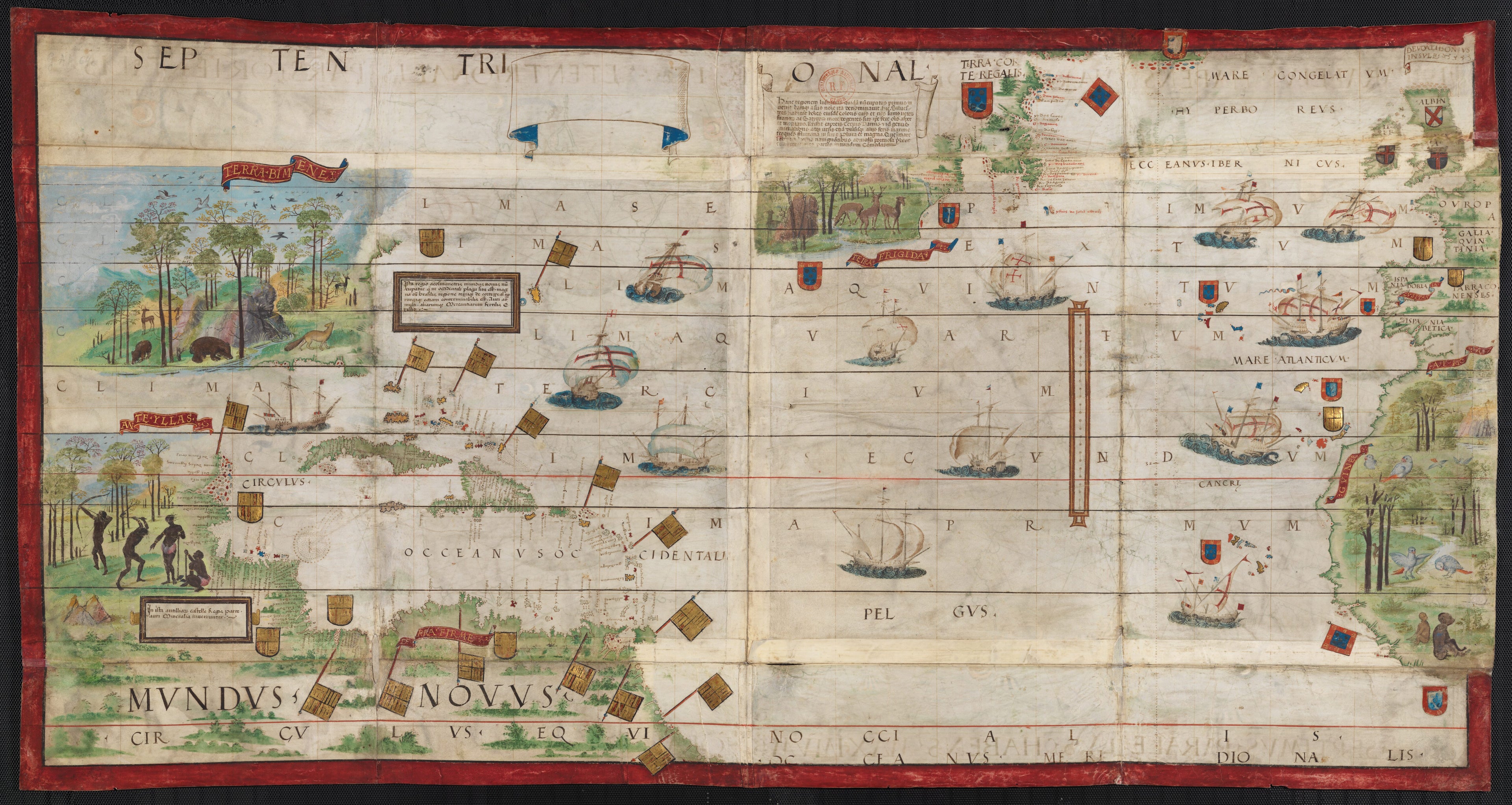
day southeast Liberia), as well as the British Isles, the Azores, the Canary Islands, and the Cape Verde Islands. The coasts of the Americas are shown in three sections: from Labrador to Acadia (present-day southeast Maine) with nomenclature for Newfoundland only (Terra Corte Regalis); from Virginia to the Gulf of the Mexico (Terra Bimenes, then an indigenous name for Florida), without nomenclature; and from the Yucatan and Cuba (Ante Ylläs) to the Mundus Novus (New World) of South America. The map has no rhumb lines, but only a grid corresponding to the north-south and east-west rhumbs. There is no wind rose. The map is rich in nomenclature for the coast of Guyana and the West Indies. Nomenclature along the coasts is in black and red cursive script; nomenclature on the seas is in black capital letters. At the top, a wide cartouche shaped like a streamer is left blank; on its right, another scroll cartouche contains text. Close to Florida is another cartouche surrounded by a brown frame with threads of gold with a caption. In Central America, there is a similar cartridge with the caption, Antilliarz ista In Castelle Regis parte / auri Mineralia inveniuntur (This [place called] Antilliarz is in the Kingdom of Castile / gold ores are found there). The map is rich in decoration. Mountains are seen in perspective. Landscapes with animals are shown in Africa, Acadia, and Florida. In Central America, dark-skinned natives are depicted hunting with arrows and working the soil. Spanish flags and shields west of the center fold separate Newfoundland from Florida and Central America. Portuguese flags are planted on Newfoundland, along the African coast, and in Portugal; Spanish flags mark the Canary Islands. Nine of the 13 ships on the map fly the Portuguese Cross of the Order of Christ as they traverse the ocean. The map is bordered on three sides by a red box outlined in black. The atlas takes its name from Emmanuel Miller, who purchased it in 1855 from a bookseller in Santarém, Portugal. Miller's widow sold it to the National Library of France in 1897.Created by António De Holanda, Lopo Homem, King of Portugal Manuel I, Jorge Reinel, Pedro Reinel in 1519.
- Title devised, in English, by Library staff.
- "Scales of lengths in the Atlantic Ocean 24 divisions = 154 millimeters, five divisions = 32 millimeters; scale of latitudes on the right of the scale of lengths and off the Azores, graduated from 64° north to 5° south; ten degrees = 86 millimeters; no indication of longitude."--Note extracted from World Digital Library.
- Original resource extent: 1 map, 2 pages, vellum : illustrations ; 118 x 61 centimeters.
- Reference extracted from World Digital Library: Catherine Hofmann, Hélène Richard, Emmanuelle Vagnon, et al., The Golden Age of Maritime Maps: When Europe Discovered the World (Buffalo, NY: Firefly, 2013).
- Original resource at: National Library of France.
- Content in Latin.
- Description based on data extracted from World Digital Library, which may be extracted from partner institutions.
- For the best legibility, order your map in the original size or larger. Most maps have intricate detail and small text that is best appreciated when the print size hasn't been reduced.
- Sizes labeled "Fits a Standard Frame" will drop right into any frame that you purchase in that size. The sizes that we offer are commonly available online and at most retail stores.
- Our standard sizes are recommendations based on the aspect ratio of the original map, but still may require some added "white space" in one dimension to fit.
- Non-standard sizes will require custom framing, and we suggest taking your print to the frame shop of your choice after you receive it for the best results.
- Custom sizes are available, simply contact us for a quote.
Below is an approximation of the scale of a few standard sizes, and how they might appear in your space.
