
Nautical Atlas of the World, Folio 6 Verso, the Mediterranean Sea in 1519
- Regular price
-
$209.95 - Regular price
-
$204.95 - Sale price
-
$209.95
Buy one map, get any other map in our collection for 50% OFF! Add to cart to see discount.
Couldn't load pickup availability
About This Map
Discover the timeless beauty of our fine art quality printed reproduction of this antique map. Perfect for history enthusiasts, collectors, and interior decorators.
Restored with meticulous attention to detail by our team with over a decade of experience, this stunning reproduction captures the intricate artistry and historical significance of the original map.
Whether you're a collector or seeking a unique decor piece, this archival-quality map reproduction is a timeless addition to any space. Order now to bring history to life!
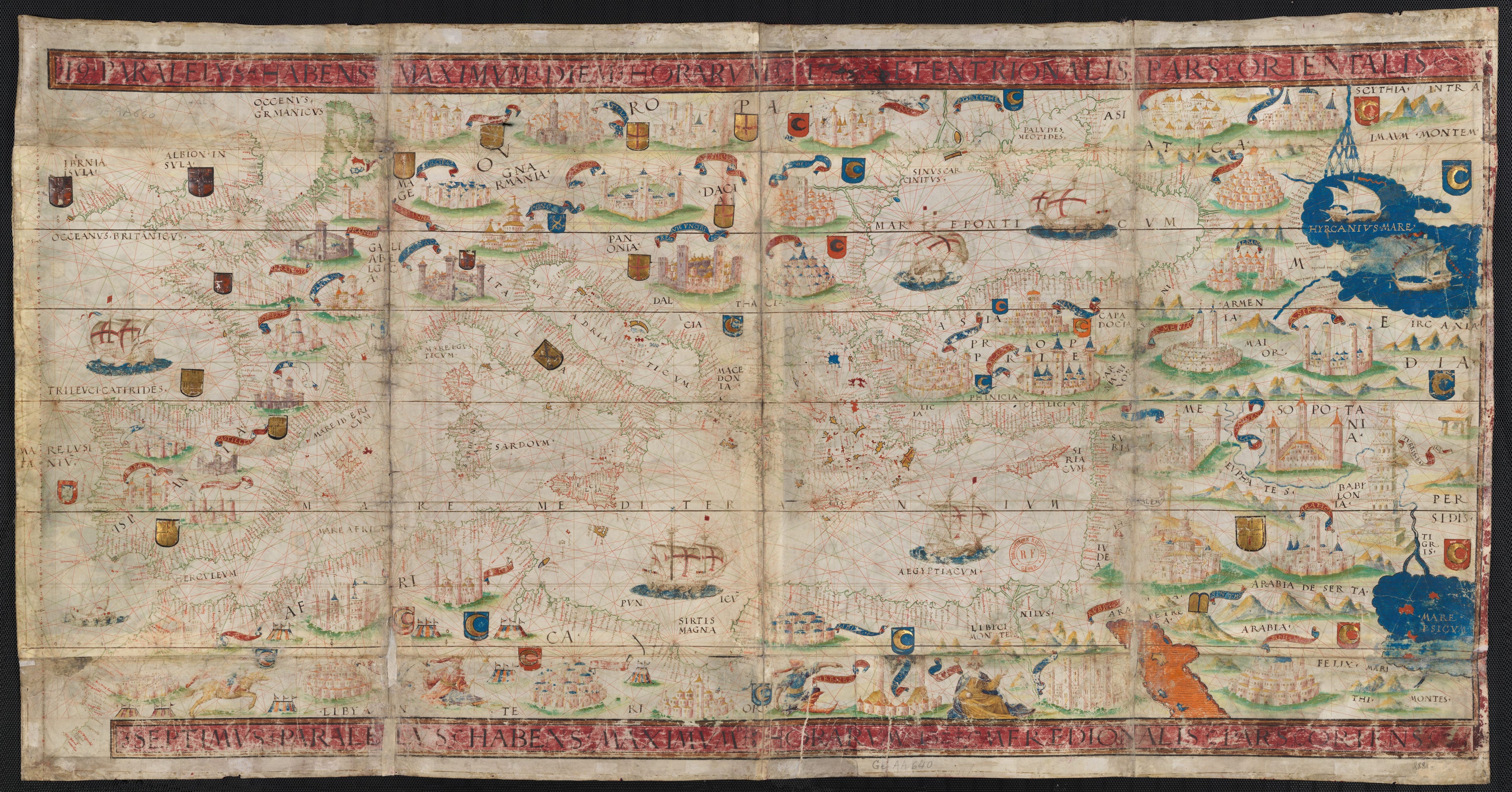
The map presented here is from the Miller Atlas in the collections of the National Library of France. Produced for King Manuel I of Portugal in 1519 by cartographers Pedro Reinel, his son Jorge Reinel, and Lopo Homem and miniaturist António de Holanda, the atlas contains eight maps on six loose sheets, painted on both sides. This map (folio 6 verso in the atlas) shows the Mediterranean Sea. The region represented comprises the European coasts from Jutland to the Caucasus. The nomenclature starts at Frissa (Friesland) and runs across the southern coasts of England and Ireland. The Mediterranean and Atlantic coasts are shown as far west as Cape Bojador (Ansulim). Also shown are the Caspian Sea and the northern parts of the Red Sea and the Persian Gulf. The nomenclature that spreads out from the eastern coasts is in black and red cursive; the names of regions are in black capitals. The names of provinces are in golden letters on red and blue streamers. The map contains very rich decoration similar to that in the other maps of the atlas: the Red Sea is shown in in red, the Caspian Sea and Persian Gulf in blue. Coasts are ringed with colors, islands with flat tints and gold. Rivers are in blue and green. Mountain ranges are shown in colors and in cavalier view. The map has about 50 miniatures of cities in cavalier view, with no apparent attempt at accuracy. Other objects depicted are the cross of Golgotha overlooking Jerusalem, the Tables of the Law on Mount Sinai, and the Tower of Babel between the Tigris and Euphrates Rivers. In Africa, eight tents with flags and four individuals are shown, one of whom is on horseback. On the oceans are eight vessels, five of which bear the Portuguese Cross of the Order of Christ. The map has red and gold borders on three edges. A scale of lengths in an upright position is displayed east of the Azores. The left edge of the map contains a scale of latitudes from 28° north to 59° north. Each degree is divided into four parts with black dots and in three parts with red dots. The middle of each degree is indicated with a red circle. A draft of gradation in longitudes was attempted along parallels 33° 40', 43° 30' and 50° 50' where degrees are respectively equivalent to 18 millimeters (mm), 16.3 mm, 14.7 mm, and 12 mm. The origin of the longitudes lies outside of the map of the Mediterranean Basin, on the map of the Azores at 2° 16' on the latitude scale, which is 2° from the meridian of Cape Saint Vincent. The atlas takes its name from Emmanuel Miller, who purchased it in 1855 from a bookseller in Santarém, Portugal. Miller's widow sold it to the National Library of France in 1897.Created by António De Holanda, Lopo Homem, King of Portugal Manuel I, Jorge Reinel, Pedro Reinel in 1519.
- Title devised, in English, by Library staff.
- Original resource extent: 1 map, vellum : illuminated ; 118 x 61 centimeters.
- Reference extracted from World Digital Library: Catherine Hofmann, Hélène Richard, Emmanuelle Vagnon, et al., The Golden Age of Maritime Maps: When Europe Discovered the World (Buffalo, NY: Firefly, 2013).
- Original resource at: National Library of France.
- Content in Latin.
- Description based on data extracted from World Digital Library, which may be extracted from partner institutions.
- For the best legibility, order your map in the original size or larger. Most maps have intricate detail and small text that is best appreciated when the print size hasn't been reduced.
- Sizes labeled "Fits a Standard Frame" will drop right into any frame that you purchase in that size. The sizes that we offer are commonly available online and at most retail stores.
- Our standard sizes are recommendations based on the aspect ratio of the original map, but still may require some added "white space" in one dimension to fit.
- Non-standard sizes will require custom framing, and we suggest taking your print to the frame shop of your choice after you receive it for the best results.
- Custom sizes are available, simply contact us for a quote.
Below is an approximation of the scale of a few standard sizes, and how they might appear in your space.
