
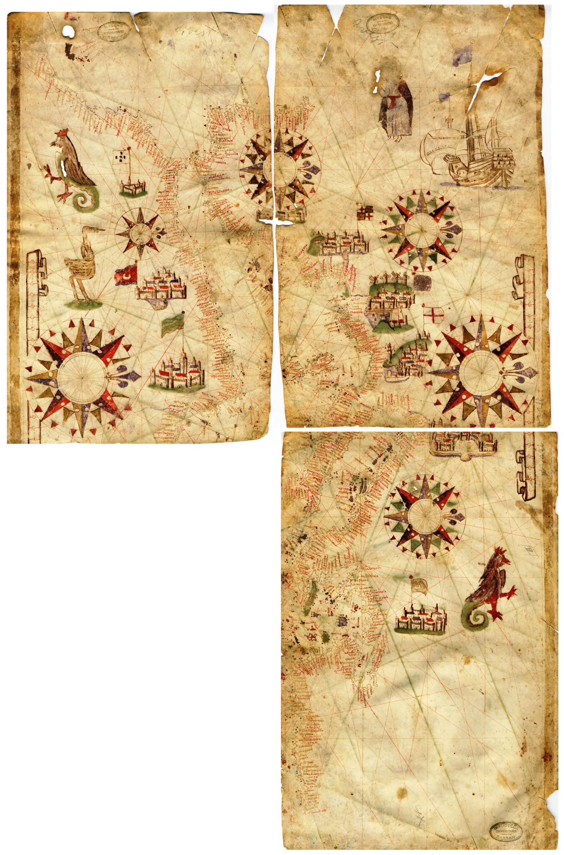
Nautical Chart of the Mediterranean Basin. (Carta Nautica Del Bacino Del Mediterraneo) 1553
- Regular price
-
$78.95 - Regular price
-
$73.95 - Sale price
-
$78.95
Buy one map, get any other map in our collection for 50% OFF! Add to cart to see discount.
Couldn't load pickup availability
About This Map
Discover the timeless beauty of our fine art quality printed reproduction of this antique map. Perfect for history enthusiasts, collectors, and interior decorators.
Restored with meticulous attention to detail by our team with over a decade of experience, this stunning reproduction captures the intricate artistry and historical significance of the original map.
Whether you're a collector or seeking a unique decor piece, this archival-quality map reproduction is a timeless addition to any space. Order now to bring history to life!
territorial divisions. Nautical charts came into use on sailing vessels in the Mediterranean toward the end of the 13th century, coinciding with much broader seafaring activity and exploration. These charts supplemented the written instructions, or portolanos, which had been used for several centuries and thus were called portolan charts. The main centers of production for these charts were Spain and northern Italy. The Carta nautica del bacino del Mediterraneo (Nautical chart of the Mediterranean basin), the only one of its type from the archives and libraries of Sardinia, is a testimony to the cultural and business relations that existed between Sardinia and Catalonia in the 16th century. Originally traced on a single sheet of paper, the map was divided into four parts and used in the binding of two volumes. The fourth part of the document has not survived. The chart is attributed to the workshop of Mateus Prunes (1532--94), a leading member of a family of cartographers who lived and worked on the island of Majorca from the early 16th century to the late 17th century.Created by Mateus Prunes in 1553.
- Title devised, in English, by Library staff.
- Original resource extent: 3 parchment sheets; 365 x 228 millimeters.
- Original resource at: University Library of Sassari.
- Content in Catalan.
- Description based on data extracted from World Digital Library, which may be extracted from partner institutions.
- For the best legibility, order your map in the original size or larger. Most maps have intricate detail and small text that is best appreciated when the print size hasn't been reduced.
- Sizes labeled "Fits a Standard Frame" will drop right into any frame that you purchase in that size. The sizes that we offer are commonly available online and at most retail stores.
- Our standard sizes are recommendations based on the aspect ratio of the original map, but still may require some added "white space" in one dimension to fit.
- Non-standard sizes will require custom framing, and we suggest taking your print to the frame shop of your choice after you receive it for the best results.
- Custom sizes are available, simply contact us for a quote.
Below is an approximation of the scale of a few standard sizes, and how they might appear in your space.

