
Newest Map of Arabia. (Neueste Karte Von Arabien) 1845
- Regular price
-
$54.95 - Regular price
-
$49.95 - Sale price
-
$54.95
Buy one map, get any other map in our collection for 50% OFF! Add to cart to see discount.
Couldn't load pickup availability
About This Map
Discover the timeless beauty of our fine art quality printed reproduction of this antique map. Perfect for history enthusiasts, collectors, and interior decorators.
Restored with meticulous attention to detail by our team with over a decade of experience, this stunning reproduction captures the intricate artistry and historical significance of the original map.
Whether you're a collector or seeking a unique decor piece, this archival-quality map reproduction is a timeless addition to any space. Order now to bring history to life!
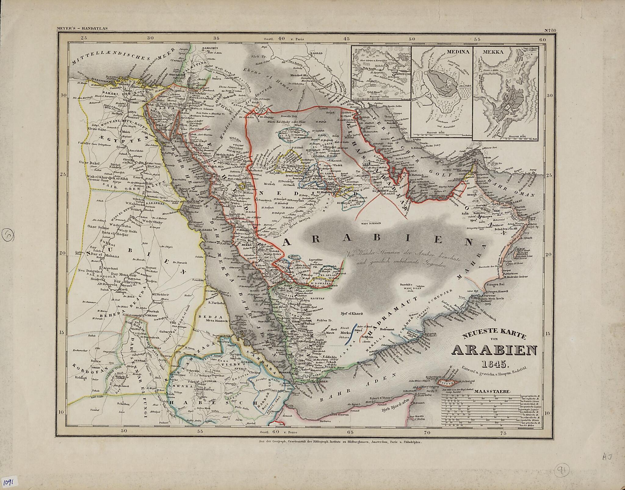
Old map of Bahrain, Djibouti, Egypt, Eritrea, Ethiopia, Iran, Islamic Republic of, Iraq, Israel, Jordan, Kuwait, Oman, Qatar, Saudi Arabia, Somalia, Sudan, United Arab Emirates, Yemen.Atlas über alle Theile der Erde (Large portable atlas of all parts of the world), published by the Bibliographic Institute of Joseph Meyer (1796-1856). The map shows the Arabian Peninsula as well as neighboring parts of Africa, including Egypt, present-day Sudan, and Abyssinia (present-day Ethiopia). Colored lines are used to demarcate kingdoms and other political entities. El Bedaa, an old city in Qatar (now the Al Bida area of Doha), is shown. Three inset maps in the upper right hand corner show the cities of El Derreyeh (Ad Dir'īyah), Mekka (Mecca), and Medina. An unusual feature of the map is the large number of distance scales provided, which reflects both the thoroughness of the mapmaker and the lack of international standardization at the time. They include geographic miles, English miles, French leagues, Dutch miles, Spanish leagues, Portuguese leagues, Italian miles, Danish miles, Swedish miles, Russian versts, Greek miles, and nautical miles. Meyer was a successful German businessman who founded the Bibliographic Institute as a publishing house in 1826. The firm specialized in producing low-cost editions of the classics, atlases, encyclopedias, and other books for purchase by the general public.
Created by Joseph Meyer, Carl Christian Franz Radefeld in 1845.
- Title devised, in English, by Library staff.
- "Scale approximately 1:9 300 000"--Note extracted from World Digital Library.
- Original resource extent: 1 map ; 35 x 29 centimeters.
- Reference extracted from World Digital Library: Heinz Sarkowski, "Meyer, Joseph," Neue Deutsche Biographie 17 (1994), http://www.deutsche-biographie.de/pnd118783610.html. External
- Original resource at: Qatar National Library.
- Content in German.
- Description based on data extracted from World Digital Library, which may be extracted from partner institutions.
Map Subjects
Arabian Gulf
Arabian Peninsula
Bahrain
Djibouti
Egypt
Eritrea
Ethiopia
Iran Islamic Republic Of
Iraq
Israel
Jordan
Kuwait
Oman
Persian Gulf
Qatar
Red Sea
Saudi Arabia
Somalia
Sudan
United Arab Emirates
Yemen
Joseph Meyer
Carl Christian Franz Radefeld
1845
- For the best legibility, order your map in the original size or larger. Most maps have intricate detail and small text that is best appreciated when the print size hasn't been reduced.
- Sizes labeled "Fits a Standard Frame" will drop right into any frame that you purchase in that size. The sizes that we offer are commonly available online and at most retail stores.
- Our standard sizes are recommendations based on the aspect ratio of the original map, but still may require some added "white space" in one dimension to fit.
- Non-standard sizes will require custom framing, and we suggest taking your print to the frame shop of your choice after you receive it for the best results.
- Custom sizes are available, simply contact us for a quote.
Below is an approximation of the scale of a few standard sizes, and how they might appear in your space.

