
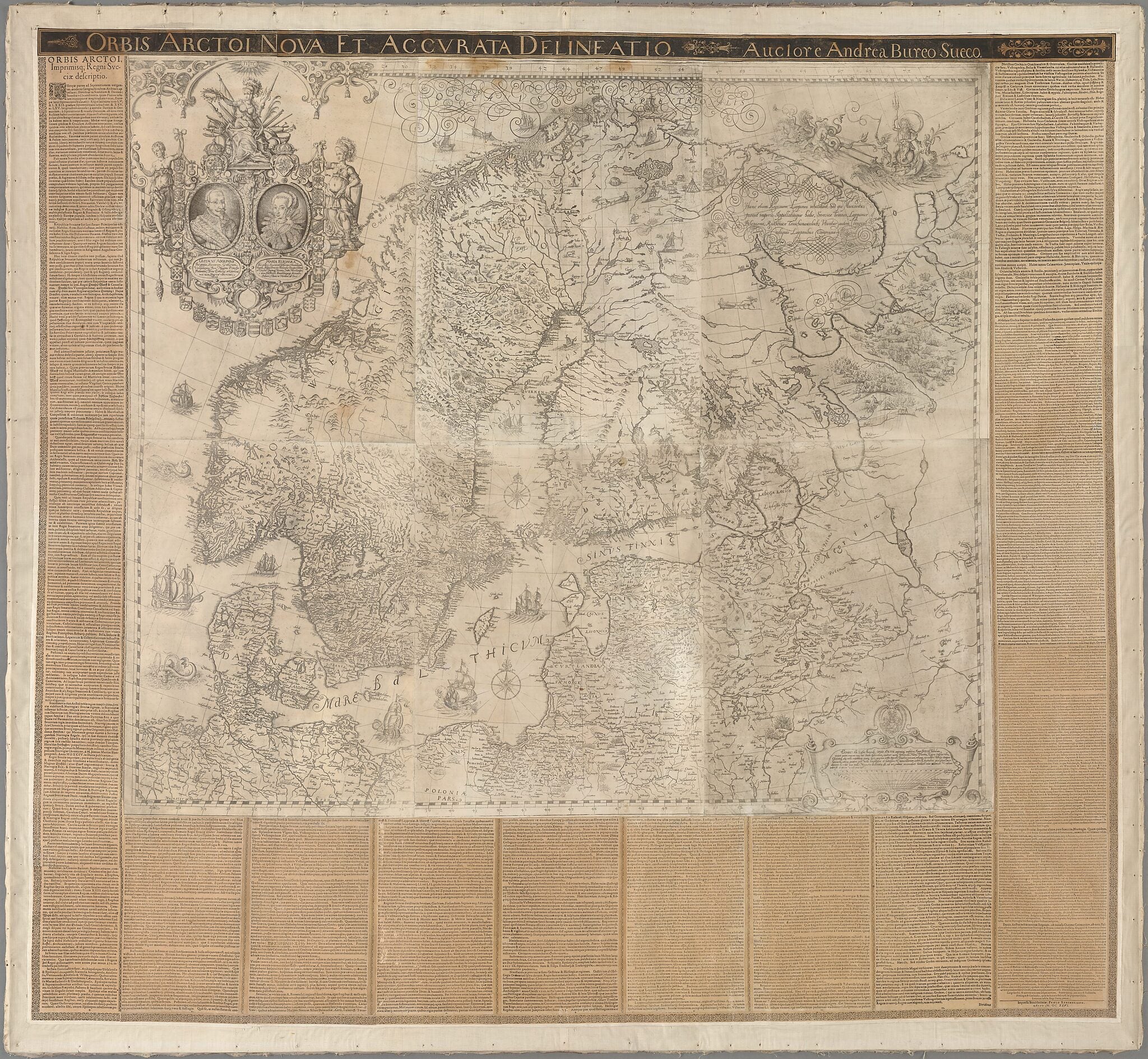
New and Detailed Sketch of the Arctic Lands, by Andreas Boreus, the Swede. (Orbis Arctoi Nova Et Accvrata Delineatio, Auctore Andrea Bureo Sueco) 1626
- Regular price
-
$213.95 - Regular price
-
$208.95 - Sale price
-
$213.95
Buy one map, get any other map in our collection for 50% OFF! Add to cart to see discount.
Couldn't load pickup availability
About This Map
Discover the timeless beauty of our fine art quality printed reproduction of this antique map. Perfect for history enthusiasts, collectors, and interior decorators.
Restored with meticulous attention to detail by our team with over a decade of experience, this stunning reproduction captures the intricate artistry and historical significance of the original map.
Whether you're a collector or seeking a unique decor piece, this archival-quality map reproduction is a timeless addition to any space. Order now to bring history to life!
Old map of Denmark, Estonia, Finland, Germany, Latvia, Lithuania, Norway, Poland, Russian Federation, Sweden.-1646) is known as the father of Swedish cartography. He embarked upon a career in the Royal Chancellery in 1602 and was entrusted with several important missions in the service of the state. In 1628 he was assigned the task of founding what was to become the Swedish National Land Survey. In 1624 he was made a member of the Swedish nobility with the name Anders Bure. Bureus completed this map of the Nordic countries in 1626 after several years of collecting data. It was printed on a scale of 1:2,000,000 on six sheets that could be assembled as a wall map measuring 113 by 128 centimeters. The projection is conic and Ilha do Corvo in the Azores serves as the prime meridian. Bureus annotated the map with topographical and ethnographical data in Latin. The magnificent cartouche portrays King Gustav II Adolf (1594--1632) and Queen Maria Eleonora (1599--1655), surrounded by the coats of arms of the Swedish provinces. Three female figures at the top symbolize war, wisdom, and courage. A circular space was left vacant for the yet-to-be-born heir or heiress to the throne. The map is a testament to the imperial greatness of the Swedish Empire and was intended to be circulated among the prominent European courts. It was published in many editions, including in several contemporary atlases.
Created by Anders Bure in 1626.
- Title devised, in English, by Library staff.
- "Shelfmark: KoB Största format"--Note extracted from World Digital Library.
- Original resource extent: 6 sheets, paper ; 113 x 128 centimeters.
- Original resource at: National Library of Sweden.
- Content in Latin.
- Description based on data extracted from World Digital Library, which may be extracted from partner institutions.
Map Subjects
Denmark
Estonia
Ethnography
Finland
Germany
Gustav II Adolf King Of Sweden
Latvia
Lithuania
Maria Eleonora Queen Of Sweden
Norway
Poland
Portraits
Russian Federation
Sweden
Anders Bure
1626
- For the best legibility, order your map in the original size or larger. Most maps have intricate detail and small text that is best appreciated when the print size hasn't been reduced.
- Sizes labeled "Fits a Standard Frame" will drop right into any frame that you purchase in that size. The sizes that we offer are commonly available online and at most retail stores.
- Our standard sizes are recommendations based on the aspect ratio of the original map, but still may require some added "white space" in one dimension to fit.
- Non-standard sizes will require custom framing, and we suggest taking your print to the frame shop of your choice after you receive it for the best results.
- Custom sizes are available, simply contact us for a quote.
Below is an approximation of the scale of a few standard sizes, and how they might appear in your space.

