
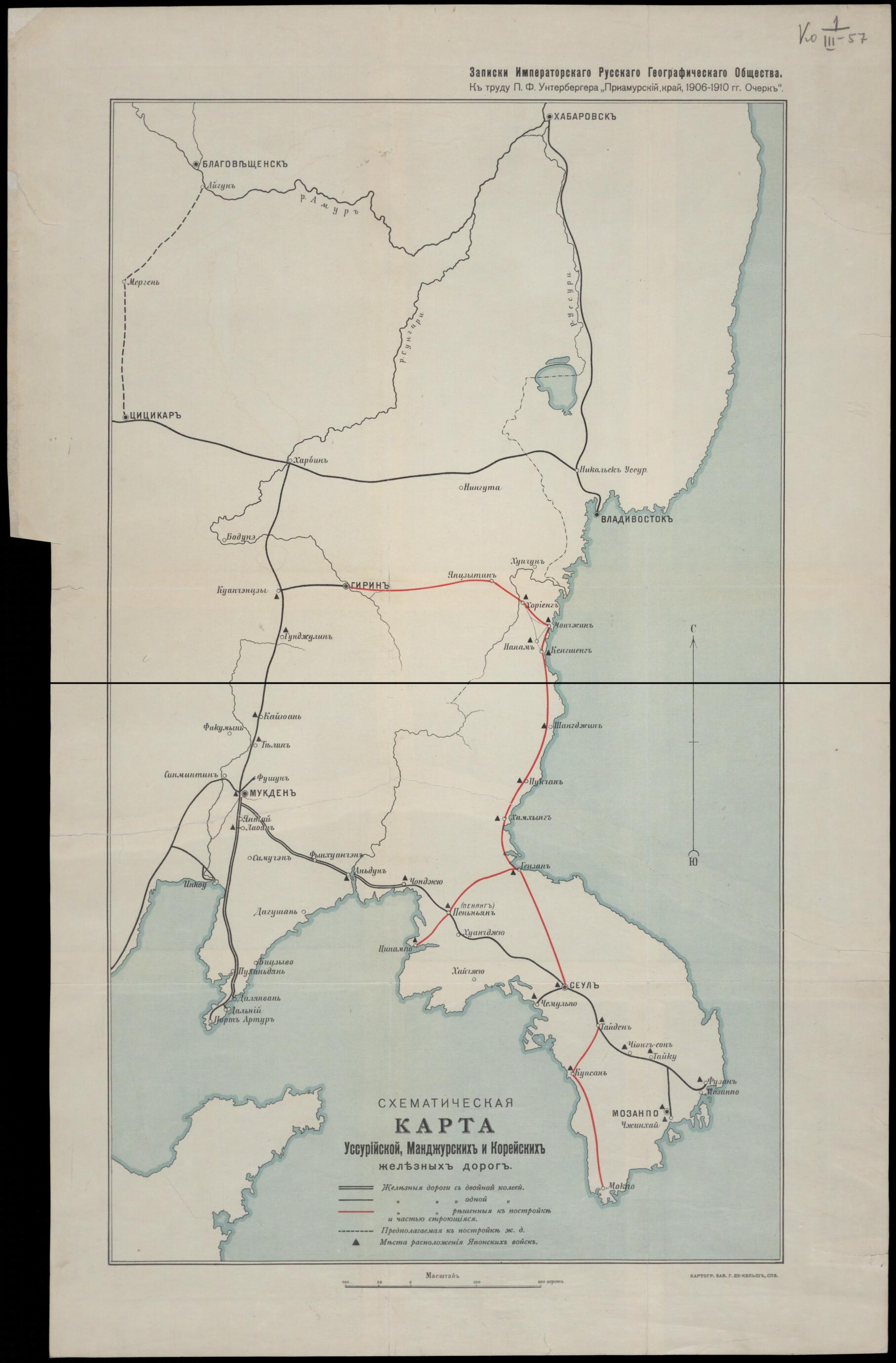
Skhematicheskai︠a︡ Karta Ussuriĭskoĭ, Mandzhurskoĭ I Koreĭskoĭ Zheleznykh Dorog. (Схематическая карта Уссурийской, Манджурской и Корейской железных дорог.) 1920
- Regular price
-
$85.95 - Regular price
-
$80.95 - Sale price
-
$85.95
Buy one map, get any other map in our collection for 50% OFF! Add to cart to see discount.
Couldn't load pickup availability
About This Map
Discover the timeless beauty of our fine art quality printed reproduction of this antique map. Perfect for history enthusiasts, collectors, and interior decorators.
Restored with meticulous attention to detail by our team with over a decade of experience, this stunning reproduction captures the intricate artistry and historical significance of the original map.
Whether you're a collector or seeking a unique decor piece, this archival-quality map reproduction is a timeless addition to any space. Order now to bring history to life!
Old map of China, Democratic People's Republic of Korea, Heilongjiang, Jilin, Liaoning Province, Primorskiy Krai, Republic of Korea, Russian Federation.black line for the completion of two tracks, a single black line for completion of one track, a red line for an established but only partially constructed railroad, and a dashed black line for a proposed (but still unbuilt) railroad. Several well-known Russian, Chinese, and Korean cities are shown on the map. These include Blagoveshchensk, Khabarovsk, and Vladivostok in Russia; Harbin, Mukden (present-day Shenyang), and Port Arthur (Lüshun) in China (Manchuria); and P'yongyang and Seoul in Korea. Black triangles signify the presence of Japanese troops in parts of northeastern China and Korea, reflecting the extensive military occupation by Japan following its victory in the Russo-Japanese War in 1904-5. In the 19th century, as the Qing Dynasty of imperial China weakened, both Russia and Japan sought to take advantage of China's waning power by expanding into areas of northeastern China and neighboring Korea. Russia forced China to cede territories north and east of the Amur and Ussuri Rivers in the Treaty of Aigun of 1858 and in the Convention of Peking of 1860 and increased its influence in Manchuria from its base of operations in Harbin. Japan moved aggressively into China and Korea after victories in the Sino-Japanese War of 1894-95 and in the Russo-Japanese War. As Japan became ascendant in the region after 1905, it targeted Russian railroad interests and reengineered local rail networks to serve its own interests. This map was compiled from notes of the Imperial Russian Geographical Society for use in a book on the Maritime Region of Russia (Primorskiy Kray, near Vladivostok). The map shows a scale at the bottom that utilizes the verst, a tsarist-era unit of distance equal to 1.07 kilometers. World Digital Library.
Created by Kelsh in 1920.
- Karta-skhema i︠a︡vli︠a︡etsi︠a︡ prilozheniem k zapiskam Russkogo Geograficheskogo Obshchestva, k trudu P.F. Unterbergera "Priamurskiĭ kraĭ, 1906-1910 gg. Ocherk". T︠S︡vetom pokazany mori︠a︡, na karte vydeleny razlichnymi znakami zheleznye dorogi, postroennye i predp.
- Bez setki koordinat.
- Original map at: Russian State Library
- Карта-схема является приложением к запискам Русского Географического Общества, к труду П.Ф. Унтербергера "Приамурский край, 1906-1910 гг. Очерк". Цветом показаны моря, на карте выделены различными знаками железные дороги, построенные и предп.
- Без сетки координат.
- For the best legibility, order your map in the original size or larger. Most maps have intricate detail and small text that is best appreciated when the print size hasn't been reduced.
- Sizes labeled "Fits a Standard Frame" will drop right into any frame that you purchase in that size. The sizes that we offer are commonly available online and at most retail stores.
- Our standard sizes are recommendations based on the aspect ratio of the original map, but still may require some added "white space" in one dimension to fit.
- Non-standard sizes will require custom framing, and we suggest taking your print to the frame shop of your choice after you receive it for the best results.
- Custom sizes are available, simply contact us for a quote.
Below is an approximation of the scale of a few standard sizes, and how they might appear in your space.

