
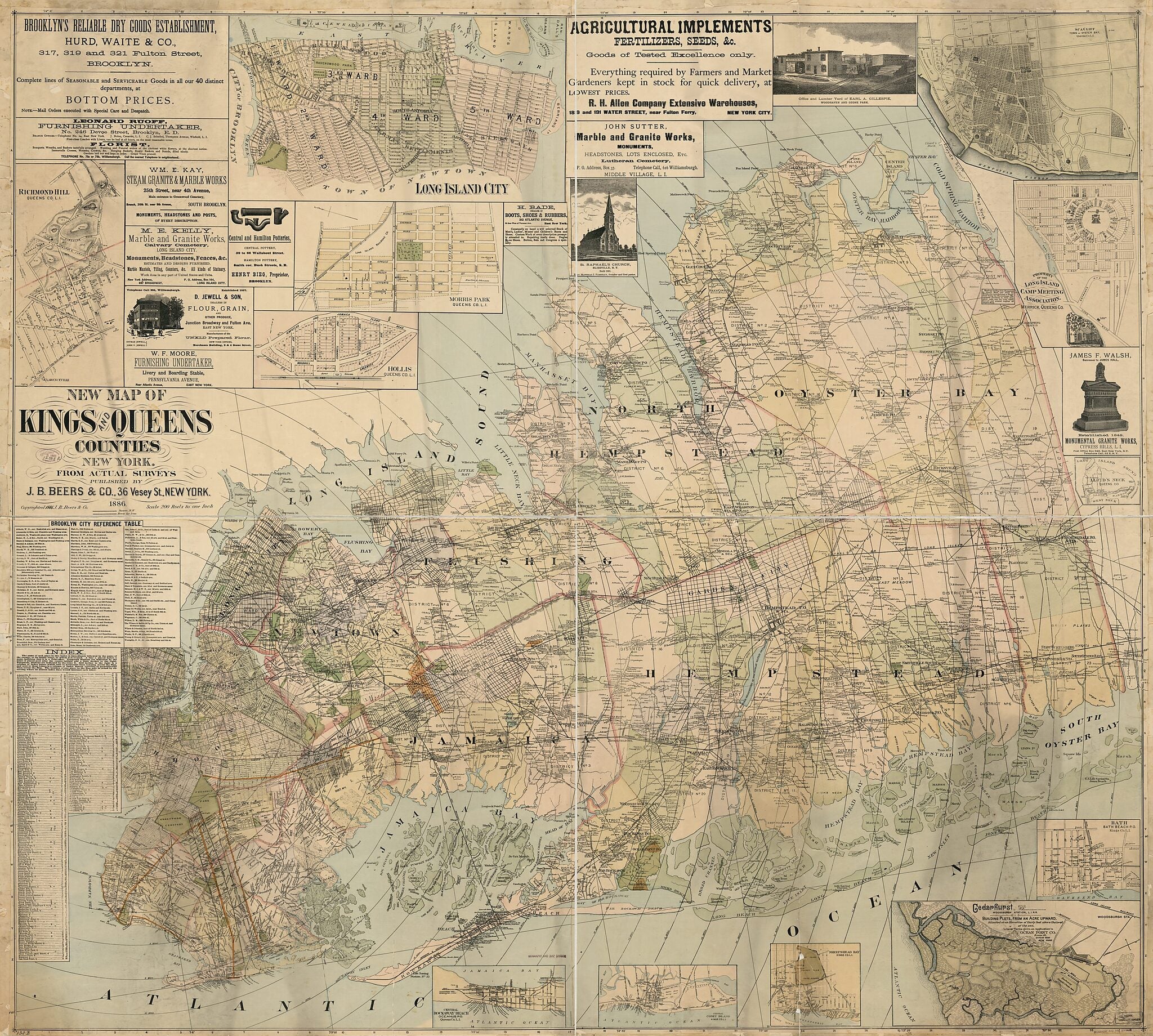
New Map of Kings and Queens Counties, New York : from Actual Surveys 1886
- Regular price
-
$219.95 - Regular price
-
$214.95 - Sale price
-
$219.95
Buy one map, get any other map in our collection for 50% OFF! Add to cart to see discount.
Couldn't load pickup availability
About This Map
Discover the timeless beauty of our fine art quality printed reproduction of this antique map. Perfect for history enthusiasts, collectors, and interior decorators.
Restored with meticulous attention to detail by our team with over a decade of experience, this stunning reproduction captures the intricate artistry and historical significance of the original map.
Whether you're a collector or seeking a unique decor piece, this archival-quality map reproduction is a timeless addition to any space. Order now to bring history to life!
Old map of Brooklyn, Brooklyn (New York), Kings County, Long Island City, Long Island City (New York), Nassau County, Nassau County (N.Y.), New York, New York (State), Queens, Queens (New York), Queens County, United States.Created by J.B. Beers & Co in 1886.
- General-content map of the present-day borough of Brooklyn (Kings County, New York City) and the entire pre-1899 area of Queens County.
- Also covers Nassau County which was formed from the eastern part of Queens County in 1899.
- Shows incorporated cities, towns (townships), numbered districts, roads, rural buildings, and rural householders' names; shows street systems in urban areas.
- Shows 1-mile radial distances from N.Y. City Hall (Manhattan).
- Relief shown by hachures.
- Partially hand-colored.
- "Copyrighted 1886 J.B. Beers & Co."
- Mounted in western/eastern segments (sheets).
- Land Ownership Map
- Includes text, index of local areas, business directory, 12 local-area insets (including Long Island City--now part of Queens Borough), advertisements, and illustrations in some advertisements.
- 2 copies
Map Subjects
Administrative And Political Divisions
Brooklyn (New York)
Brooklyn (New York N.Y.)
Kings County
Kings County (N.Y.)
Landowners
Long Island City (New York)
Long Island City (New York N.Y.)
Nassau County
Nassau County (N.Y.)
New York
New York (State)
Queens (New York)
Queens (New York N.Y.)
Queens County
Queens County (N.Y.)
United States
Brooklyn
Long Island City
Queens
J.B. Beers & Co
1886
- For the best legibility, order your map in the original size or larger. Most maps have intricate detail and small text that is best appreciated when the print size hasn't been reduced.
- Sizes labeled "Fits a Standard Frame" will drop right into any frame that you purchase in that size. The sizes that we offer are commonly available online and at most retail stores.
- Our standard sizes are recommendations based on the aspect ratio of the original map, but still may require some added "white space" in one dimension to fit.
- Non-standard sizes will require custom framing, and we suggest taking your print to the frame shop of your choice after you receive it for the best results.
- Custom sizes are available, simply contact us for a quote.
Below is an approximation of the scale of a few standard sizes, and how they might appear in your space.

