
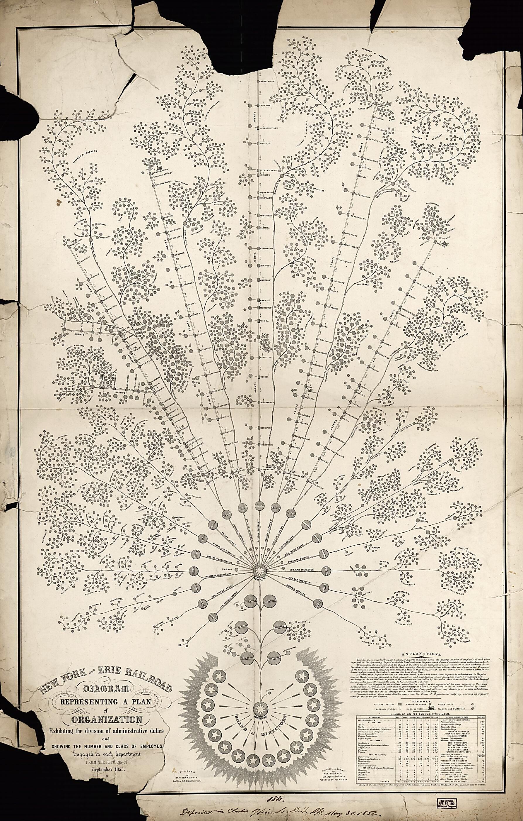
New York and Erie Railroad Diagram Representing a Plan of Organization : Exhibiting the Division of Academic Duties and Showing the Number and Class of Employés Engaged In Each Department : from the Returns of September 1855
- Regular price
-
$133.95 - Regular price
-
$128.95 - Sale price
-
$133.95
Buy one map, get any other map in our collection for 50% OFF! Add to cart to see discount.
Couldn't load pickup availability
About This Map
Discover the timeless beauty of our fine art quality printed reproduction of this antique map. Perfect for history enthusiasts, collectors, and interior decorators.
Restored with meticulous attention to detail by our team with over a decade of experience, this stunning reproduction captures the intricate artistry and historical significance of the original map.
Whether you're a collector or seeking a unique decor piece, this archival-quality map reproduction is a timeless addition to any space. Order now to bring history to life!
Old wall map / graph of New York, New York (State), Pennsylvania, United States.Created by G. H. Henshaw, D. C. (Daniel Craig) McCallum, New York and Erie Railroad Company in 1855.
- Company organizational diagrammatic map drawn in the form of a branching tree that identifies in its branches all of the functional offices of the railroad by name.
- Shows railroad trackage branches as straight lines radiating from the central office of the "Gen'l Sup't".
- The branches extend from New York (State) westward thru northern New Jersey and northern Pennsylvania to Lake Erie.
- "Published by permission."
- Includes text, note, legend of symbols, and statistical table of "Number of offices and employés classed".
Map Subjects
Graphs
New York (State)
New York And Erie Railroad Company
Pennsylvania
Railroads
United States
Wall Maps
New York
Wall Maps
G. H. Henshaw
D. C. (Daniel Craig) McCallum
New York And Erie Railroad Company
1855
- For the best legibility, order your map in the original size or larger. Most maps have intricate detail and small text that is best appreciated when the print size hasn't been reduced.
- Sizes labeled "Fits a Standard Frame" will drop right into any frame that you purchase in that size. The sizes that we offer are commonly available online and at most retail stores.
- Our standard sizes are recommendations based on the aspect ratio of the original map, but still may require some added "white space" in one dimension to fit.
- Non-standard sizes will require custom framing, and we suggest taking your print to the frame shop of your choice after you receive it for the best results.
- Custom sizes are available, simply contact us for a quote.
Below is an approximation of the scale of a few standard sizes, and how they might appear in your space.

