
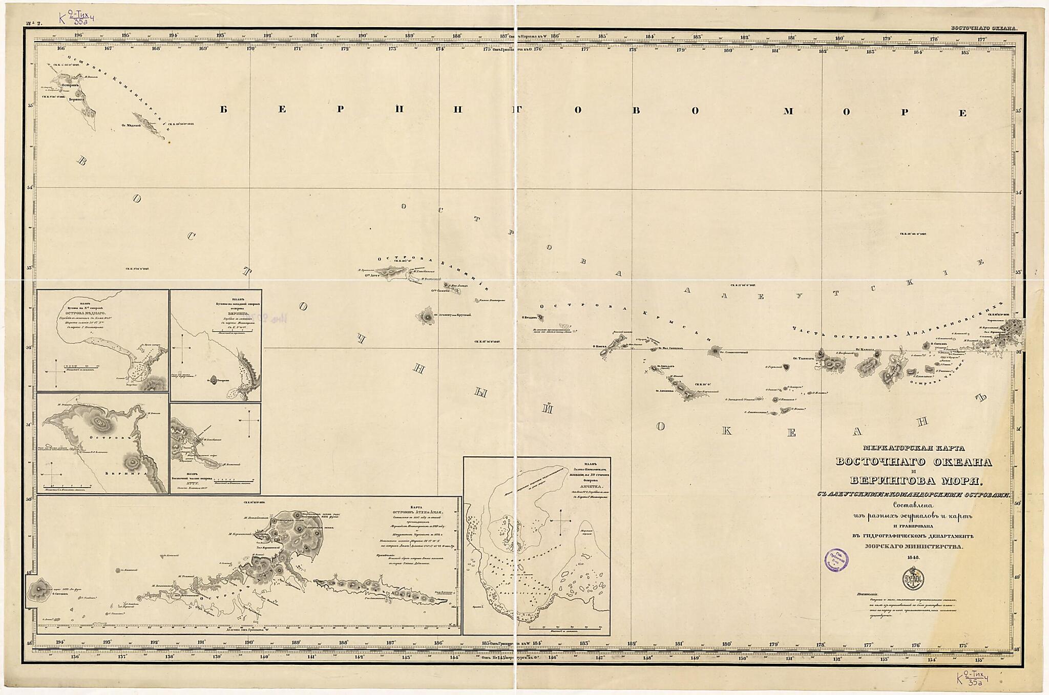
Merkatorskai︠a︡ Karta Vostochnogo Okeana I Beringova Mori︠a︡. (Меркаторская карта Восточного океана и Берингова моря.) 1848
- Regular price
-
$99.95 - Regular price
-
$94.95 - Sale price
-
$99.95
Buy one map, get any other map in our collection for 50% OFF! Add to cart to see discount.
Couldn't load pickup availability
About This Map
Discover the timeless beauty of our fine art quality printed reproduction of this antique map. Perfect for history enthusiasts, collectors, and interior decorators.
Restored with meticulous attention to detail by our team with over a decade of experience, this stunning reproduction captures the intricate artistry and historical significance of the original map.
Whether you're a collector or seeking a unique decor piece, this archival-quality map reproduction is a timeless addition to any space. Order now to bring history to life!
Old map of Russian Federation.Created by Gidrograficheskiĭ Departament Morskogo Ministerstva in 1848.
- Sostavlena iz raznykh zhurnalov i kart. Kartograficheskai︠a︡ setka cherez 1°, vykhody koordinat cherez 30'; schet dolgot ot Parizha, Grinvicha, Sankt-Peterburga. Dop.karty: [1] Plan Bukhty na N-oĭ storone ostrova Mednago. Glubina v sazheni︠a︡kh. S karty G. Ingenstrema. M-b.
- Pokazany: rel'ef shtrikhami,otmetki glubin v sazheni︠a︡kh, meli, rify, podvodnye i nadvodnye kamni, magnitnye sklonenii︠a︡. Primechanie: ostrova i meli, otmechennye voprositel'nymi znakami, ni kem iz moreplavateleĭ ne byli usmotreny i naneseny na kartu so slov promysh.
- Original map at: National Library of Russia
- Составлена из разных журналов и карт. Картографическая сетка через 1°, выходы координат через 30'; счет долгот от Парижа, Гринвича, Санкт-Петербурга. Доп.карты: [1] План Бухты на N-ой стороне острова Меднаго. Глубина в саженях. С карты Г. Ингенстрема. М-б.
- Показаны: рельеф штрихами,отметки глубин в саженях, мели, рифы, подводные и надводные камни, магнитные склонения. Примечание: острова и мели, отмеченные вопросительными знаками, ни кем из мореплавателей не были усмотрены и нанесены на карту со слов промыш.
Map Subjects
Russian Federation
Siberia
Gidrograficheskiĭ Departament Morskogo Ministerstva
1848
- For the best legibility, order your map in the original size or larger. Most maps have intricate detail and small text that is best appreciated when the print size hasn't been reduced.
- Sizes labeled "Fits a Standard Frame" will drop right into any frame that you purchase in that size. The sizes that we offer are commonly available online and at most retail stores.
- Our standard sizes are recommendations based on the aspect ratio of the original map, but still may require some added "white space" in one dimension to fit.
- Non-standard sizes will require custom framing, and we suggest taking your print to the frame shop of your choice after you receive it for the best results.
- Custom sizes are available, simply contact us for a quote.
Below is an approximation of the scale of a few standard sizes, and how they might appear in your space.
